New Tornado Watch Issued for Parts of Central Alabama Until 5 am Sunday
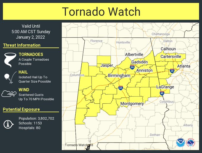
The SPC along with NWS Birmingham has issued a new Tornado Watch until 5 am for the following counties in Central Alabama: Autauga, Bibb, Blount, Calhoun, Chambers, Cherokee, Chilton, Clay, Cleburne, Coosa, Dallas, Elmore, Etowah, Fayette, Greene, Hale, Jefferson, Lamar, Marengo, Perry, Pickens, Randolph, Shelby, St. Clair, Sumter, Talladega, Tallapoosa, Tuscaloosa, Walker, and Winston. This new watch replaces the watch that expired at 10 pm.
Be sure to have a reliable way to get warnings tonight. That way should be loud enough to wake you from sleep. Stay weather aware.
Here is the text from the SPC:
The NWS Storm Prediction Center has issued a
* Tornado Watch for portions of
— Alabama
— Northwest Georgia
* Effective this Saturday night and Sunday morning from 1010 PM until 500 AM CST.
* Primary threats include…
— A couple tornadoes possible
— Scattered damaging wind gusts to 70 mph possible
SUMMARY… A severe-storm/tornado risk will likely persist through parts of the overnight, at least on an isolated basis, given a moist/modestly unstable environment and very strong shear in advance of a southeast-moving cold front.
The tornado watch area is approximately along and 55 statute miles north and south of a line from 55 miles southwest of Tuscaloosa, AL to 50 miles southeast of Rome, GA.
PRECAUTIONARY/PREPAREDNESS ACTIONS…
REMEMBER… A Tornado Watch means conditions are favorable for tornadoes and severe thunderstorms in and close to the watch area. Persons in these areas should be on the lookout for threatening weather conditions and listen for later statements and possible warnings.
Category: Alabama's Weather, ALL POSTS, Severe Weather
About the Author (Author Profile)
Scott Martin is an operational meteorologist, professional graphic artist, musician, husband, and father. Not only is Scott a member of the National Weather Association, but he is also the Central Alabama Chapter of the NWA president. Scott is also the co-founder of Racecast Weather, which provides forecasts for many racing series across the USA. He also supplies forecasts for the BassMaster Elite Series events including the BassMaster Classic.Subscribe
If you enjoyed this article, subscribe to receive more just like it.


