Brief Check on Our Weather Situation Just After 7 pm
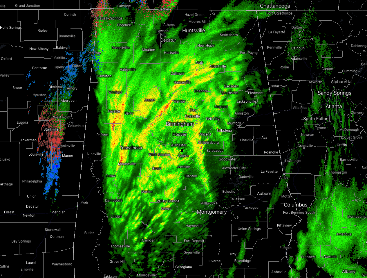
Temperatures across much of North/Central Alabama continues to be above the freezing mark which is keeping nearly everything as rainfall at this point, but those extreme northwestern parts of the area have dropped into the lower 30s and the precipitation is making the changeover to snow.
That changeover will move across the area eastward as those temperatures continue to fall, and we could see the changeover to snow start to occur at some point in the 8-9 pm time frame for theI-65 corridor, and for the eastern half of the area by the 10-11 pm time frame.
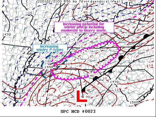
Here is a rarity for North/Central Alabama… The SPC has issued a Mesoscale Discussion on the increasing potential for winter precipitation, including moderate to heavy snow, over the northern parts of the area. Here is the text from the SPC:
SUMMARY… Periods of moderate to heavy snow will likely develop through this evening, as temperatures begin to drop and forcing for ascent strengthens markedly. Snow rates of 0.5-1 in/hour will be possible with the strongest bands. Brief periods of mixed precipitation including sleet and freezing rain may also develop.
DISCUSSION… As of 0015 UTC, a potent mid-level shortwave trough was analyzed via WV imagery across the eastern ARKLATEX. To the south, a 90-100 kt jet streak was beginning to round the base of the positively tilted trough moving onshore across southwestern LA. A broad area of low pressure at the surface was centered across western GA, with an expanding precipitation shield noted to the northwest of the low and ongoing convection.
Recent surface observations across southwestern TN and northern MS have shown an increase in the occurrence of snow and mixed precipitation types over the last few hours, with diurnal cooling taking place. Strong height falls from the approaching trough are forecast to advect eastward over the next few hours as the trough becomes negatively tilted, augmenting surface mass response and deepening the aforementioned surface low. Low-level cold advection should follow suit, accelerating the change over, first to mixed precipitation, and then quickly to snow of parts of the expanding precipitation field. While temperatures remain mild, the rain/snow line should move eastward with time, concurrent with increasing precipitation rates from strengthening 850-700 frontogenesis and the development of convective bands owing to subtle buoyancy aloft.
Regional soundings show favorable profiles for periods of moderate and occasional heavy snow, expanding northeastward with time from northern AL into eastern/central TN along the western slopes of the southern Appalachians. Snow rates of 0.5 to 0.75 in/hr will be possible for several hours, resulting in reduced visibility and potential travel issues. Localized 1+ in/hr rates may also be possible beneath the heavier convective elements or near local topography favorable for orographic enhancement. Snow may linger for a few hours overnight before forcing and dry air to the west shift precipitation northeastward.
Category: Alabama's Weather, ALL POSTS, Winter Weather
About the Author (Author Profile)
Scott Martin is an operational meteorologist, professional graphic artist, musician, husband, and father. Not only is Scott a member of the National Weather Association, but he is also the Central Alabama Chapter of the NWA president. Scott is also the co-founder of Racecast Weather, which provides forecasts for many racing series across the USA. He also supplies forecasts for the BassMaster Elite Series events including the BassMaster Classic.Subscribe
If you enjoyed this article, subscribe to receive more just like it.


