SPC Upgrades Part of Central Alabama to a Slight Risk for Later Today
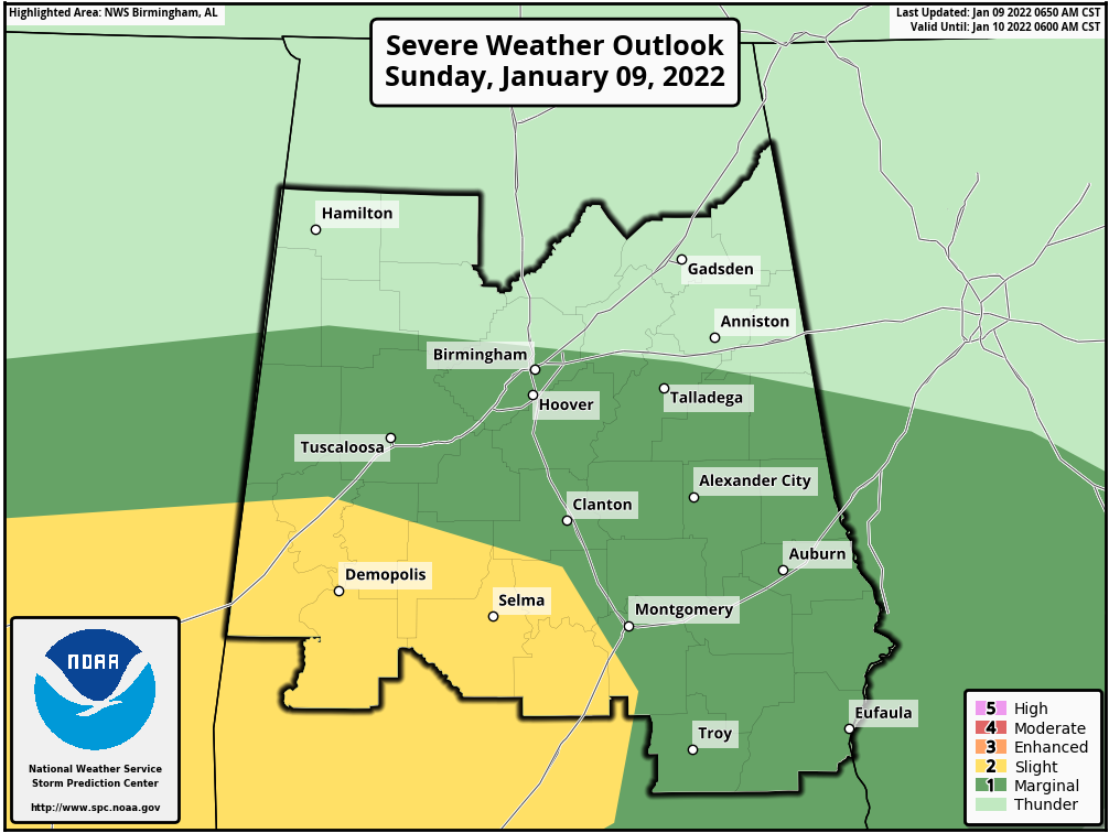
The Storm Prediction Center has upgraded the south and southwestern parts of the area to a Slight Risk for severe storms today. This includes locations along and south of a line from just north of Geiger (Sumter Co.) to just south of Billingsley (Autauga Co.) to just west of Sprague (Montgomery Co.). A Marginal Risk continues for much of the rest of Central Alabama south of a line from Fayette (Fayette Co.) to Fultondale (Jefferson Co.) to just north of Woodland (Randolph Co.).
Damaging wind gusts, a couple of tornadoes, and isolated large hail will be possible today across parts of Central Alabama. Here is the latest forecast discussion from the SPC:
A positive-tilt, southern stream trough will phase gradually with a deep northern stream trough over the Great Lakes. In the immediate wake of the Great Lakes midlevel trough, a continental polar air mass will spread southeastward across the OH/TN/lower MS Valleys and reach the northern Gulf of Mexico tonight. Moisture return in advance of the associated cold front has brought boundary-layer dewpoints in the mid 60s as far north as southern AR and central MS (with near 70 F along the northwest Gulf coast) this morning, and the moisture will continue to spread northeastward today across MS and central/southern AL. The primary low-level jet will develop eastward from the Ark-La-Miss this morning along the north edge of the warm/moist sector, and continue eastward across northern MS/AL during the day to north GA by this evening.
Midlevel lapse rates of 7-8 C/km per regional 12z soundings and pockets of surface heating will combine with the aforementioned moisture advection to support MLCAPE values of 1000-2000 J/kg in the warm sector from later this morning into the afternoon. Though low-level shear will tend to weaken from west-to-east during the day, 12z soundings suggest the warm sector will destabilize, and convective inhibition will be minimal by late morning, which should support additional storm development prior to weakening of vertical shear. Effective bulk shear of 35-40 kt and effective SRH of 150-200 m2/s2 will support the potential for a few supercells capable of producing damaging winds, a couple of tornadoes, and isolated large hail before vertical shear weakens and the threat diminishes by this evening.
Category: Alabama's Weather, ALL POSTS, Severe Weather
About the Author (Author Profile)
Scott Martin is an operational meteorologist, professional graphic artist, musician, husband, and father. Not only is Scott a member of the National Weather Association, but he is also the Central Alabama Chapter of the NWA president. Scott is also the co-founder of Racecast Weather, which provides forecasts for many racing series across the USA. He also supplies forecasts for the BassMaster Elite Series events including the BassMaster Classic.Subscribe
If you enjoyed this article, subscribe to receive more just like it.


