Mesoscale Discussion — Tornado Watch May Be Extended Eastward
Strong to severe storms will continue northeastward into central Alabama. Some local extension in the watch area may be needed if storms maintain intensity through the afternoon. Here is the latest discussion from the SPC:
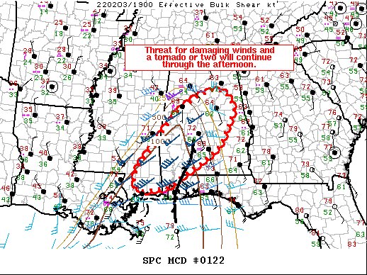
Semi-organized linear segments continue to move eastward across southern MS/AL. An embedded supercell in the Sumter County, AL, vicinity has been the most organized storm this afternoon. A possible TDS was evident on the KDGX radar around 1:10 PM CST with this storm. Storms moving into central Alabama may reach the eastern edge of the watch prior to expiration. Buoyancy becomes more limited with northeastward extent, but local extensions in area of the watch may be needed if storms maintain intensity. Across southern MS/AL, storms have been less organized despite greater buoyancy. Showers continue to develop along a pre-frontal convergence zone as well. This activity has struggled to mature. The probability of a discrete storm ahead of the cold front remains low. With time, the stronger mid-level forcing will lift northeastward and the surface low along with it. Linear forcing along the front should keep the primary threat damaging winds, given the strong low level winds that will remain.
Category: Alabama's Weather, ALL POSTS, Severe Weather
About the Author (Author Profile)
Scott Martin is an operational meteorologist, professional graphic artist, musician, husband, and father. Not only is Scott a member of the National Weather Association, but he is also the Central Alabama Chapter of the NWA president. Scott is also the co-founder of Racecast Weather, which provides forecasts for many racing series across the USA. He also supplies forecasts for the BassMaster Elite Series events including the BassMaster Classic.Subscribe
If you enjoyed this article, subscribe to receive more just like it.


