CANCELED — Tornado Warning for Parts of Walker Co. Until 5 pm
…A TORNADO WARNING REMAINS IN EFFECT UNTIL 500 PM CST FOR CENTRAL
WALKER…NORTH CENTRAL TUSCALOOSA AND SOUTHEASTERN FAYETTE
COUNTIES…
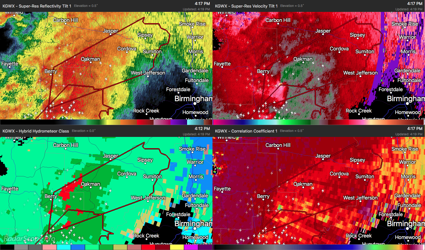
AT 416 PM CST, A CONFIRMED LARGE AND EXTREMELY DANGEROUS TORNADO WAS
LOCATED OVER BOLEY SPRINGS, OR 19 MILES EAST OF FAYETTE, MOVING
NORTHEAST AT 55 MPH.
THIS IS A PARTICULARLY DANGEROUS SITUATION. TAKE COVER NOW!
HAZARD…DAMAGING TORNADO.
SOURCE…RADAR CONFIRMED TORNADO.
IMPACT…YOU ARE IN A LIFE-THREATENING SITUATION. FLYING DEBRIS MAY
BE DEADLY TO THOSE CAUGHT WITHOUT SHELTER. MOBILE HOMES
WILL BE DESTROYED. CONSIDERABLE DAMAGE TO HOMES,
BUSINESSES, AND VEHICLES IS LIKELY AND COMPLETE DESTRUCTION
IS POSSIBLE.
LOCATIONS IMPACTED INCLUDE…
JASPER, SUMITON, CORDOVA, DORA, BERRY, PARRISH, OAKMAN, SIPSEY,
GORGAS STEAM PLANT, GORGAS, BOLEY SPRINGS, ROCKY HOLLOW, BURNWELL,
BELOIT, QUINTON, LYNNS PARK, WHITSON, EMPIRE, WEST CORONA AND
POWELLVILLE.
PRECAUTIONARY/PREPAREDNESS ACTIONS…
TO REPEAT, A LARGE, EXTREMELY DANGEROUS AND POTENTIALLY DEADLY
TORNADO IS ON THE GROUND. TO PROTECT YOUR LIFE, TAKE COVER NOW! MOVE
TO A BASEMENT OR AN INTERIOR ROOM ON THE LOWEST FLOOR OF A STURDY
BUILDING. AVOID WINDOWS. IF YOU ARE OUTDOORS, IN A MOBILE HOME, OR IN
A VEHICLE, MOVE TO THE CLOSEST SUBSTANTIAL SHELTER AND PROTECT
YOURSELF FROM FLYING DEBRIS.
The National Weather Service in Birmingham has issued a
* Tornado Warning for…
Central Walker County in central Alabama…
North central Tuscaloosa County in west central Alabama…
Southeastern Fayette County in west central Alabama…
* Until 500 PM CST.
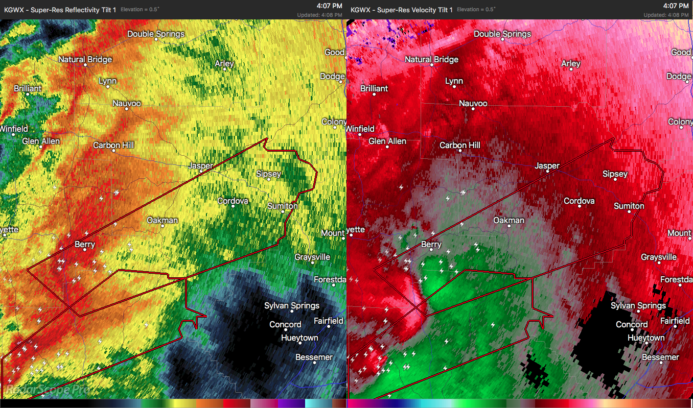
* At 407 PM CST, a severe thunderstorm capable of producing a tornado
was located 7 miles south of Berry, or 13 miles southeast of
Fayette, moving northeast at 65 mph.
HAZARD…Tornado.
SOURCE…Radar indicated rotation.
IMPACT…Flying debris will be dangerous to those caught without
shelter. Mobile homes will be damaged or destroyed.
Damage to roofs, windows, and vehicles will occur. Tree
damage is likely.
* Locations impacted include…
Jasper, Sumiton, Cordova, Dora, Berry, Parrish, Oakman, Sipsey,
Gorgas Steam Plant, Gorgas, Boley Springs, Rocky Hollow, Burnwell,
Beloit, Quinton, Lynns Park, Whitson, Empire, West Corona and
Powellville.
PRECAUTIONARY/PREPAREDNESS ACTIONS…
TAKE COVER NOW! Move to a basement or an interior room on the lowest
floor of a sturdy building. Avoid windows. If you are outdoors, in a
mobile home, or in a vehicle, move to the closest substantial shelter
and protect yourself from flying debris.
Category: Alabama's Weather, ALL POSTS, Severe Weather
About the Author (Author Profile)
Scott Martin is an operational meteorologist, professional graphic artist, musician, husband, and father. Not only is Scott a member of the National Weather Association, but he is also the Central Alabama Chapter of the NWA president. Scott is also the co-founder of Racecast Weather, which provides forecasts for many racing series across the USA. He also supplies forecasts for the BassMaster Elite Series events including the BassMaster Classic.Subscribe
If you enjoyed this article, subscribe to receive more just like it.


