Saturday Evening Forecast Update; Severe Storms Possible on Tuesday
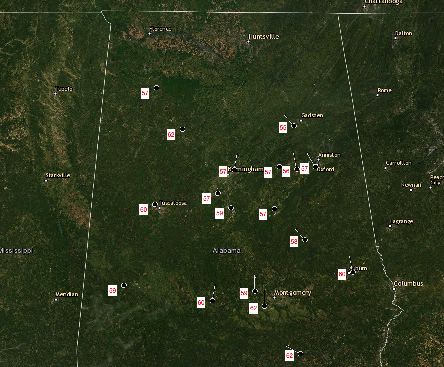
Recorded Temperatures from This Afternoon
Afternoon highs (not official at the moment) reached as high as 62 degrees in the southern and southeastern parts of the area in Troy and Montgomery. The cool spot for the day was Gadsden as they topped out at 55 degrees. The Birmingham Airport only reached 57 degrees, along with Bessemer, Sylacauga, and Anniston.
Weather for This Evening Through the Overnight Hours
Skies will remain clear throughout the rest of your Saturday and into the predawn hours on Sunday. It will be a little chilly, as overnight lows will bottom out in the mid-20s to the mid-40s.
Sunday’s Weather
Almost a picture-perfect day weather-wise in store for Central Alabama, as skies will be sunny for much of the daylight hours, with only a few clouds moving into the western parts of the area late in the afternoon. Highs will range from the lower 60s to the upper 60s.
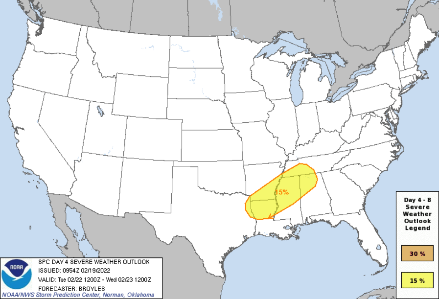
Risk of Severe Weather Introduced for Tuesday
On Tuesday, North/Central Alabama will be located in a warm sector out ahead of a very slowly moving, nearly stationary cold front. With the daytime heating, we could see some instability start to build across portions of the area, and that may help to fire off some convective thunderstorms. With decent wind shear in place, a few tornadoes, damaging winds up to 60 mph, and hail up to quarter size will be possible in the 15% severe weather risk area drawn on the map from the SPC. That risk area currently includes locations north and west of a line from just west of Hytop to Springville to Tuscaloosa to Gainesville. We’ll have a much better look at this developing situation throughout the day on Sunday.
Three Tornadoes Confirmed Touched Down on Thursday
The first confirmed tornado touched down just southeast of Berry in Tuscaloosa County around 4:14 pm and traveled on the ground for approximately 3.45 miles before lifting just east of Berry after crossing over into Fayette County. It was rated an EF-0 with winds reaching 75 mph.
The second confirmed tornado touched down just northwest of Graysville in Jefferson County around 4:53 pm and traveled on the ground for approximately 4.65 miles before lifting just northeast of Lynn Crossing. It was rated an EF-1 with winds reaching 100 mph.
The third confirmed tornado touched down just north-northeast of Meadowbrook in Shelby County around 6:08 pm and traveled on the ground for approximately 12.63 miles before lifting just east-northeast of Leeds in St. Clair County. It was rated an EF-1 with winds reaching 95 mph.
Category: Alabama's Weather, ALL POSTS, Severe Weather
About the Author (Author Profile)
Scott Martin is an operational meteorologist, professional graphic artist, musician, husband, and father. Not only is Scott a member of the National Weather Association, but he is also the Central Alabama Chapter of the NWA president. Scott is also the co-founder of Racecast Weather, which provides forecasts for many racing series across the USA. He also supplies forecasts for the BassMaster Elite Series events including the BassMaster Classic.Subscribe
If you enjoyed this article, subscribe to receive more just like it.


