A Late Look at Friday’s Severe Weather Threat for North/Central Alabama
A very dynamic system will move across North/Central Alabama throughout the day on Friday that will bring a risk of severe storms to the area, including damaging winds, tornadoes, and large hail. Also, with heavy rain falling at times, a few localized flooding issues may occur. Here is the latest…
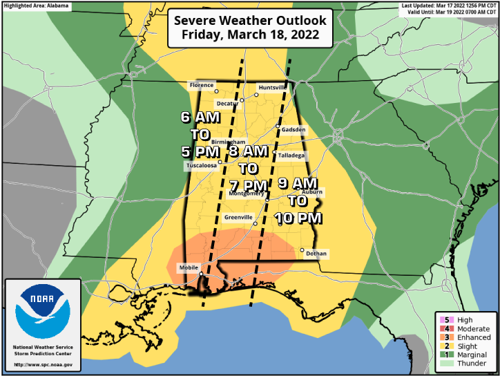
A Slight Risk is up for nearly all of North/Central Alabama, except for the extreme western portions of Lamar and Pickens counties and for the extreme eastern portions of Jackson and DeKalb counties. Those locations are under a Marginal Risk for Severe Storms. An Enhanced Risk is up for much of South Alabama.
The timing for the first round of stronger to severe storms will start from roughly 6 am and will go to around midday from west to east. Damaging winds up to 60 mph and quarter size hail will be possible with any severe storm, and there is a very small, non-zero chance of a tornado.
The timing for the second round of stronger to severe storms will start around 1 pm and persist across the area until exiting the eastern parts of the area around 10 pm. This round will be conditional on the recovery of the atmosphere after the morning round. Models are showing that to happen, so all modes of severe weather will be possible, including tornadoes.
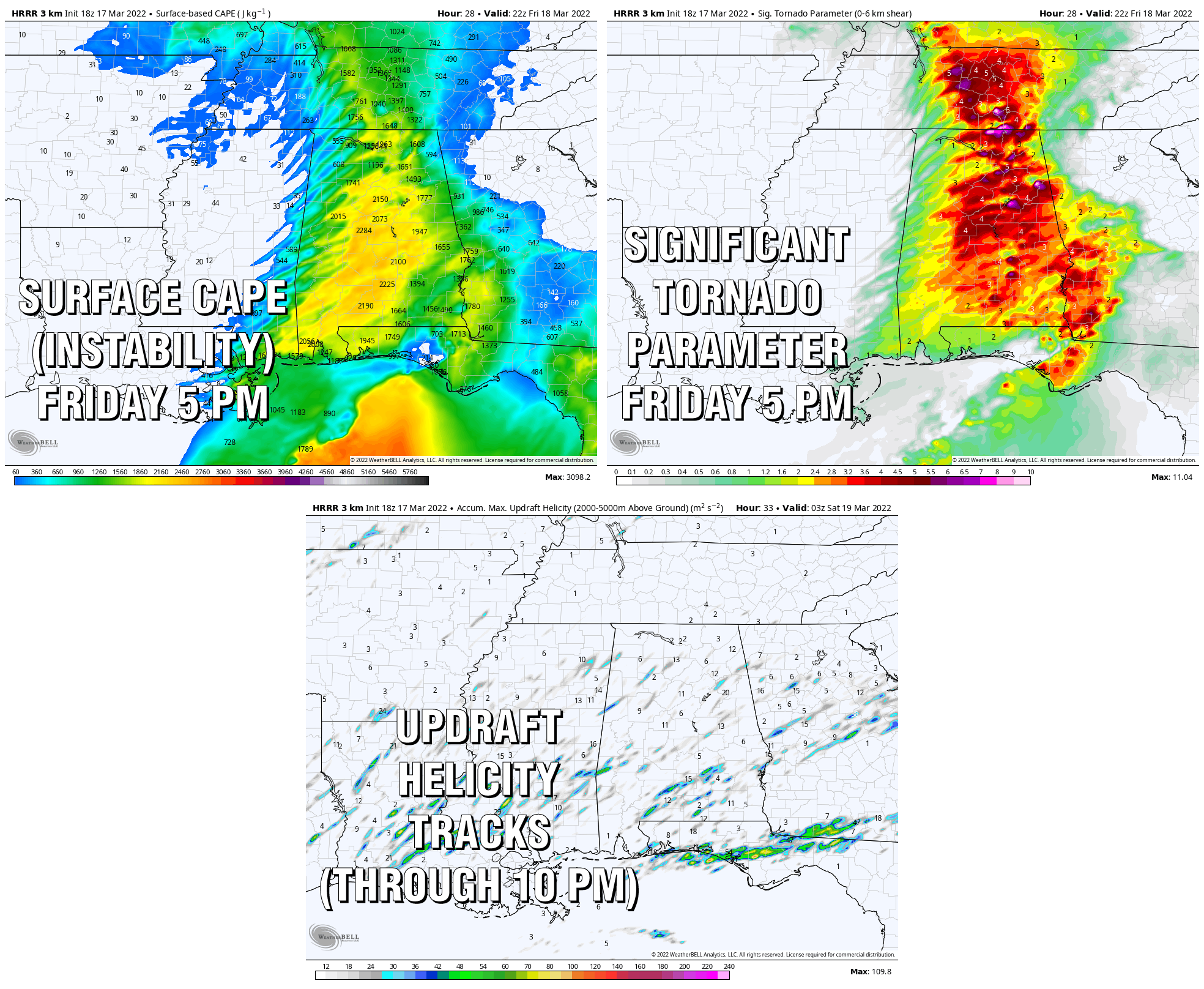
The 18z HRRR shows a highly unstable airmass during the afternoon hours, mixed with a good bit of shear, helicity will be there giving storms the potential to start rotating. Significant Tornado Parameter values are currently modeled in the 3.0-4.0 range, with some locations reaching up to 8.0. And the Updraft Helicity Tracks tool definitely shows the potential for those rotating supercells.
This may be one of these systems where the severe risks may actually be increased right before it starts, and I wouldn’t be surprised to see the Enhanced Risk expanded into portions of Central Alabama when the Day One Severe Weather Outlook is released after midnight tonight.

You know the drill… Have multiple ways to get warnings, have a safe place to go to if your location goes under a warning, and have a safety kit in that safe place. If you live in a mobile or manufactured home, go ahead and have a plan ready to get out and go to a more sturdy structure when a tornado watch is issued, or if you are already close by, be ready to act as soon as your location goes under a warning.
Category: Alabama's Weather, ALL POSTS, Severe Weather
About the Author (Author Profile)
Scott Martin is an operational meteorologist, professional graphic artist, musician, husband, and father. Not only is Scott a member of the National Weather Association, but he is also the Central Alabama Chapter of the NWA president. Scott is also the co-founder of Racecast Weather, which provides forecasts for many racing series across the USA. He also supplies forecasts for the BassMaster Elite Series events including the BassMaster Classic.Subscribe
If you enjoyed this article, subscribe to receive more just like it.


