

Mesoscale Discussion — Tornado Watch Being Considered for Portions of Central & South Alabama
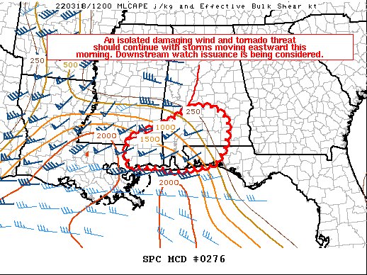
SUMMARY… An isolated severe wind and tornado threat should continue with storms moving eastward this morning. Downstream watch issuance is being considered.
DISCUSSION… A bowing line is progressing fairly quickly eastward across parts of southern/central AL this morning, aided by strong low-level warm advection associated with a 45-55 kt southerly low-level jet. Most of the line remains elevated as of 1215Z, with a continued lack of recent severe/damaging wind reports. Current expectations are for the southern part of the line (across mainly southern AL), and any discrete cells that can form ahead of it, to have the best potential for severe in the short term. Strong low-level shear remains favorable for updraft rotation, and any storms that can become surface based may pose a threat for tornadoes in addition to damaging winds. The main limiting factor still appears to be that the fast eastward progress of the ongoing convection is generally outpacing the more substantial low-level moisture return. Still, a couple of confluence bands have recently developed ahead of the line across far southern MS into coastal southern AL. This area should have the best chance for severe storms this morning as surface dewpoints increase into the mid to upper 60s. A downstream Tornado Watch is being considered for more of southern AL and parts of the western FL Panhandle.
Category: Alabama's Weather, ALL POSTS, Severe Weather
About the Author (Author Profile)
Scott Martin is an operational meteorologist, professional graphic artist, musician, husband, and father. Not only is Scott a member of the National Weather Association, but he is also the Central Alabama Chapter of the NWA president. Scott is also the co-founder of Racecast Weather, which provides forecasts for many racing series across the USA. He also supplies forecasts for the BassMaster Elite Series events including the BassMaster Classic.Subscribe
If you enjoyed this article, subscribe to receive more just like it.


