Latest Mesoscale Discussion — Watch Possible for Northeastern Parts of Area
Probability of Watch Issuance… 40 percent
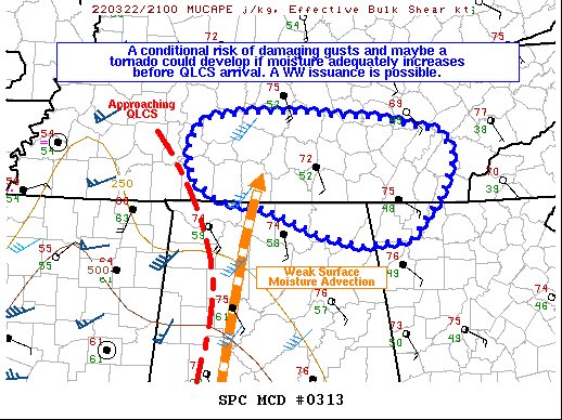
SUMMARY… A conditional severe threat may develop with the approaching squall line across southern-Middle Tennessee if adequate moisture can arrive on time. A couple of damaging gusts would be the main threat, though a tornado cannot be ruled out. A WW issuance is possible.
DISCUSSION… A mature QLCS with a history of damaging gusts and tornadoes is approaching portions of southern-Middle Tennessee. Ahead of the QLCS, temperatures are in the mid-70s F surface dewpoints, with dewpoints approaching 57 F. At the moment, buoyancy is scant ahead of the squall, and RAP forecast soundings suggest that dewpoints need to reach or exceed 59 F before convection can become sufficiently rooted in the surface-layer to ingest the abundant low-level streamwise vorticity to otherwise support a more appreciable severe threat. Latest surface observations have shown up to 59 F surface dewpoints across Lauderdale County, AL. As such, it is possible that enough surface-based buoyancy may advect ahead of the line into far southern-Middle TN to support the potential for a few damaging gusts and perhaps a tornado. Either way, conditions will continue to be monitored increasing buoyancy into TN and the need for a possible WW issuance.
Category: Alabama's Weather, ALL POSTS, Severe Weather
About the Author (Author Profile)
Scott Martin is an operational meteorologist, professional graphic artist, musician, husband, and father. Not only is Scott a member of the National Weather Association, but he is also the Central Alabama Chapter of the NWA president. Scott is also the co-founder of Racecast Weather, which provides forecasts for many racing series across the USA. He also supplies forecasts for the BassMaster Elite Series events including the BassMaster Classic.Subscribe
If you enjoyed this article, subscribe to receive more just like it.


