Latest Mesoscale Discussion — Tornado Watch Likely Within the Next Few Hours for Western Parts of the Area
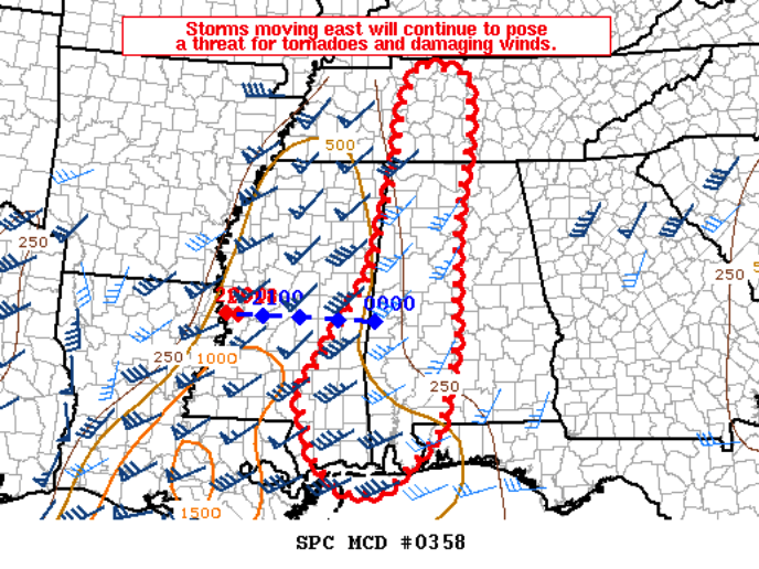
SPC will likely issue a Tornado Watch over the next few hours for counties just west of the I-65 corridor to the AL/MS state line. A mixture of strong shear and good helicity, along with rising instability, damaging winds will continue to be the main threat, but a few tornadoes will be possible.
SUMMARY… Storms will continue eastward through western Tennessee and much of Mississippi. A new watch will likely be needed for parts of Middle Tennessee and western Alabama within 1-3 hours.
DISCUSSION… Storms in southwestern/central Mississippi continue to move east. This portion of the line has shown a greater eastward motion than adjacent areas. With the low-level jet and mid-level forcing expected to increase into Alabama later this afternoon/evening, the environment ahead of this activity should remain favorable for scattered wind damage and tornadoes, particularly in portions of southern Mississippi into central/southern Alabama. Farther north into Middle Tennessee, buoyancy will be weaker, but strong wind fields and strong forcing for ascent should maintain the line now entering western Tennessee and northern Mississippi. A new watch will likely be needed within the next 1-3 hours.
Category: Alabama's Weather, ALL POSTS, Severe Weather
About the Author (Author Profile)
Scott Martin is an operational meteorologist, professional graphic artist, musician, husband, and father. Not only is Scott a member of the National Weather Association, but he is also the Central Alabama Chapter of the NWA president. Scott is also the co-founder of Racecast Weather, which provides forecasts for many racing series across the USA. He also supplies forecasts for the BassMaster Elite Series events including the BassMaster Classic.Subscribe
If you enjoyed this article, subscribe to receive more just like it.


