Mesoscale Discussion — A Severe Thunderstorm Watch May Be Needed for the Northeastern Parts of the Area
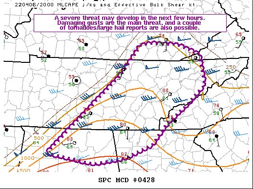
SUMMARY… A severe threat may develop with storms that initiate along a cold front, posing a threat for damaging gusts. A couple instances of severe hail/tornadoes are also possible.
DISCUSSION… Storms have struggled to develop within the warm sector environment 50-150 nautical miles ahead of the cold front despite ample diurnal heating and the presence of adequate buoyancy. However, storms have been developing along and immediately behind the cold front over the past hour. An uptick in storm coverage and intensity is possible over the next few hours as the cold front continues to progress eastward. The 500-1500 J/kg MLCAPE, driven by 60-65 F surface dewpoints and steep low-level lapse rates, along with 40+ kts of effective bulk shear suggest that damaging gusts may be the main threat with the more organized multicells/transient supercells that can develop. However, a few surface observations along a CHA to CPF line show some backing of the surface winds. Any storms that can mature amid these back winds may exhibit at least brief bouts of strong low-level rotation, with severe hail and a couple of tornadoes possible.
Probability of Watch Issuance…80 percent
Category: Alabama's Weather, ALL POSTS, Severe Weather
About the Author (Author Profile)
Scott Martin is an operational meteorologist, professional graphic artist, musician, husband, and father. Not only is Scott a member of the National Weather Association, but he is also the Central Alabama Chapter of the NWA president. Scott is also the co-founder of Racecast Weather, which provides forecasts for many racing series across the USA. He also supplies forecasts for the BassMaster Elite Series events including the BassMaster Classic.Subscribe
If you enjoyed this article, subscribe to receive more just like it.


