A Look at the Alabama Weather Situation at 5:30 p.m.
It’s been a beautiful day across Alabama with a good supply of sunshine, warm temperatures, and nice breezes. Those southerly winds have been averaging 15-20 mph and gusting to over 25 mph at times. It has not felt especially humid, but those dewpoints will be rising.
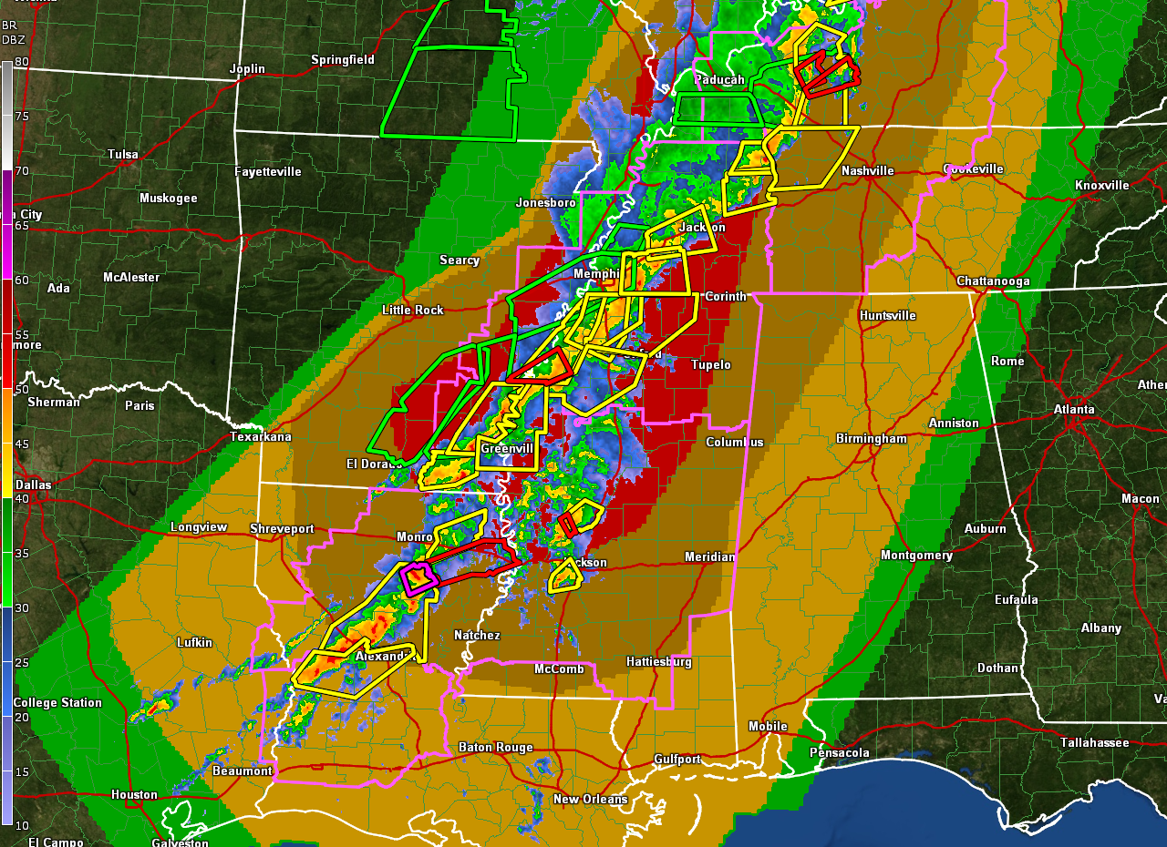
A strong cold front is over eastern Arkansas and northwestern Louisiana this afternoon. A long squall line extends all the way from southern Indiana through western Kentucky, western Tennessee into northwestern Mississippi, southeastern Arkansas, and Central Louisiana.
Winds gusted to 82 mph in Mississippi County, Arkansas as the storms passed there.
One bowing segment is moving across western Kentucky. The NWS Paducah has a tornado warning for areas between Madisonville and Hopkinsville. Tornado watches cover a lot of territory from western Kentucky through western Tennessee, the northern two thirds of Mississippi, all the way back to eastern Texas.
A nearly solid wall of severe thunderstorm warnings extends from Kentucky down into Louisiana. A confirmed tornado is south of Monroe LA. It is approaching Columbia LA.
The NWS in Shreveport is warning that storms along the line could produce winds of 80 mph in places.
In Central Mississippi, a tornado warning continues just south of Yazoo City. This storm is on a track that will carry it into western Alabama in a little over 3 hours.
The storms are expected to reach northwestern Alabama around 8 p.m. They should reach a line from Decatur to Jasper to Demopolis by 9-10 p.m. They should reach Tuscaloosa after 10 p.m. and Gadsden and Birmingham by 11:30 p.m.
The storms should reach Montgomery around 1 a.m.
The tornado threat in Alabama appears to be very small, but it is not zero, especially northwest of I-59 between 8-10 p.m. The main concern tonight is strong, potentially damaging straight line winds. Large hail is a possibility as well. The storms should weaken after midnight as the dynamic support fades, and instability values decrease.
Rain amounts tonight will be around one inch in most spots; for now major flooding issues are not expected.
Make sure to be weather aware tonight and have a reliable way of hearing severe weather warnings. And stay tuned to the AlabamaWX blog to get the latest severe weather information.
Category: Alabama's Weather, ALL POSTS
About the Author (Author Profile)
Bill Murray is the President of The Weather Factory. He is the site's official weather historian and a weekend forecaster. He also anchors the site's severe weather coverage. Bill Murray is the proud holder of National Weather Association Digital Seal #0001 @wxhistorianSubscribe
If you enjoyed this article, subscribe to receive more just like it.


