Severe Thunderstorm Watch May Need to Be Issued Over the Next Couple of Hours
Here is the latest Mesoscale Discussion text:
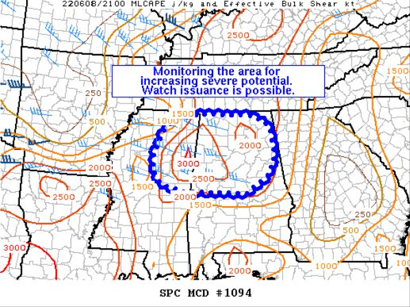
Concerning… Severe potential… Watch possible
Probability of Watch Issuance…40 percent
SUMMARY… The risk of locally severe gusts may increase across parts of northeast MS into northern AL during the next couple hours. Trends will continue to be monitored for possible watch issuance.
DISCUSSION… Ahead of a remnant MCS over parts of MS, a moist/unstable airmass is in place — characterized by lower 70s dewpoints and steep low-level lapse rates. While surface winds are generally weak/veered across northeast MS into northern AL, a modest increase in low/midlevel flow will be possible during the next couple hours as the remnant MCS continues tracking east-southeastward. The increasing flow (30-40 kt effective bulk shear) could support a few loosely organized multicell clusters capable of severe gusts and marginal hail as they spread eastward into the evening hours. It is somewhat unclear if the threat will warrant watch issuance, though trends are being monitored.
Category: Alabama's Weather, ALL POSTS, Severe Weather
About the Author (Author Profile)
Scott Martin is an operational meteorologist, professional graphic artist, musician, husband, and father. Not only is Scott a member of the National Weather Association, but he is also the Central Alabama Chapter of the NWA president. Scott is also the co-founder of Racecast Weather, which provides forecasts for many racing series across the USA. He also supplies forecasts for the BassMaster Elite Series events including the BassMaster Classic.Subscribe
If you enjoyed this article, subscribe to receive more just like it.


