Damaging Wind Gust Threat is Expected to Continue for a Few More Hours
From the Storm Prediction Center.
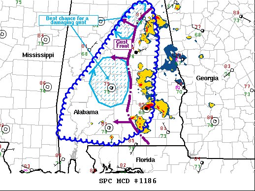
The severe weather threat for Severe Thunderstorm Watch 374
continues.
SUMMARY… The threat for damaging gusts is expected to persist for
at least a few more hours with the strongest parts of a westward
moving squall line.
DISCUSSION… A loosely organized MCS has become organized across
eastern AL and continues to progress westward. Despite earlier
storms causing some overturning of the ambient airmass and nocturnal
cooling, lower 80s F surface temperatures and lower 70s F dewpoints
are contributing to over 2000 J/kg MLCAPE (when modifying the 00Z
BMX observed soundings to match current local surface observations).
This observed sounding modification also depicts 1000+ J/kg
downdraft CAPE present in central AL. As such, the cold pool
associated with the MCS is expected to continue propagating westward
at a modest pace, with strong wind gusts likely all along the MCS
leading line. In areas that have yet to be convectively overturned
(i.e. areas around Etowah County and west of the city of Montgomery)
locally damaging, potentially severe gusts are most likely given the
presence of stronger convective cells, reinforcing cold pool
intensity. The damaging gust threat is expected to persist for at
least a few more hours.
Category: Alabama's Weather, ALL POSTS, Severe Weather
About the Author (Author Profile)
Scott Martin is an operational meteorologist, professional graphic artist, musician, husband, and father. Not only is Scott a member of the National Weather Association, but he is also the Central Alabama Chapter of the NWA president. Scott is also the co-founder of Racecast Weather, which provides forecasts for many racing series across the USA. He also supplies forecasts for the BassMaster Elite Series events including the BassMaster Classic.Subscribe
If you enjoyed this article, subscribe to receive more just like it.


