Very Warm with Scattered Showers Out There at Midday
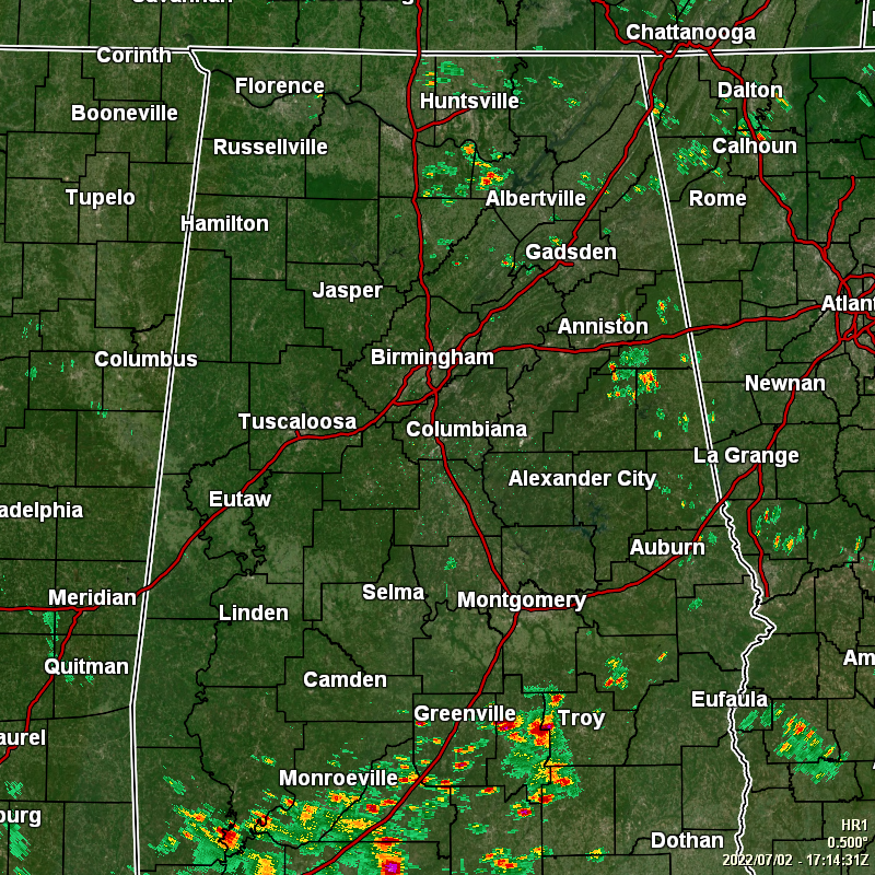
We are already seeing a decent bit of scattered showers and thunderstorms over the northern and eastern parts of the area, while the rest have partly to mostly sunny skies. Temperatures as of the 12 pm roundup were in the lower 80s to the lower 90s. The hot spot was Troy at 91º, while the cool spot was Auburn at 82º. Birmingham was sitting at 88º.
Scattered showers and thunderstorms will continue to develop during the afternoon and into the early evening hours, with rain chances being rather high, even though not everyone will see rain. Afternoon highs will reach the upper 80s to the lower 90s. Any thunderstorm activity should come to an end a little after sunset, with patchy fog developing later on. Lows will be in the lower 70s.
Sunday’s rain chances will continue to be rather high, as scattered to numerous showers and storms will develop with the main heating of the day. Once again, not everyone will see rain, but it is best to have a secondary plan if you have something outdoors scheduled. Afternoon highs will once again top out in the upper 80s to the lower 90s.
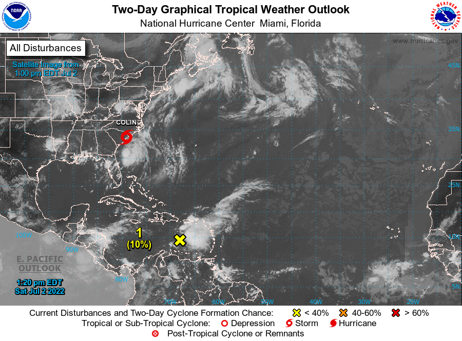
Tropical Storm Bonnie has made the crossover to the Eastern Pacific Ocean and is officially off of the map for the Atlantic Basin. It will continue to move west-northwestward, staying just south of the Mexican coast.
The center of Tropical Storm Colin (40 mph winds) remains just inland over eastern South Carolina at this point, but nearly all of the heavy rains and strong winds are off the coastline of South and North Carolina. Impending doom is in the future for Colin, as an approaching cold front will likely cause the circulation to become increasingly elongated tonight and Sunday, and the system is expected to dissipate or merge with the front by early Monday. Little change in intensity is expected prior to dissipation. Rough surf and rip currents are likely to continue along the North Carolina coast through Sunday. Areas of heavy rainfall may result in localized flash flooding across portions of coastal North Carolina through Sunday morning.
A tropical wave continues to produce disorganized showers and thunderstorms over the eastern Caribbean Sea, Puerto Rico, the Virgin Islands, and portions of the Leeward Islands. Although shower activity has increased a little today, significant development of this system is unlikely due to strong upper-level winds. This disturbance is expected to move westward to west-northwestward across the Caribbean Sea during the next few days.
* Formation chance through 48 hours… low… 10 percent.
* Formation chance through 5 days… low… 10 percent.
Category: Alabama's Weather, ALL POSTS, Tropical
About the Author (Author Profile)
Scott Martin is an operational meteorologist, professional graphic artist, musician, husband, and father. Not only is Scott a member of the National Weather Association, but he is also the Central Alabama Chapter of the NWA president. Scott is also the co-founder of Racecast Weather, which provides forecasts for many racing series across the USA. He also supplies forecasts for the BassMaster Elite Series events including the BassMaster Classic.Subscribe
If you enjoyed this article, subscribe to receive more just like it.


