Severe Thunderstorm Watch Cancelled for Jefferson/Shelby and Some Other Counties, Continues Ahead of Storms
The threat for damaging winds continues ahead of the squall line moving southward across Alabama tonight…
There were several reports of trees down across parts of the Birmingham Metro, including locations in Mountain Brook, Hoover, and Vestavia.
WATCH COUNTY NOTIFICATION FOR WATCH 451
NATIONAL WEATHER SERVICE BIRMINGHAM AL
723 PM CDT SAT JUL 9 2022
ALC073-115-100130-
/O.CAN.KBMX.SV.A.0451.000000T0000Z-220710T0300Z/
THE NATIONAL WEATHER SERVICE HAS CANCELLED SEVERE THUNDERSTORM
WATCH 451 FOR THE FOLLOWING AREAS
IN ALABAMA THIS CANCELS 2 COUNTIES
IN CENTRAL ALABAMA
JEFFERSON ST. CLAIR
THIS INCLUDES THE CITIES OF BIRMINGHAM, HOOVER, MOODY,
AND PELL CITY.
$$
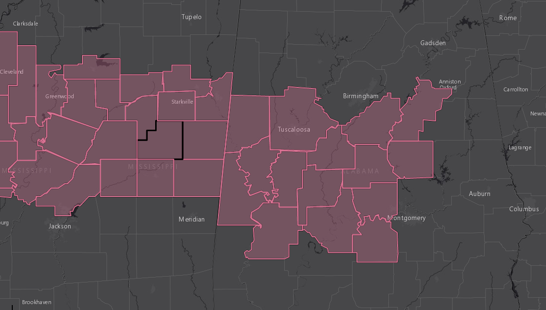
ALC001-007-021-037-047-063-065-085-091-105-107-117-119-121-125-
100300-
/O.CON.KBMX.SV.A.0451.000000T0000Z-220710T0300Z/
SEVERE THUNDERSTORM WATCH 451 REMAINS VALID UNTIL 10 PM CDT THIS
EVENING FOR THE FOLLOWING AREAS
IN ALABAMA THIS WATCH INCLUDES 15 COUNTIES
IN CENTRAL ALABAMA
AUTAUGA BIBB CHILTON
COOSA DALLAS GREENE
HALE LOWNDES MARENGO
PERRY PICKENS SHELBY
SUMTER TALLADEGA TUSCALOOSA
THIS INCLUDES THE CITIES OF ALABASTER, ALICEVILLE, BRENT,
CARROLLTON, CENTREVILLE, CLANTON, COLUMBIANA, DEMOPOLIS, EUTAW,
FORT DEPOSIT, GREENSBORO, LINDEN, LIVINGSTON, LOWNDESBORO,
MARION, MOUNDVILLE, PELHAM, PRATTVILLE, ROCKFORD, SELMA,
SYLACAUGA, TALLADEGA, TUSCALOOSA, UNIONTOWN, AND YORK.
Category: Alabama's Weather, ALL POSTS, Severe Weather
About the Author (Author Profile)
Bill Murray is the President of The Weather Factory. He is the site's official weather historian and a weekend forecaster. He also anchors the site's severe weather coverage. Bill Murray is the proud holder of National Weather Association Digital Seal #0001 @wxhistorianSubscribe
If you enjoyed this article, subscribe to receive more just like it.


