Wind & Hail Threat Continues for the Southwestern Parts of the Area
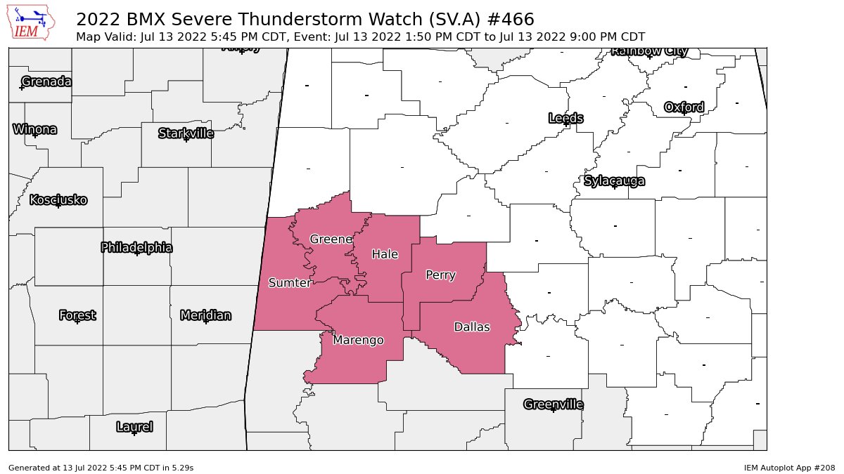
The threat for severe storms containing damaging winds and isolated hail will continue over the next few hours for the southwestern quarter of Central Alabama. At this point, the threat is over for Bibb, Tuscaloosa, and Pickens counties, and the Severe Thunderstorm Watch has been cancelled for those locations. The watch continues until 9 pm for Dallas, Greene, Hale, Marengo, Perry, and Sumter counties.
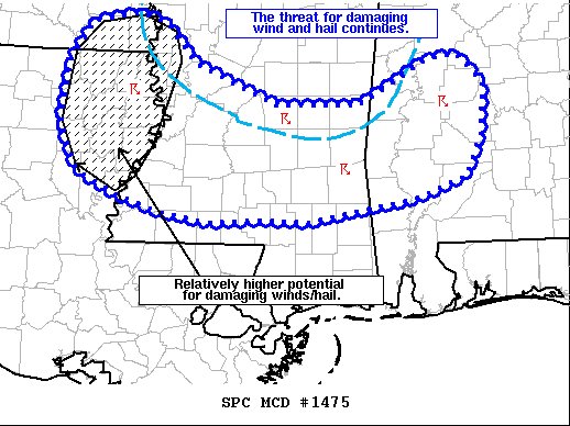
The severe weather threat for Severe Thunderstorm Watch 466
continues.
SUMMARY… The potential for damaging winds and sporadic large hail
will continue into the evening hours. A few storms may spread south
and west of WW 466, but the threat will most likely remain too
isolated for a downstream watch.
DISCUSSION… Thunderstorms continue to develop along and ahead of a
well-established cold pool/outflow boundary from northeast LA into
southern MS and western AL. Regional WSR-88D reflectivity and echo
top trends show that individual cell longevity has been limited –
likely owing to the meager deep-layer shear – but a few storms
continue to exhibit short bursts of intense convection (based on
GOES IR cloud-top trends). A few recent wind damage and hail reports
bear out this assessment.
Latest mesoanalysis estimates continue to show that the downstream
environment is largely uncapped with MLCAPE values between 2000-3000
J/kg. This environment will continue to support intense, but
short-lived convection as storms propagate to the south and west on
the leading edge of the cold pool. Wind damage and sporadic large
hail will continue to be the main hazards. This threat may be
maximized across parts of northeast LA over the next 1-2 hours where
instability is comparatively higher and low-level lapse rates remain
in excess of 8 C/km. Storms will likely propagate out of WW 466
through the evening hours, but the overall severe threat will most
likely remain fairly limited and preclude the need for a downstream
watch.
Category: Alabama's Weather, ALL POSTS, Severe Weather
About the Author (Author Profile)
Scott Martin is an operational meteorologist, professional graphic artist, musician, husband, and father. Not only is Scott a member of the National Weather Association, but he is also the Central Alabama Chapter of the NWA president. Scott is also the co-founder of Racecast Weather, which provides forecasts for many racing series across the USA. He also supplies forecasts for the BassMaster Elite Series events including the BassMaster Classic.Subscribe
If you enjoyed this article, subscribe to receive more just like it.


