Mesoscale Discussion — Severe Thunderstorm Watch Unlikely Due to Limited Storm Coverage
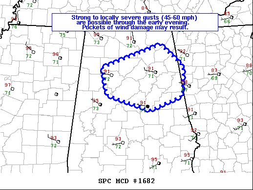
SUMMARY… Strong to locally severe gusts (45-60 mph) capable of pockets of wind damage are possible through the early evening. The limited coverage of damaging gusts will likely preclude the need for a small severe thunderstorm watch.
DISCUSSION… Visible-satellite and radar imagery shows a developing cluster of intensifying thunderstorms straddling I-65 in north-central AL as of 345pm CDT. The Birmingham 88D VAD shows westerly low-level flow veering to northerly and increasing into the 25-30 kt range in the 4-6 km layer. The mean wind will favor southeast storm motions with this activity moving into the Birmingham and Anniston areas over the next 1-2 hours. The airmass has become moderately unstable with lower 90s temperatures and dewpoints near 70 deg F. With 0-3 km lapse rates in excess of 8 deg C/km, water loading will be the primary mechanism for isolated wet microbursts.
Category: Alabama's Weather, ALL POSTS, Severe Weather
About the Author (Author Profile)
Scott Martin is an operational meteorologist, professional graphic artist, musician, husband, and father. Not only is Scott a member of the National Weather Association, but he is also the Central Alabama Chapter of the NWA president. Scott is also the co-founder of Racecast Weather, which provides forecasts for many racing series across the USA. He also supplies forecasts for the BassMaster Elite Series events including the BassMaster Classic.Subscribe
If you enjoyed this article, subscribe to receive more just like it.


