Some Flooding Issues May Continue for Several More Hours
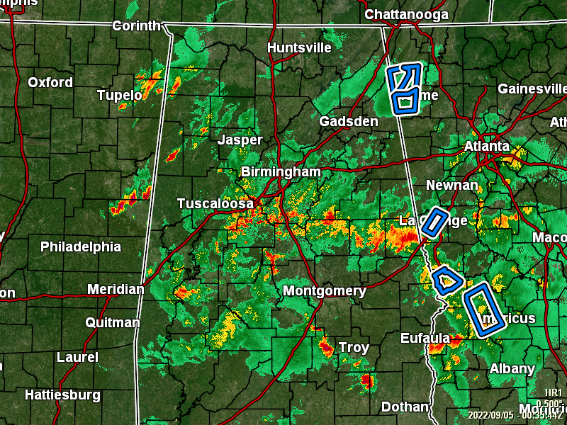
RADAR CHECK: As of 7:41 pm, much of North and Central Alabama are experiencing showers and thunderstorms, with some of these cells producing moderate to heavy rainfall which may lead to some flooding issues. While some places could see heavy amounts of rain over a few hours, the good news is that there is no threat of severe storms at this time. The bad news is that we will continue to have a threat of some flooding issues for the next 18 to 24 hours. All of the activity is moving to the northeast.
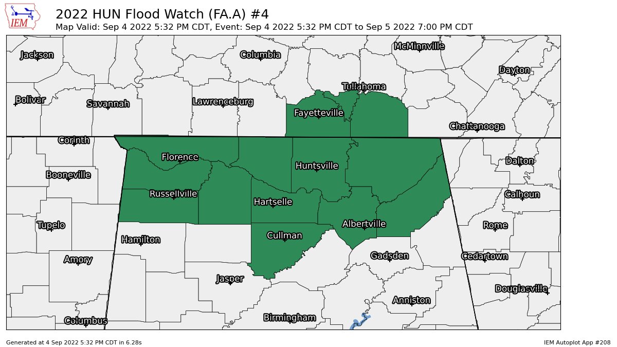
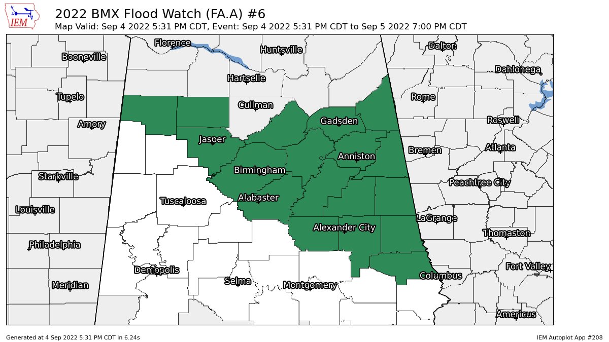
A Flood Watch continues until 7 pm Monday evening for Colbert, Cullman, DeKalb, Franklin, Jackson, Lauderdale, Lawrence, Limestone, Madison, Marshall, and Morgan counties in North Alabama, and for Blount, Calhoun, Chambers, Cherokee, Clay, Cleburne, Coosa, Etowah, Jefferson, Lee, Marion, Randolph, Shelby, St. Clair, Talladega, Tallapoosa, Walker, and Winston counties in Central Alabama
A Flood Advisory has just been extended for Jefferson County until 10 pm tonight.
A Flood Advisory continues for Shelby County until 10 pm tonight.
A Flood Advisory continues for Chambers County until 10:45 pm tonight.
LATEST FROM THE WPC:
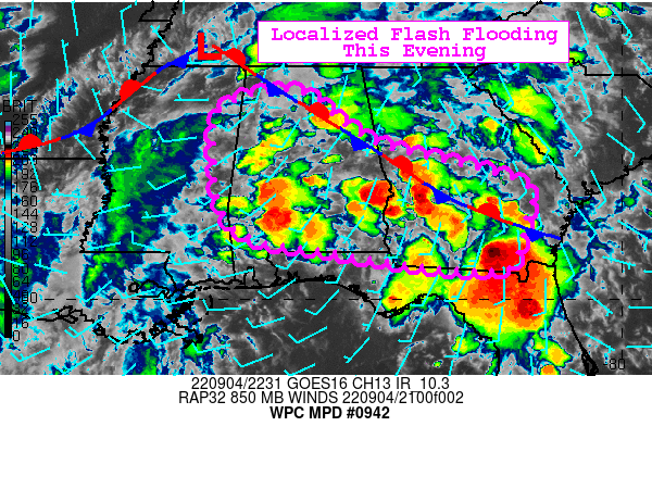
Summary… Scattered heavy thunderstorms could cause localized flash flooding this evening, particularly along a stationary front that stretches from northern Alabama to southern Georgia
Discussion… Southerly low level flow is feeding slow moving airmass thunderstorms across central/southern AL and southern GA early this evening and is converging along a stationary front over northern AL to southern GA. This front, oriented NW to SE is perpendicular to the southwesterly steering flow between a positively tilted trough axis over the Mid-South and a ridge axis off the Southeast coast.
2-2.5″ PW (2 standard deviations above normal) with ample instability of 2000-3000 J/kg SBCAPE has allowed particularly heavy rainfall to develop. Hourly rainfall estimates in the heaviest cells over west-central GA have been generally 2-2.5″, but cell mergers and some repetition, particularly near the front, should allow more exceedance of the 3hr flash flood guidance of 3-4″ (2.5-3″ in north-central AL).
Given the localized nature of the most repetition and heaviest cells, and that most of this interior area of the Southeast has been fairly dry over the past week, flash flooding is considered possible this evening and should remain fairly localized.
Category: Alabama's Weather, ALL POSTS
About the Author (Author Profile)
Scott Martin is an operational meteorologist, professional graphic artist, musician, husband, and father. Not only is Scott a member of the National Weather Association, but he is also the Central Alabama Chapter of the NWA president. Scott is also the co-founder of Racecast Weather, which provides forecasts for many racing series across the USA. He also supplies forecasts for the BassMaster Elite Series events including the BassMaster Classic.Subscribe
If you enjoyed this article, subscribe to receive more just like it.


