Sunday Weather Video: Some Drier Air Ahead
SHINE ON HARVEST MOON: Did you enjoy seeing a newly minted full moon last night. Accompanied by a brilliant Jupiter, they made quite a pair in the eastern sky during the evening hours.
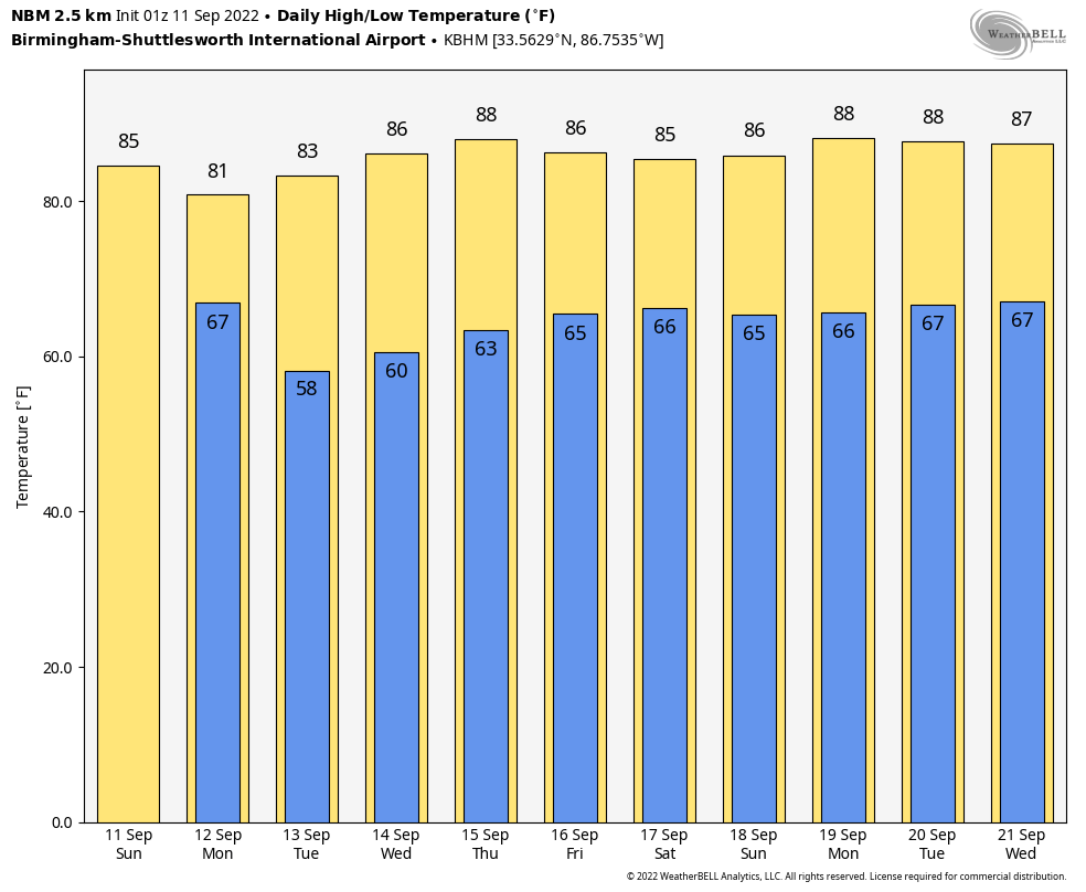
FOR YOUR SUNDAY: We have a deep upper trough across the Midwest this morning, with a surface low in Chicagoland. A cold front is approaching Alabama from the northwest. Skies will become mostly cloudy this morning and a few showers and storms will form ahead of the front. The cold front should reach Northwest Alabama by this evening, pushing southeastward overnight. Highs this afternoon will be in the lower and middle 80s. Lows tonight will be in the 60s.
THE WEEK AHEAD: The front will exit the state by Monday night. Dewpoints by Monday night will be in the 50s across North and Central Alabama. 50s will be common Tuesday and Wednesday mornings. We should be dry for the work week. Highs will be gradually edging up into the middle 80s as we go through the week. 60s will be in the offing for lows by Thursday into the weekend.
WEEKEND OUTLOOK: Partly cloudy skies, a slight chance of showers and storms again. Lows will be in the 60s. Highs will be in the 80s.
SIGN OF THE TIMES: Frost advisories are in effect this morning across parts of North Dakota as well as across southern Colorado. Denver is in the 40s this morning, but 20s are common in the mountains of Colorado.
TROPICS: With Earl becoming extratropical over the North Atlantic, the Basin appears that it will once again go quiet. It appears that nothing else will develop in the basin over the next7-10 days. Right outside of this main forecast period, the GFS and its ensemble members do support the development of something from a tropical wave that is currently over the eastern Atlantic once the system gets to near the Bahamas. That will be something worth watching, but it is a long way off. There have also been pretty consistent signals recently of something developing near the East Coast by next weekend, and of upcoming tropical mischief over the western Caribbean and possibly the Gulf of Mexico in about 10-12 days.
AND IN THE EASTERN PACIFIC: Kay was an interesting storm, passing about 250 miles miles southwest of San Diego, but bringing winds of over 100 mph to the mountains of San Diego County. A gust to 109 mph was measured at Cayumaca Peak, 9 miles south of Julian CA. San Diego picked up 0.60 inches of rain Friday, but up to 5 inches of rain fell in the mountains east of San Diego. The rains did help tamp down wildfires in parts of Southern California, which had earlier been aided by the winds in advance of Kay.
BEACHCAST: Rain chances will slowly decrease along the beautiful beaches of Alabama and Northwest Florida by Tuesday, with a couple of rain-free days Tuesday and Wednesday. Rain chance will creep back in by Thursday as an easterly flow returns to the coast. Highs will be in the upper 80s all week with lows in the lower 70s. Water temperatures are in the lower 80s.
Click here to see the Beach Forecast Center page.
DANCING WITH THE STATS: Record rainfall from a tropical storm and record heat on the same day? It happened at Los Angeles International Airport on Friday. The high of 102F smashed the record for the date of 96F. And the 0.13 inches of rain broke the previous record for the date of 0.01 inches.
ADVERTISE WITH US: Deliver your message to a highly engaged audience by advertising on the AlabamaWX.com website. The site enjoyed over 29 MILLION page views in the past 12 months. Don’t miss out! We can customize a creative, flexible, and affordable package that will suit your organization’s needs. Contact me, Bill Murray, at (205) 687-0782 and let’s talk.
WEATHERBRAINS: This week, the panel will entertain Krissy Hurley from the NWS in Nashville. We will be discussing the tragic Waverly flood that occurred in Middle Tennessee last year. Check out the show at www.WeatherBrains.com. You can also subscribe on iTunes. You can watch the show live at live.bigbrainsmedia.com or on James’ YouTube Channel You will be able to see the show on the James Spann 24×7 weather channel on cable or directly over the air on the dot 2 feed.
ON THIS DATE IN 2001: On September 10, 2001, a strong cold front had blown through New York City and strong high pressure was taking control of much of the United States. Blue skies greeted the day in New York City after strong thunderstorms had affected the city the night before. The World Trade Center towers had been struck by lightning six times that evening. The beautiful blue skies provided a shocking backdrop to the outpouring of black smoke from the stricken towers on the morning of September 11th. Follow my weather history tweets on Twitter. I am @wxhistorian at Twitter.com.
Category: Alabama's Weather, ALL POSTS, Weather Xtreme Videos
About the Author (Author Profile)
Bill Murray is the President of The Weather Factory. He is the site's official weather historian and a weekend forecaster. He also anchors the site's severe weather coverage. Bill Murray is the proud holder of National Weather Association Digital Seal #0001 @wxhistorianSubscribe
If you enjoyed this article, subscribe to receive more just like it.


