Sunday Weather Video: All Eyes on Ian
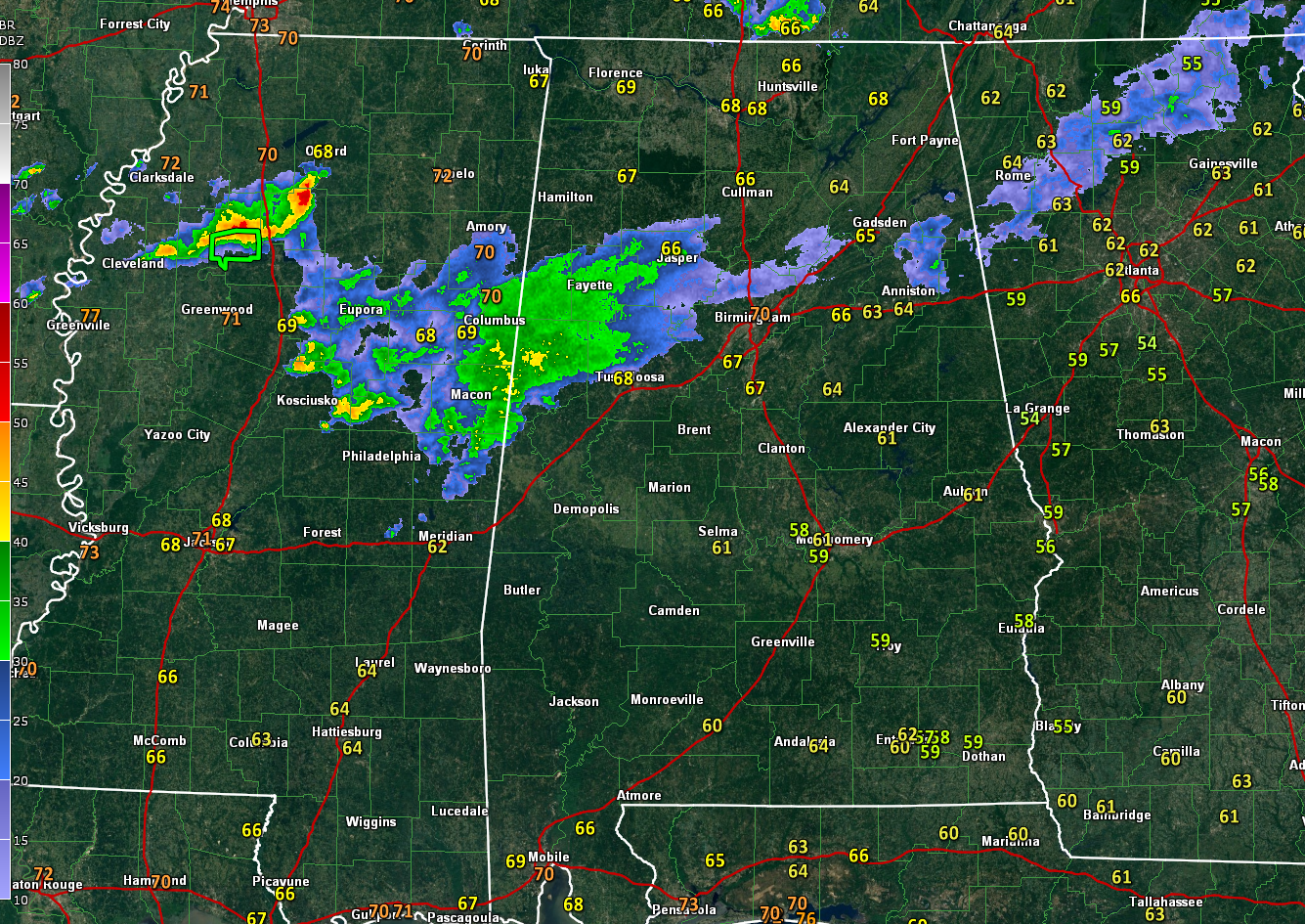
Showers and thunderstorms are on tap for today across Alabama ahead of a southward moving cold front that will play a big role in the future intensity of Ian if it moves into the northern Gulf of Mexico.
The storms are not strong at this time. A few of them could be a little on the strong side later this afternoon over Northeast Alabama and we note that the SPC does have a marginal risk (1/5) over extreme Northeast Alabama for later today. Damaging winds and hail would be the only threats.
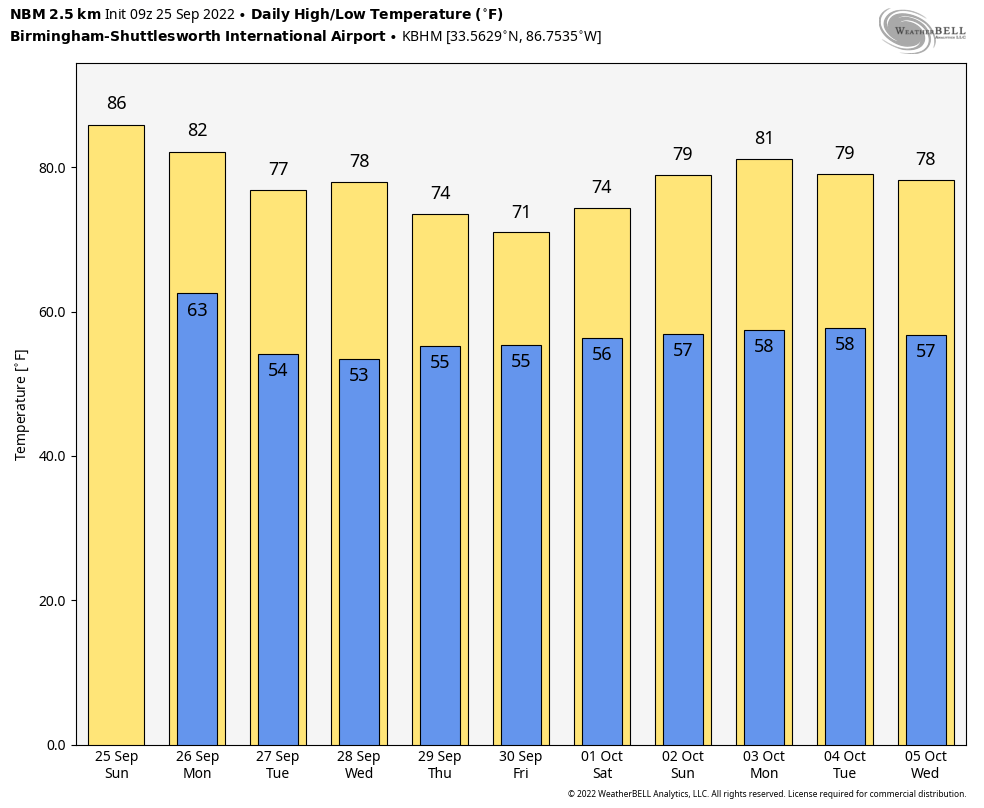
Drier and cooler air will move into Alabama from the north tonight through Tuesday and the result will be cooler nighttime readings in the 50s north of I-20 tonight and area-wide each morning the rest of the week. A few spots in North Alabama will be in the 40s some of the mornings. Highs will be in the lower 80s Monday and 70s the rest of the week.
THE LATEST ON IAN: Ian is still an organizing tropical storm this morning southwest of Jamaica with top winds of 50 mph. It is expected to begin intensifying later today and rapid intensification is possible. By tonight, it should be approaching hurricane status, about 150 miles south of the Cayman Islands, starting to move northwest. Tropical storm conditions are possible on the Caymans overnight and by morning it will be 125 miles southwest of George Town in the Caymans. By tomorrow evening it will be approaching the western tip of Cuba as a category three major hurricane with winds approaching 115 mph. Then it is into the Gulf of Mexico.
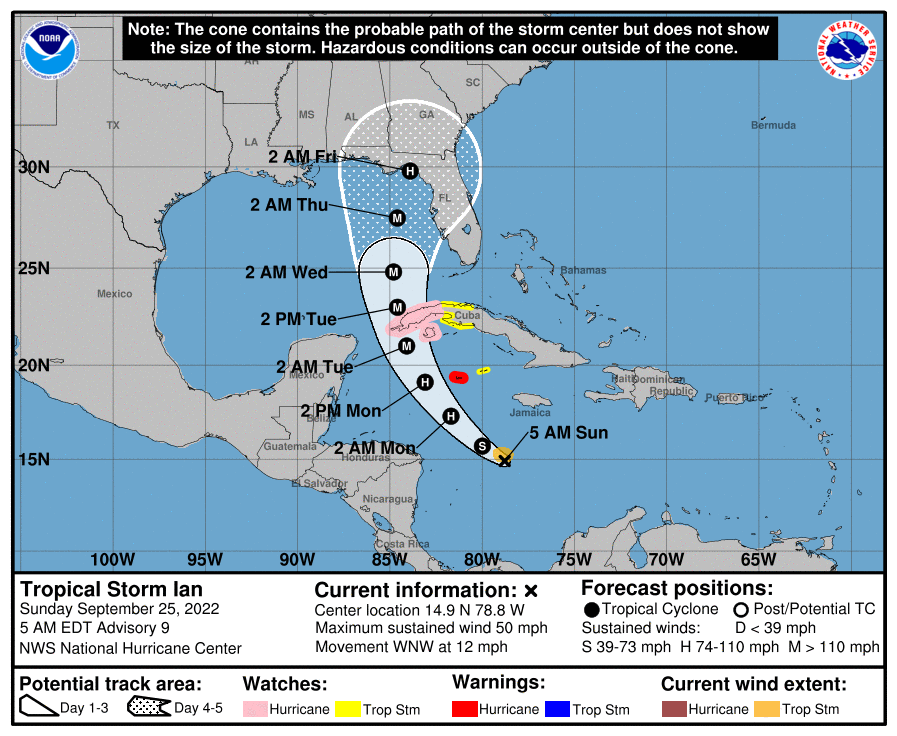
THEN WHERE IT GOES IS CRITICAL: Still lots of uncertainty with lots of spread in the models even after ingesting extra balloon data from NWS offices on Saturday and data from the GIV plane last evening. The GFS ensembles still show everything from New Orleans to Tampa in play, but the mean is into the northeastern Gulf of Mexico, east of Panama City and Apalachicola. That is where most of the other hurricane models are as well and where the official NHC track is. But the operational GFS is still near Destin by late Thursday and early Friday. Big difference if you have a place in Northwest Florida or have a trip planned.
GOOD NEWS IS: There will be very high wind shear and lots of dry air waiting for Ian if it comes north and the weakening will be pronounced if it chooses to come to the Panhandle. The NHC forecast drops it to 90 mph before landfall in the Big Bend. Still a formidable hurricane, but not one for the record books.
ROUGH OCEAN: Still, the ocean will become very rough along the beautiful beaches of Alabama and Northwest Florida by midweek, and while water temperatures will still be warm, don’t be tempted by the big waves to go in the water. Rip currents will turn deadly.
FOR ALABAMA: It will become breezy Tuesday and Wednesday as we feel the pressure gradient from the deep low to the south and high pressure to the north. Winds will gust to 20-25 mph at times. If the GFS Track materializes, rain and storms will spread northward from the coast Thursday with Friday prmising to be a wet day. If the more easterly track happens, we will be dry and pleasant all the way into a beautiful weekend. Stay tuned.
FREQUENT UPDATES: We will be tracking Ian’s every move and giving you the lowdown here on the blog all week long.
Category: Alabama's Weather, ALL POSTS, Severe Weather, Tropical
About the Author (Author Profile)
Bill Murray is the President of The Weather Factory. He is the site's official weather historian and a weekend forecaster. He also anchors the site's severe weather coverage. Bill Murray is the proud holder of National Weather Association Digital Seal #0001 @wxhistorianSubscribe
If you enjoyed this article, subscribe to receive more just like it.


