TS Ian Update: The Florida Keys Now Under a Tropical Storm Warning & a Storm Surge Watch
SUMMARY OF 1000 PM CDT…0300 UTC…INFORMATION
———————————————–
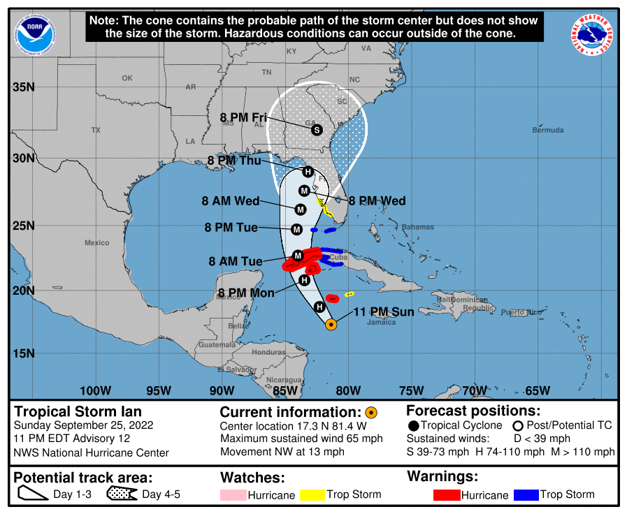
LOCATION…17.3 N, 81.4 W
ABOUT 140 MI…225 KM S OF GRAND CAYMAN
ABOUT 390 MI…630 KM SE OF THE WESTERN TIP OF CUBA
MAXIMUM SUSTAINED WINDS…65 MPH…100 KM/H
PRESENT MOVEMENT…NW OR 315 DEGREES AT 13 MPH…20 KM/H
MINIMUM CENTRAL PRESSURE…989 MB…29.21 INCHES
SUMMARY OF WATCHES AND WARNINGS IN EFFECT:
———————————————–
A Hurricane Warning is in effect for…
* Grand Cayman
* Cuban provinces of Isla de Juventud, Pinar del Rio, and Artemisa
A Tropical Storm Warning is in effect for…
* Cuban provinces of La Habana, Mayabeque, and Matanzas
* Lower Florida Keys from Seven Mile Bridge westward to Key West
* Dry Tortugas
A Storm Surge Watch is in effect for…
* Florida Keys from the Card Sound Bridge westward to Key West
* Dry Tortugas
* West coast of Florida from Englewood southward to the Card Sound Bridge
* Florida Bay
A Tropical Storm Watch is in effect for…
* Little Cayman and Cayman Brac
* Englewood southward to Chokoloskee
DISCUSSION AND OUTLOOK
———————————————–
At 1000 PM CDT (0300 UTC), the center of Tropical Storm Ian was located near latitude 17.3 North, longitude 81.4 West. Ian is moving toward the northwest near 13 mph (20 km/h). A turn toward the north-northwest is expected on Monday, followed by a northward motion on Tuesday with a slightly slower forward speed. On the forecast track, the center of Ian is expected to pass near or west of the Cayman Islands on Monday, and near or over western Cuba Monday night and early Tuesday. Ian will then emerge over the southeastern Gulf of Mexico on Tuesday.
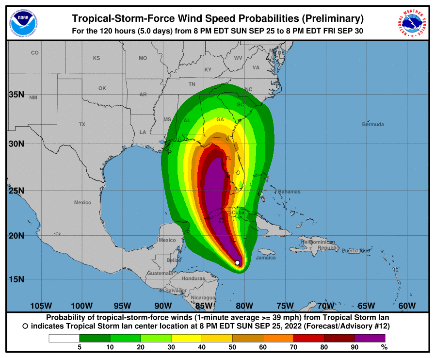
Maximum sustained winds have increased to near 65 mph (100 km/h) with higher gusts. Additional strengthening is forecast tonight, followed by more rapid strengthening on Monday and Tuesday. Ian is forecast to become a hurricane by early Monday and a major hurricane on Tuesday. Tropical-storm-force winds extend outward up to 70 miles (110 km) from the center. The minimum central pressure estimated from NOAA Hurricane Hunter observations is 989 mb (29.21 inches).
KEY MESSAGES
———————————————–
1. Ian is expected to produce heavy rainfall and instances of flash flooding and possible mudslides in areas of higher terrain, particularly over Jamaica and Cuba. Considerable flooding impacts are possible later this week in west central Florida. Additional flash and urban flooding, and flooding on rivers across the Florida Peninsula and parts of the Southeast, cannot be ruled out for later this week.
2. Life-threatening storm surge and hurricane-force winds are expected in portions of western Cuba beginning late Monday, and Ian is forecast to be at or near major hurricane strength when it is near western Cuba. Efforts to protect life and property should be rushed to completion.
3. Ian is expected to be a major hurricane in the eastern Gulf of Mexico during the middle of this week, but uncertainty in the track and intensity forecasts remains higher than usual. Regardless of Ian’s exact track and intensity, there is a risk of dangerous storm surge, hurricane-force winds, and heavy rainfall along the west coast of Florida and the Florida Panhandle by the middle of this week, and residents in Florida should ensure they have their hurricane plan in place. Follow any advice given by local officials and closely monitor updates to the forecast.
Category: ALL POSTS, Severe Weather, Tropical
About the Author (Author Profile)
Scott Martin is an operational meteorologist, professional graphic artist, musician, husband, and father. Not only is Scott a member of the National Weather Association, but he is also the Central Alabama Chapter of the NWA president. Scott is also the co-founder of Racecast Weather, which provides forecasts for many racing series across the USA. He also supplies forecasts for the BassMaster Elite Series events including the BassMaster Classic.Subscribe
If you enjoyed this article, subscribe to receive more just like it.


