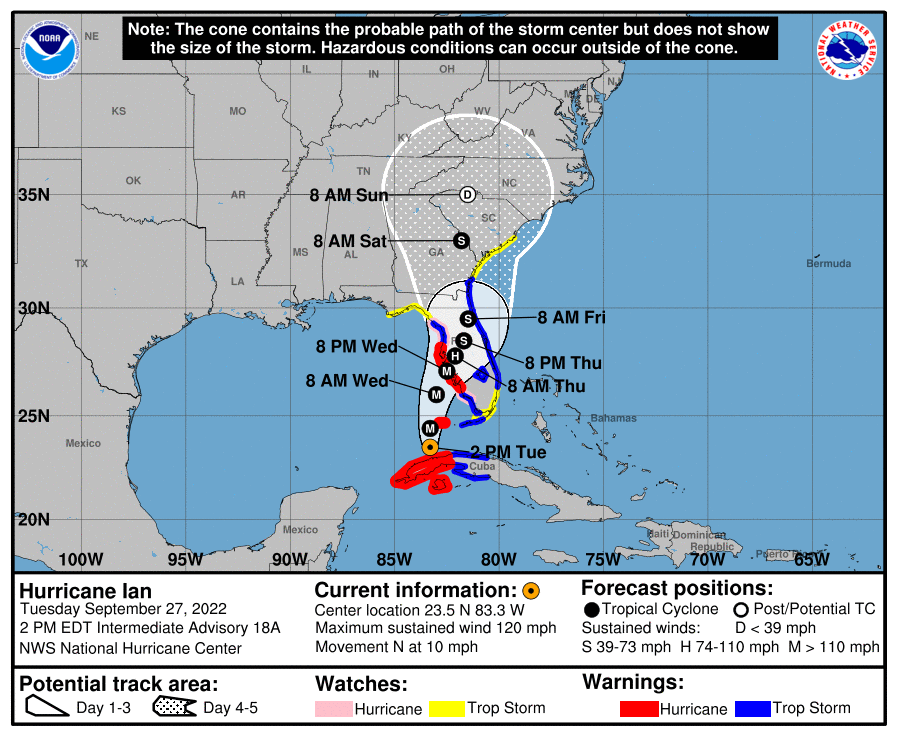
1 pm NHC Update: Ian Strengthening Over the Southeastern Gulf of Mexico
SUMMARY OF 100 PM CDT…1800 UTC…INFORMATION
———————————————-
LOCATION…23.5N 83.3W
ABOUT 265 MI…430 KM S OF SARASOTA FLORIDA
ABOUT 85 MI…140 KM SSW OF THE DRY TORTUGAS
MAXIMUM SUSTAINED WINDS…120 MPH…195 KM/H
PRESENT MOVEMENT…N OR 10 DEGREES AT 10 MPH…17 KM/H
MINIMUM CENTRAL PRESSURE…955 MB…28.20 INCHES
WATCHES AND WARNINGS
——————–
A Hurricane Warning is in effect for…
* Cuban provinces of Isla de Juventud, Pinar del Rio, and Artemisa
* Bonita Beach to Anclote River, including Tampa Bay
* Dry Tortugas
A Storm Surge Warning is in effect for…
* Suwanee River southward to Flamingo
* Tampa Bay
* Dry Tortugas
* Marineland to the mouth of the St. Mary’s River
* St. Johns River
A Tropical Storm Warning is in effect for…
* Cuban provinces of La Habana, Mayabeque, and Matanzas
* Suwannee River to the Anclote River
* Flamingo to Bonita Beach
* Lower and Middle Florida Keys
* Boca Raton to Altamaha Sound
* Lake Okeechobee
A Storm Surge Watch is in effect for…
* Florida Keys from the Card Sound Bridge westward to Key West
* Florida Bay
* Aucilla River to Suwanee River
* Mouth of St. Mary’s River to South Santee River
* South of Marineland to the Volusia/Flagler county line
A Hurricane Watch is in effect for…
* North of Anclote River to Suwannee River
* South of Bonita Beach to Chokoloskee
A Tropical Storm Watch is in effect for…
* North of Suwannee River to Indian Pass
* North of Altamaha Sound to South Santee River
* South of Boca Raton to east of Flamingo
* Upper Florida Keys
* Florida Bay
DISCUSSION AND OUTLOOK
———————-
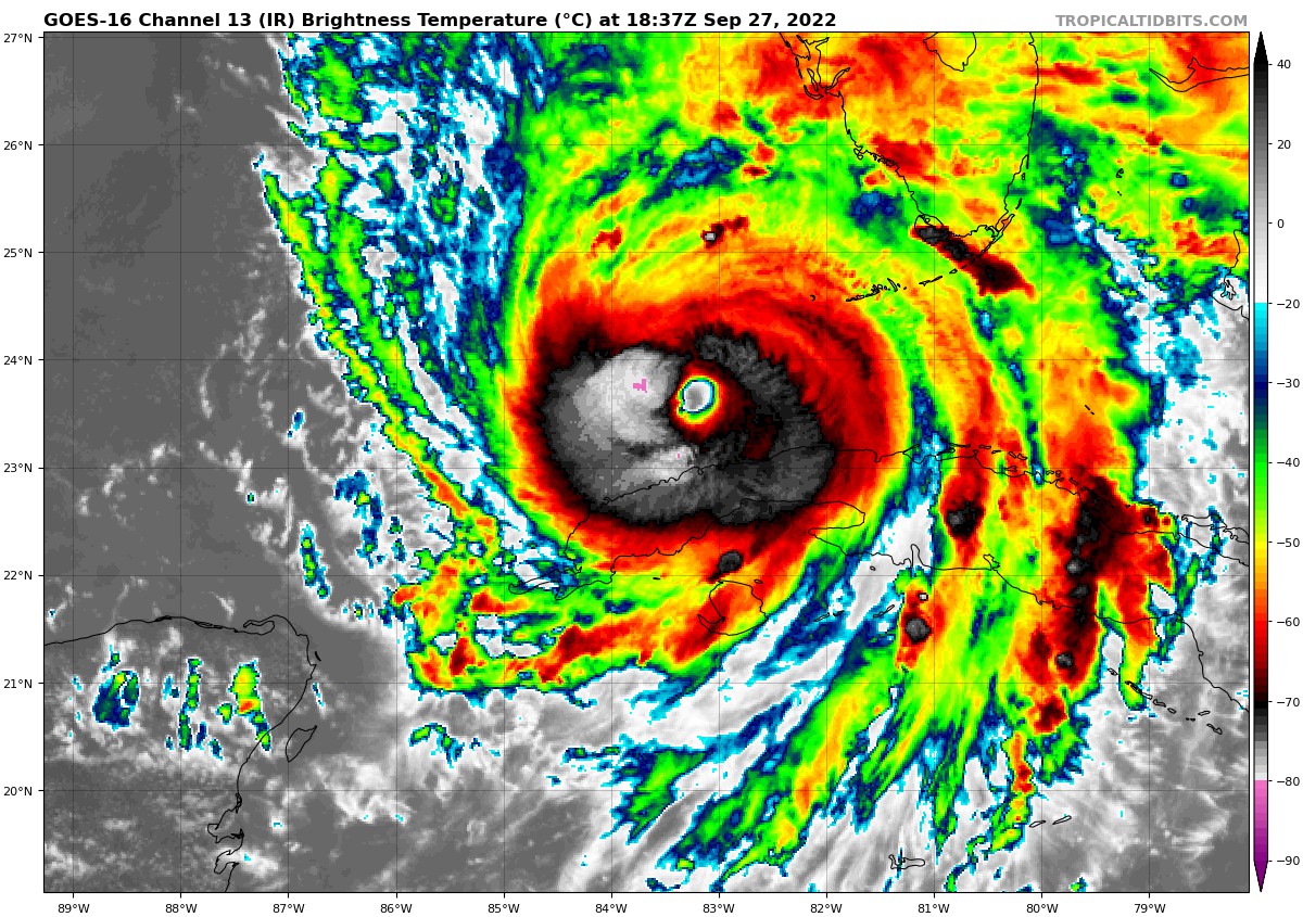
At 100 PM CDT (1800 UTC), the center of Hurricane Ian was located near latitude 23.5 North, longitude 83.3 West. Ian is moving toward the north near 10 mph (17 km/h), and this motion is expected to continue today. A turn toward the north-northeast with a reduction in forward speed is forecast tonight and Wednesday. On the forecast track, the center of Ian is expected to move over the southeastern Gulf of Mexico today, pass west of the Florida Keys later tonight, and approach the west coast of Florida within the hurricane warning area on Wednesday and Wednesday night.
Maximum sustained winds have increased to near 120 mph (195 km/h) with higher gusts. Ian is a category 3 hurricane on the Saffir-Simpson Hurricane Wind Scale. Re-strengthening is expected later today through Wednesday. Ian is forecast to approach the west coast of Florida as an extremely dangerous major hurricane. Hurricane-force winds extend outward up to 35 miles (55 km) from the center and tropical-storm-force winds extend outward up to 140 miles (220 km). The minimum central pressure has dropped to 955 mb (28.20 inches) based on Air Force Hurricane Hunter data.
KEY MESSAGES
————
1. Life-threatening storm surge, hurricane-force winds, flash floods and possible mudslides are expected to continue in portions of western Cuba today. Devastating wind damage is expected near the core of Ian.
2. Life-threatening storm surge looks increasingly likely along much of the Florida west coast where a storm surge warning is in effect, with the highest risk from Fort Myers to the Tampa Bay region. Residents in these areas should listen to advice given by local officials and follow evacuation orders if made for your area.
3. Hurricane-force winds are expected in the hurricane warning area in southwest and west-central Florida beginning Wednesday morning with tropical storm conditions expected by this evening. Residents should rush all preparations to completion today.
4. Heavy rainfall will increase across the Florida Keys and south Florida today, spreading into central and northern Florida tonight and Wednesday, into the Southeast U.S. by Thursday and Friday, likely causing flash, urban, and small stream flooding. Considerable flooding is expected across central Florida into southern Georgia and coastal South Carolina, with widespread, prolonged moderate to major river flooding expected across central Florida.
Category: ALL POSTS, Severe Weather, Tropical
About the Author (Author Profile)
Scott Martin is an operational meteorologist, professional graphic artist, musician, husband, and father. Not only is Scott a member of the National Weather Association, but he is also the Central Alabama Chapter of the NWA president. Scott is also the co-founder of Racecast Weather, which provides forecasts for many racing series across the USA. He also supplies forecasts for the BassMaster Elite Series events including the BassMaster Classic.Subscribe
If you enjoyed this article, subscribe to receive more just like it.


