7 am NHC Update: Ian Near to Category 5 Strength
SUMMARY OF 800 AM EDT…1200 UTC…INFORMATION
———————————————-
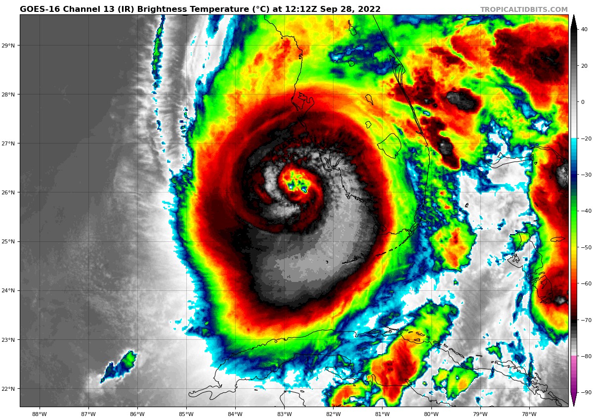
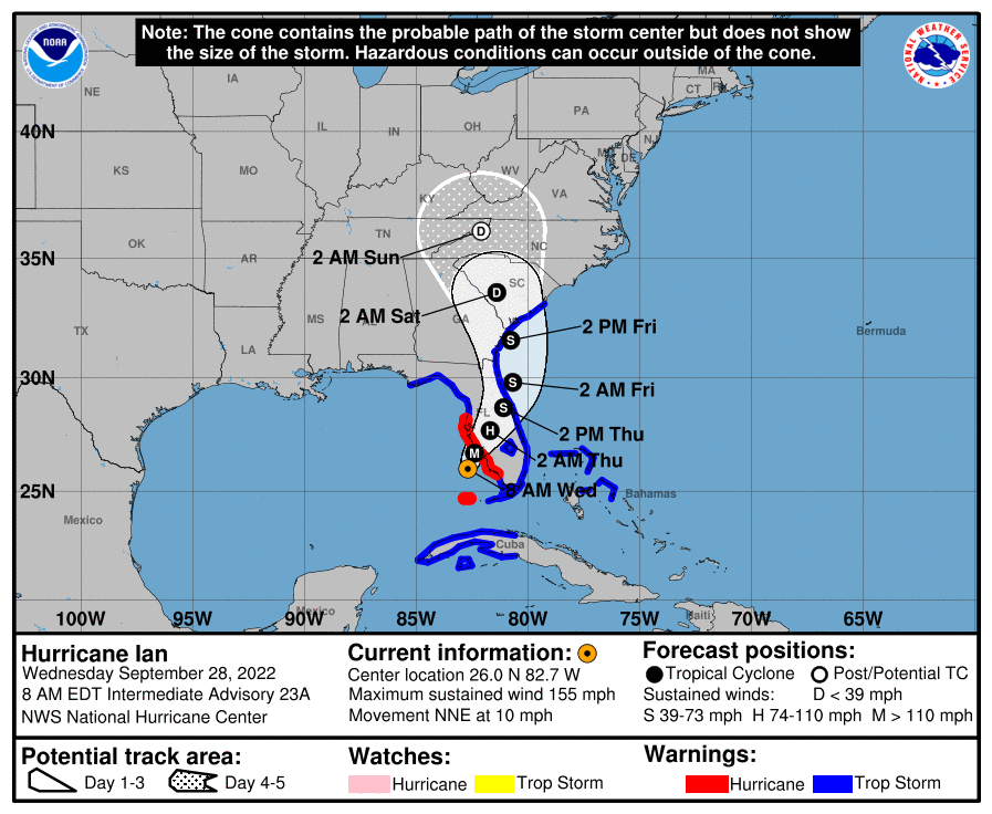
LOCATION…26.0N 82.7W
ABOUT 55 MI…90 KM W OF NAPLES FLORIDA
ABOUT 60 MI…100 KM SW OF PUNTA GORDA FLORIDA
MAXIMUM SUSTAINED WINDS…155 MPH…250 KM/H
PRESENT MOVEMENT…NNE OR 15 DEGREES AT 10 MPH…17 KM/H
MINIMUM CENTRAL PRESSURE…937 MB…27.67 INCHES
WATCHES AND WARNINGS
——————–
A Hurricane Warning is in effect for…
* Chokoloskee to Anclote River, including Tampa Bay
* Dry Tortugas
A Storm Surge Warning is in effect for…
* Suwannee River southward to Flamingo
* Tampa Bay
* Lower Florida Keys from Big Pine Key westward to Key West
* Dry Tortugas
* Flagler/Volusia Line to the mouth of the St. Mary’s River
* St. Johns River
A Tropical Storm Warning is in effect for…
* Cuban provinces of La Habana, Mayabeque, and Matanzas
* Indian Pass to the Anclote River
* All of the Florida Keys
* Flamingo to South Santee River
* Flamingo to Chokoloskee
* Lake Okeechobee
* Florida Bay
* Bimini and Grand Bahama Islands
A Storm Surge Watch is in effect for…
* Florida Keys from the Card Sound Bridge westward to east of Big Pine Key
* Florida Bay
* Mouth of St. Mary’s River to South Santee River
DISCUSSION AND OUTLOOK
———————-
At 800 AM EDT (1200 UTC), the eye of Hurricane Ian was located by Air Force and NOAA Hurricane Hunter data plus Key West radar near latitude 26.0 North, longitude 82.7 West. Ian is moving toward the north-northeast near 10 mph (17 km/h). This general motion with a reduction in forward speed is forecast today, followed by a turn toward the north on Thursday. On the forecast track, the center of Ian is expected to move onshore within the hurricane warning area later this morning or early afternoon. The center of Ian is forecast to move over central Florida tonight and Thursday morning and emerge over the western Atlantic by late Thursday.
Maximum sustained winds remain near 155 mph (250 km/h) with higher gusts. Ian is a category 4 hurricane on the Saffir-Simpson Hurricane Wind Scale. Ian is forecast to make landfall on the west coast of Florida as a catastrophic hurricane. Weakening is expected after landfall. Hurricane-force winds extend outward up to 40 miles (65 km) from the center and tropical-storm-force winds extend outward up to 175 miles (280 km). The minimum central pressure is 937 mb (27.67 inches) based on Air Force Hurricane Hunter dropsonde data.
HAZARDS AFFECTING LAND
———————-
STORM SURGE: The combination of storm surge and the tide will cause normally dry areas near the coast to be flooded by rising waters moving inland from the shoreline. The water could reach the following heights above ground somewhere in the indicated areas if the peak surge occurs at the time of high tide…
* Englewood to Bonita Beach, including Charlotte Harbor…12-16 ft
* Middle of Longboat Key to Englewood… 6-10 ft
* Bonita Beach to Chokoloskee…7-11 ft
* Anclote River to Middle of Longboat Key, including Tampa Bay…4-6 ft
* Chokoloskee to East Cape Sable…4-7 ft
* Suwannee River to Anclote River…3-5 ft
* Lower Keys from Key West to Big Pine Key, including the Dry Tortugas…3-5 ft
* Flagler/Volusia County Line to Savannah River including St. Johns River…3-5 ft
* St. Johns River south of Julington…2-4 ft
* Savannah River to South Santee River…2-4 ft
* East Cape Sable to Card Sound Bridge…2-4 ft
* Florida Keys east of Big Pine Key…2-4 ft
* Patrick Air Force Base to Flagler/Volusia County Line…1-3 ft
* Indian Pass to Suwanee River…1-3 ft
WIND: Catastrophic wind damage is likely where the core of Ian moves onshore. Hurricane conditions will begin along the west coast of Florida within the Hurricane Warning area later this morning, with tropical storm conditions beginning before daybreak.
Tropical storm conditions are occurring in the warning area in the Florida Keys, and will continue this morning. Tropical storm conditions are expected in the warning area on the east coast of Florida beginning today, and should spread up the Georgia and South Carolina coasts tonight and Thursday. Tropical storm conditions are expected within the warning area in Cuba for the next few hours.
RAINFALL: Ian is expected to produce the following storm total rainfall:
* Florida Keys and South Florida: 6 to 8 inches, with local maxima up to 12 inches.
* Central and Northeast Florida: 12 to 18 inches, with local maxima up to 24 inches.
* Eastern Georgia and Coastal South Carolina: 4 to 8 inches, with local maxima of 12 inches.
Widespread, life-threatening catastrophic flash, urban, and river flooding is expected across central Florida. Widespread considerable flash, urban, and river flooding is expected across portions of southern Florida through Wednesday, and northeast Florida, southeastern Georgia, and coastal South Carolina later this week through the weekend. Limited flash, urban, and river flooding is possible over portions of the Southeast and southern Mid-Atlantic later this week through the weekend.
TORNADOES: Tornadoes are possible today and tonight across central and south Florida.
SURF: Swells generated by Ian are affecting the northern coast of Cuba, the northeastern coast of the Yucatán peninsula and west coast of Florida. Swells will increase along the east coast of Florida, Georgia, and South Carolina tonight and Thursday. These swells are likely to cause life-threatening surf and rip current conditions. Please consult products from your local weather office.
Category: ALL POSTS, Severe Weather, Tropical
About the Author (Author Profile)
Scott Martin is an operational meteorologist, professional graphic artist, musician, husband, and father. Not only is Scott a member of the National Weather Association, but he is also the Central Alabama Chapter of the NWA president. Scott is also the co-founder of Racecast Weather, which provides forecasts for many racing series across the USA. He also supplies forecasts for the BassMaster Elite Series events including the BassMaster Classic.Subscribe
If you enjoyed this article, subscribe to receive more just like it.


