Midday Nowcast: Phenomenal Fall Weather; Cat 4 Hurricane Ian Nearing Landfall

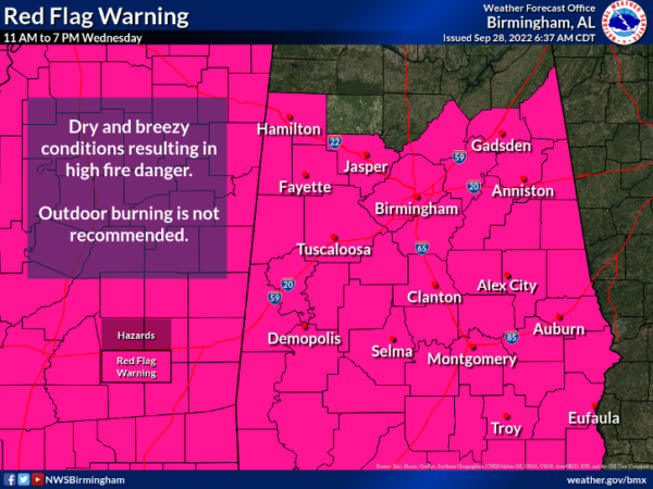
Tons of sunshine and breezy conditions will highlight the forecast for Alabama the rest of this week. Daytime temperatures will be in the 70s, and overnight lows in the 40s and 50s. Just incredibly beautiful weather to end the month of September in Alabama. We continue to have a Red Flag Warning across Alabama today as the combination of breezy conditions and very low humidity have increased our wildfire dangers. Please no outdoor burning!!!
HURRICANE IAN: At 1100 AM EDT, the eye of Hurricane Ian was located near latitude 26.3 North, longitude 82.5 West. Ian is moving toward the north-northeast near 9 mph. This general motion with a reduction in forward speed is forecast today, followed by a turn toward the northeast on Thursday. On the forecast track, the center of Ian is expected to move onshore within the hurricane warning area in a few hours, move over central Florida tonight and Thursday morning and emerge over the western Atlantic by late Thursday. Ian is forecast to turn northward on Friday and approach the northeastern Florida, Georgia and South Carolina coasts late Friday.
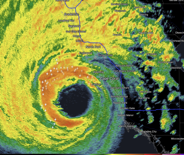
Maximum sustained winds remain near 155 mph with higher gusts. Ian is a category 4 hurricane on the Saffir-Simpson Hurricane Wind Scale. Ian is forecast to make landfall on the west coast of Florida as a catastrophic hurricane. Weakening is expected after landfall, but Ian could be near hurricane strength when it moves over the Florida East coast tomorrow, and when it approaches the northeastern Florida, Georgia and South Carolina coasts late Friday.
Hurricane-force winds extend outward up to 45 miles from the center and tropical-storm-force winds extend outward up to 175 miles. A Weatherflow station on Sanibel Island recently reported sustained winds of 58 mph with a gust to 75 mph. The estimated minimum central pressure is 937 mb (27.67 inches).
WONDERFUL WEEKEND WEATHER: The rain shield associated with Ian will stay east of Alabama. Some rain is possible Saturday near the Georgia border, but most of the state will be dry with a partly to mostly sunny sky…the high will be in the mid to upper 70s with a northerly breeze. Sunday will be another dry day with a high in the mid 70s.
FOOTBALL WEATHER: For the high school games in the state Friday night, the weather looks dry with temperatures falling through the 60s.
Saturday, Alabama travels to Fayetteville to take on Arkansas (2:30p CT kickoff)… the sky will be sunny with temperatures in the low 80s as the game begins. No risk of rain.
Auburn hosts LSU Saturday evening (6:00p CT kickoff) at Jordan-hare Stadium. Just a small risk of some light rain; the sky will be mostly cloudy with temperatures falling from near 75 at kickoff, into the upper 60s by the final whistle.
UAB will be in Houston to take on Rice (6:30p CT kickoff)… the sky will be clear with temperatures falling from the low 80s at kickoff into the mid 70s by the final whistle.
RACE WEEKEND: Just a small risk of a shower at Talladega Saturday, otherwise it will be a partly sunny day with a high between 75 and 78 degrees. Sunday is looking dry with a partly sunny sky along with a high in the mid 70s. The big rain shield associated with Ian will stay east of Alabama.
NEXT WEEK: The first week of October will be a dry one for Alabama as the great fall weather continues. Expect mostly sunny days and fair nights. Highs near 80° each day; lows in the upper 50s and low 60s most mornings. October is statistically Alabama’s driest month, and that looks to hold true this year.
BEACH FORECAST CENTER: Get the latest weather and rip current forecasts for the beaches from Fort Morgan to Panama City on our Beach Forecast Center page. There, you can select the forecast of the region that you are interested in visiting.
WORLD TEMPERATURE EXTREMES: Over the last 24 hours, the highest observation outside the U.S. was 113.2F at Jeddah King Abdul Aziz International Airport, Saudi Arabia. The lowest observation was -87.0F at Amundsen-Scott South Pole Station, Antarctica.
CONTIGUOUS TEMPERATURE EXTREMES: Over the last 24 hours, the highest observation was 112F at Death Valley, CA. The lowest observation was 21F at Mackay, ID.
Category: Alabama's Weather, ALL POSTS
About the Author (Author Profile)
Macon, Georgia Television Chief Meteorologist, Birmingham native, and long time Contributor on AlabamaWX. Stormchaser. I did not choose Weather, it chose Me. College Football Fanatic. @Ryan_StinnetSubscribe
If you enjoyed this article, subscribe to receive more just like it.


