7 pm NHC Update: Ian Down to Category 3; Continues to Batter the Florida Peninsula
IAN CONTINUING TO BATTER THE FLORIDA PENINSULA WITH CATASTROPHIC STORM SURGE, WINDS, AND FLOODING.
SUMMARY OF 800 PM EDT…0000 UTC…INFORMATION
———————————————-
LOCATION…27.2N 81.7W
ABOUT 30 MI…50 KM NE OF PUNTA GORDA FLORIDA
ABOUT 95 MI…150 KM SSW OF ORLANDO FLORIDA
MAXIMUM SUSTAINED WINDS…115 MPH…185 KM/H
PRESENT MOVEMENT…NNE OR 20 DEGREES AT 8 MPH…13 KM/H
MINIMUM CENTRAL PRESSURE…960 MB…28.35 INCHES
WATCHES AND WARNINGS
——————–
A Hurricane Warning is in effect for…
* Chokoloskee to Anclote River, including Tampa Bay
* Sebastian Inlet to Flagler/Volusia County Line
A Storm Surge Warning is in effect for…
* Suwannee River southward to Flamingo
* Tampa Bay
* Flagler/Volusia Line to the mouth of the South Santee River
* St. Johns River
A Tropical Storm Warning is in effect for…
* Indian Pass to the Anclote River
* Flamingo to Sebastian Inlet
* Flagler/Volusia County Line to Surf City
* Flamingo to Chokoloskee
* Lake Okeechobee
* Bimini and Grand Bahama Islands
A Storm Surge Watch is in effect for…
* North of South Santee River to Little River Inlet
* Florida Bay
A Hurricane Watch is in effect for…
* Flagler/Volusia County Line to the South Santee River
* Lake Okeechobee
A Tropical Storm Watch is in effect for…
* North of Surf City to Cape Lookout
DISCUSSION AND OUTLOOK
———————-
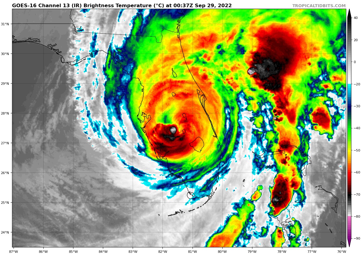
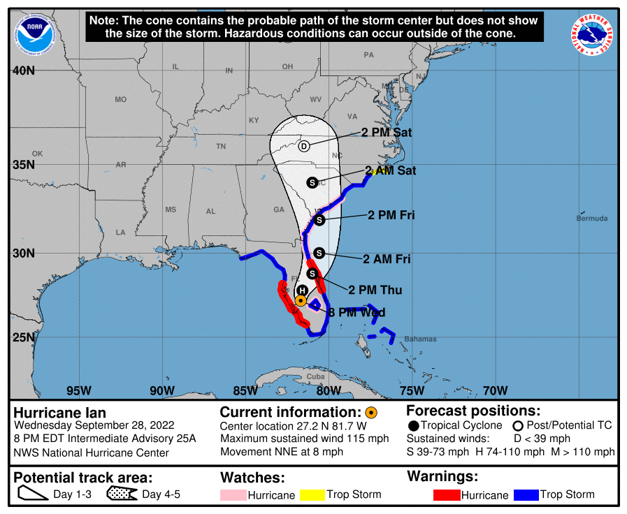
At 800 PM EDT (0000 UTC), the eye of Hurricane Ian was located near latitude 27.2 North, longitude 81.7 West. Ian is moving toward the north-northeast near 8 mph (13 km/h). On the forecast track, the center of Ian is expected to move across central Florida tonight and Thursday morning and emerge over the western Atlantic by late Thursday. Ian is forecast to turn northward on Friday and approach the northeastern Florida, Georgia and South Carolina coasts.
Maximum sustained winds have decreased to near 115 mph (185 km/h) with higher gusts. Ian is a category 3 hurricane on the Saffir-Simpson Hurricane Wind Scale. Further weakening is expected for the next day or so, but Ian could be near hurricane strength when it moves over the Florida East coast tomorrow, and when it approaches the northeastern Florida, Georgia and South Carolina coasts on Friday.
Hurricane-force winds extend outward up to 50 miles (85 km) from the center and tropical-storm-force winds extend outward up to 175 miles (280 km). A University of Florida Coastal Monitoring Program wind tower near Punta Gorda recently reported sustained winds of 54 mph (87 km/h) with a gust to 91 mph (146 km/h). A private weather station in Joshua recently measured a wind gust to 89 mph (143 km/h). The estimated minimum central pressure is 960 mb (28.35 inches).
HAZARDS AFFECTING LAND
———————-
STORM SURGE: The combination of storm surge and the tide will cause normally dry areas near the coast to be flooded by rising waters moving inland from the shoreline. The water could reach the following heights above ground somewhere in the indicated areas if the peak surge occurs at the time of high tide…
* Englewood to Bonita Beach, including Charlotte Harbor…12-18 ft
* Middle of Longboat Key to Englewood…6-10 ft
* Bonita Beach to Chokoloskee…8-12 ft
* Chokoloskee to East Cape Sable…5-8 ft
* Anclote River to Middle of Longboat Key, including Tampa Bay…4-6 ft
* Flagler/Volusia County Line to Altamaha Sound…4-6 ft
* Altamaha Sound to South Santee River…3-5 ft
* Suwannee River to Anclote River…3-5 ft
* St. Johns River north of Julington…3-5 ft
* St. Johns River south of Julington…2-4 ft
* East Cape Sable to Card Sound Bridge…2-4 ft
* South Santee River to Little River Inlet…2-4 ft
* Patrick Air Force Base to Flagler/Volusia County Line…1-3 ft
* East of Little River Inlet to Cape Lookout…1-3 ft
* Dry Tortugas and Florida Keys…1-3 ft
The deepest water will occur along the immediate coast near and to the right of the center, where the surge will be accompanied by large waves. Surge-related flooding depends on the relative timing of the surge and the tidal cycle, and can vary greatly over short distances. For information specific to your area, please see products issued by your local National Weather Service forecast office.
WIND: Catastrophic wind damage is likely near the core of Ian. Hurricane conditions are ongoing within the Hurricane Warning area now and will slowly spread northeastward through the night.
Hurricane conditions are expected to begin along the east coast of Florida in the Hurricane Warning area starting early Thursday. Hurricane conditions are possible in the Hurricane Watch area on Thursday through late Friday.
Tropical storm conditions are occurring in parts of the warning area on the east coast of Florida and should spread northward through the northeast Florida, Georgia and South Carolina coasts tonight and Thursday. Tropical storm conditions are possible in the Tropical Storm Watch area starting on Friday.
RAINFALL: Ian is expected to produce the following storm total rainfall:
* Florida Keys and South Florida: 6 to 8 inches, with local maxima up to 12 inches.
* Central and Northeast Florida: 12 to 20 inches, with local maxima up to 30 inches.
* Coastal Georgia and Lowcountry of South Carolina: 4 to 8 inches, with local maxima of 12 inches.
* Eastern Georgia and Coastal South Carolina: 3 to 6 inches, with local maxima of 8 inches across western North Carolina
Widespread, life-threatening catastrophic flash and urban flooding, with major to record flooding along rivers, is expected to continue across central Florida. Widespread considerable flash, urban, and river flooding is expected across portions of northeast Florida, southeastern Georgia, and eastern South Carolina later this week through the weekend. Locally considerable flash flooding, urban, and river flooding is possible this weekend across portions of the southern Appalachians with limited flooding possible across portions of southern Mid-Atlantic.
TORNADOES: A few tornadoes are possible this evening into tonight across east central Florida.
SURF: Swells generated by Ian are affecting the northern coast of Cuba, the northeastern coast of the Yucatan peninsula and west coast of Florida. Swells will increase along the east coast of Florida, Georgia, and South Carolina tonight and Thursday. These swells are likely to cause life-threatening surf and rip current conditions. Please consult products from your local weather office.
Category: ALL POSTS, Severe Weather, Tropical
About the Author (Author Profile)
Scott Martin is an operational meteorologist, professional graphic artist, musician, husband, and father. Not only is Scott a member of the National Weather Association, but he is also the Central Alabama Chapter of the NWA president. Scott is also the co-founder of Racecast Weather, which provides forecasts for many racing series across the USA. He also supplies forecasts for the BassMaster Elite Series events including the BassMaster Classic.Subscribe
If you enjoyed this article, subscribe to receive more just like it.


