A Cool Chamber of Commerce Late Morning Across Central Alabama
TODAY: What a beautiful and cool late Thursday morning we have across Central Alabama, as skies are clear and full of sunshine. Temperatures as of the 11 am roundup were in the mid 50s to the upper 60s. Haleyville was the cold spot at 56 degrees, while Eufaula was the warm spot at 67 degrees. Birmingham was sitting at 61 degrees. The good news is that those afternoon highs will reach the upper 60s to the mid 70s later this afternoon. Skies will remain mainly clear through the evening and overnight hours, which will allow for those lows to drop into the upper 40s to the lower 50s.
FRIDAY: It will be another fine fall day across the area on Friday, with the only difference being there will be a few clouds moving across at times. We stay dry and afternoon highs will be in the lower to mid 70s. More clouds will start to move in late ahead of the next impulse, but we’ll stay rain free at this point. Lows in the 50s across the area.
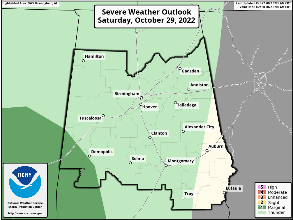
THE CENTRAL ALABAMA WEEKEND: Rain chances will start to increase during the day on Saturday staring in the west and southwestern parts by late morning, and slowly spreading eastward across the western half of the area through the remainder of the day. The SPC continues a low end marginal risk for severe storms (level 1 of 5) for the extreme southwestern parts of the area and down into the western parts of South Alabama for the threat of gusty winds. The rest of Central Alabama may not hear very much thunder at all. Rain chances will continue mainly for the eastern half of the area on Sunday, but a few patches of drizzle can’t be ruled out for the west. Highs in the upper 60s to the mid 70son both days.
NEXT WEEK: A few isolated light showers or patchy drizzle may be possible on Monday, but nearly everyone looks to stay dry at this point. Tuesday looks to be a mostly sunny and dry day. Another impulse looks to move through Central Alabama on Wednesday, bringing a chance of showers to the area. Thursday and Friday look to be dry for now. Highs next week will be mainly in the 70s with overnight lows mostly in the 40s and 50s.
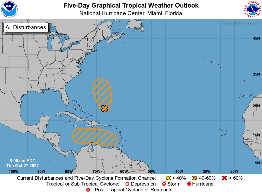
THE TROPICS: Southwestern Atlantic – A trough of low pressure extending from the eastern Caribbean Sea northward to the southwestern Atlantic continues to produce a broad area of disorganized showers and thunderstorms. A surface low pressure system is forecast to emerge along the northern portion of the trough axis later today or tonight, and environmental conditions appear marginally conducive for some subtropical development. A subtropical depression could form during the next couple of days while the system moves northward, then meanders to the west or southwest of Bermuda. Over this weekend, upper-level winds are forecast to become less conducive for development.
* Formation chance through 48 hours…medium…40 percent.
* Formation chance through 5 days…medium…40 percent.
Eastern Caribbean – An area of low pressure is expected to form over the eastern Caribbean Sea this weekend, possibly related to the southern portion of an existing trough of low pressure over the area. Thereafter, environmental conditions are forecast to be conducive for gradual development, and a tropical depression could form early next week while the disturbance moves generally westward or west-northwestward into the central Caribbean Sea.
* Formation chance through 48 hours…low…near 0 percent.
* Formation chance through 5 days…medium…50 percent.
ON THIS DAY IN WEATHER HISTORY – 1843: A snowstorm hit Mississippi, bringing snow, sleet, and freezing temperatures. On the heels of this storm, the area endured a hard freeze the following morning.
Category: Alabama's Weather, ALL POSTS, Severe Weather, Tropical
About the Author (Author Profile)
Scott Martin is an operational meteorologist, professional graphic artist, musician, husband, and father. Not only is Scott a member of the National Weather Association, but he is also the Central Alabama Chapter of the NWA president. Scott is also the co-founder of Racecast Weather, which provides forecasts for many racing series across the USA. He also supplies forecasts for the BassMaster Elite Series events including the BassMaster Classic.Subscribe
If you enjoyed this article, subscribe to receive more just like it.


