Tornado & Severe T-Storm Threat Continues for at Least the Next Few Hours
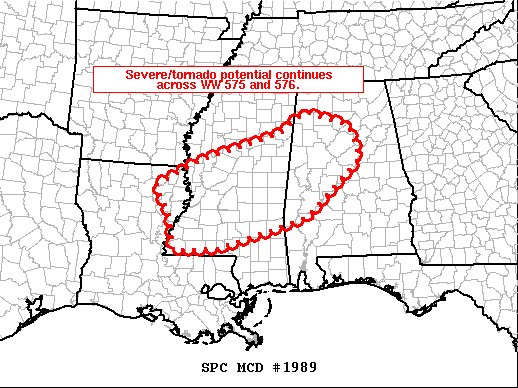
SUMMARY… Severe/tornado risk will continue across portions of Mississippi and Alabama over the next couple of hours.
DISCUSSION… Latest radar loop shows a consolidating, pre-frontal band of strong/locally severe storms extending from northwestern Alabama west-southwestward across northern Mississippi to far northeastern Louisiana. Damaging wind gusts remain the primary severe risk with this band of storms, though a brief tornado is also possible.
Farther to the south/southeast, isolated — and in some cases, rotating — storms continue, from southern and central Mississippi to west-central Alabama. Several of these storms have maintained moderate — but sustained — rotation as they track east-northeastward at around 40 kt. Though rotation has gradually weakened with most storms over the past half hour or so, potential for tornadic spin-ups will persist across this area over the next couple of hours.
Category: Alabama's Weather, ALL POSTS, Severe Weather
About the Author (Author Profile)
Scott Martin is an operational meteorologist, professional graphic artist, musician, husband, and father. Not only is Scott a member of the National Weather Association, but he is also the Central Alabama Chapter of the NWA president. Scott is also the co-founder of Racecast Weather, which provides forecasts for many racing series across the USA. He also supplies forecasts for the BassMaster Elite Series events including the BassMaster Classic.Subscribe
If you enjoyed this article, subscribe to receive more just like it.


