A Few Damage Reports from Gusty Winds; Cold Front Now Invading the State
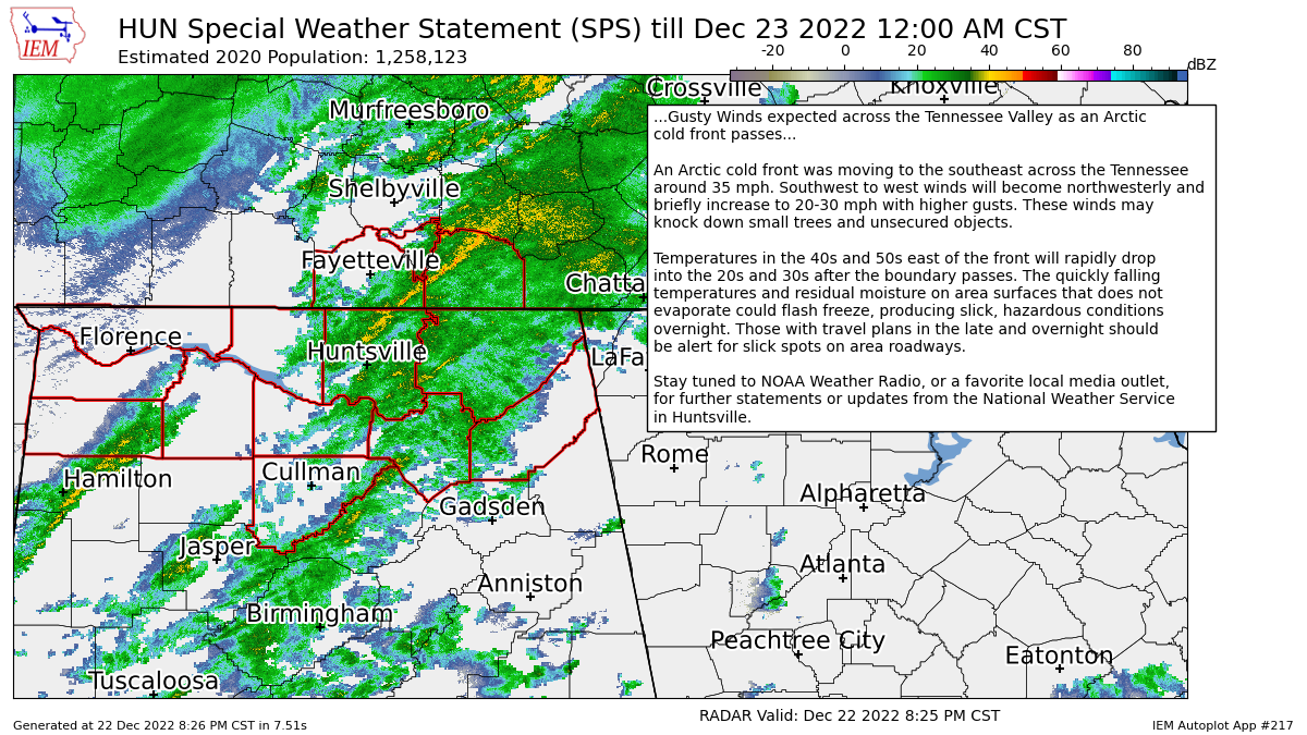
NWS Huntsville has issued a Special Weather Statement on the gusty winds that are occurring across the Tennessee Valley counties, which includes Colbert, Cullman, DeKalb, Franklin, Jackson, Lauderdale, Lawrence, Limestone, Madison, Marshall, and Morgan counties. Here is the text from that statement…
Gusty Winds expected across the Tennessee Valley as an Arctic cold front passes…
An Arctic cold front was moving to the southeast across the Tennessee around 35 mph. Southwest to west winds will become northwesterly and briefly increase to 20-30 mph with higher gusts. These winds may knock down small trees and unsecured objects.
Temperatures in the 40s and 50s east of the front will rapidly drop into the 20s and 30s after the boundary passes. The quickly falling temperatures and residual moisture on area surfaces that does not evaporate could flash freeze, producing slick, hazardous conditions overnight. Those with travel plans in the late and overnight should be alert for slick spots on area roadways.
Here are some damage reports (raw feed from NWS Chat) from up in that area…
Local Storm Report by NWS HUN: 6 SSE Killen [Colbert Co, AL] emergency mngr reports NON-TSTM WND DMG at 08:41 PM CST — tree downed.
Local Storm Report by NWS HUN: 2 W Littleville [Colbert Co, AL] emergency mngr reports NON-TSTM WND DMG at 08:48 PM CST — tree downed.
Local Storm Report by NWS HUN: 1 WNW Tuscumbia [Colbert Co, AL] emergency mngr reports NON-TSTM WND DMG at 08:04 PM CST — tree downed.
Local Storm Report by NWS HUN: 6 W Tuscumbia [Colbert Co, AL] emergency mngr reports NON-TSTM WND DMG at 08:07 PM CST — tree downed.
Local Storm Report by NWS HUN: 1 SE Tuscumbia [Colbert Co, AL] emergency mngr reports NON-TSTM WND DMG at 08:20 PM CST — tree downed.
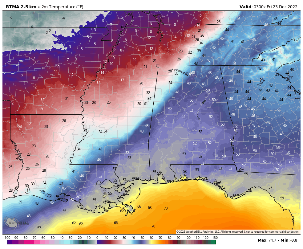
As you can see from the above map, the cold front is now moving through the northwestern quarter of Alabama. These were taken from the 9 pm observations. While it is 48 degrees in Cullman with a few light showers and a flurry or two mixed in, the thermometer has started the quick downward trend as the temperature in Florence was at 28 degrees. Overnight lows are projected to be in the 3º to 25º range from northwest to southeast (Florence to Eufaula).
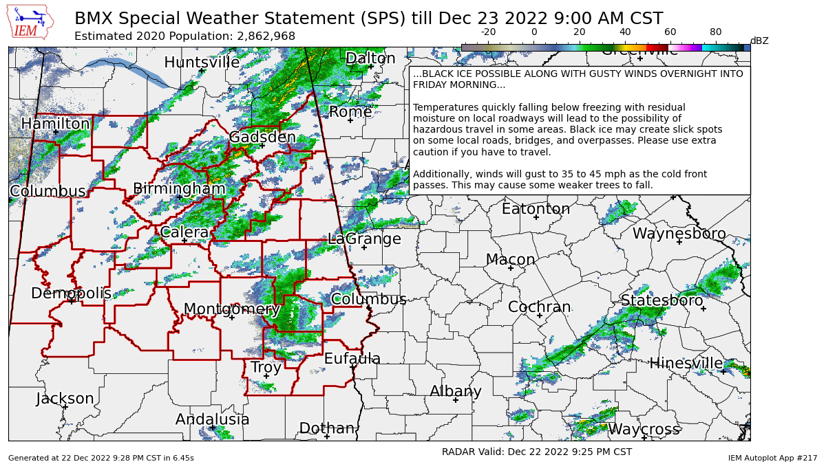
NWS Birmingham just issued a Special Weather Statement on the potential of gusty winds and black ice across Central Alabama. Here is the text from the statement…
BLACK ICE POSSIBLE ALONG WITH GUSTY WINDS OVERNIGHT INTO FRIDAY MORNING…
Temperatures quickly falling below freezing with residual moisture on local roadways will lead to the possibility of hazardous travel in some areas. Black ice may create slick spots on some local roads, bridges, and overpasses. Please use extra caution if you have to travel.
Additionally, winds will gust to 35 to 45 mph as the cold front passes. This may cause some weaker trees to fall.
Seriously… you need to be careful out there on the roadways and highways. I just got back home from a function up in North Alabama, and with the wind picking up and roads already wet from the rainfall with rain still occurring, people were passing us well faster than the speed limit, especially in larger pick-up trucks. This is a time when safety needs to be a priority and not an afterthought. Slow down and arrive alive.
Category: Alabama's Weather, ALL POSTS, Winter Weather
About the Author (Author Profile)
Scott Martin is an operational meteorologist, professional graphic artist, musician, husband, and father. Not only is Scott a member of the National Weather Association, but he is also the Central Alabama Chapter of the NWA president. Scott is also the co-founder of Racecast Weather, which provides forecasts for many racing series across the USA. He also supplies forecasts for the BassMaster Elite Series events including the BassMaster Classic.Subscribe
If you enjoyed this article, subscribe to receive more just like it.


