The Late Afternoon Weather Report — Plenty of Rain on the Way
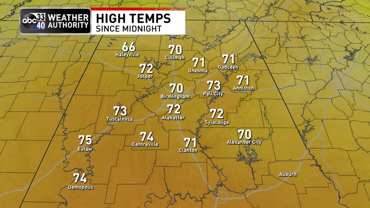
Wow! What a day across much of Central Alabama as mostly clear skies ruled the day with afternoon highs reaching the lower to mid 70s. The west and northwestern parts of the area would have to argue with that a little bit, as clouds and some sprinkles fell, which kept temperatures down in the 60s. The warm spot was Eutaw topping out at 75º, while the cool spot was Haleyville at 66º. Birmingham’s high was 70º.
REST OF TODAY & FRIDAY: We’ll continue to have a very small chance of a few showers over the extreme northwestern parts of the area and up into the western parts of the Tennessee Valley, while the rest of the area will be dry with partly cloudy skies. Lows will only dip down into the mid 40s to the lower 50s.
Friday will start off mainly dry but rain and a few embedded storms will begin to move into the area by midday and move into the Birmingham area right around or just before the evening drive. Rain and storms should reach the Gadsden, Anniston, and Auburn areas by the 6-7 pm time frame. Instability will be very limited and nearly all the activity will be elevated, but I can’t rule out a strong storm over the southern half of the area. Highs will be in the lower 60s to the lower 70s.
NEW YEAR’S WEEKEND: Saturday’s activity is now trending as scattered showers and some thunder with nearly all the activity out of the area and over into Georgia by the late local news. After that, while a few stray light showers or sprinkles may move across the area, Central Alabama is trending dry at this point, especially at midnight. Highs in the lower 60s to the mid 70s, with midnight temperatures in the 50s. New Year’s Day continue to trend dry and mild with mostly sunny skies, as highs will be up in the mid 60s to the lower 70s.
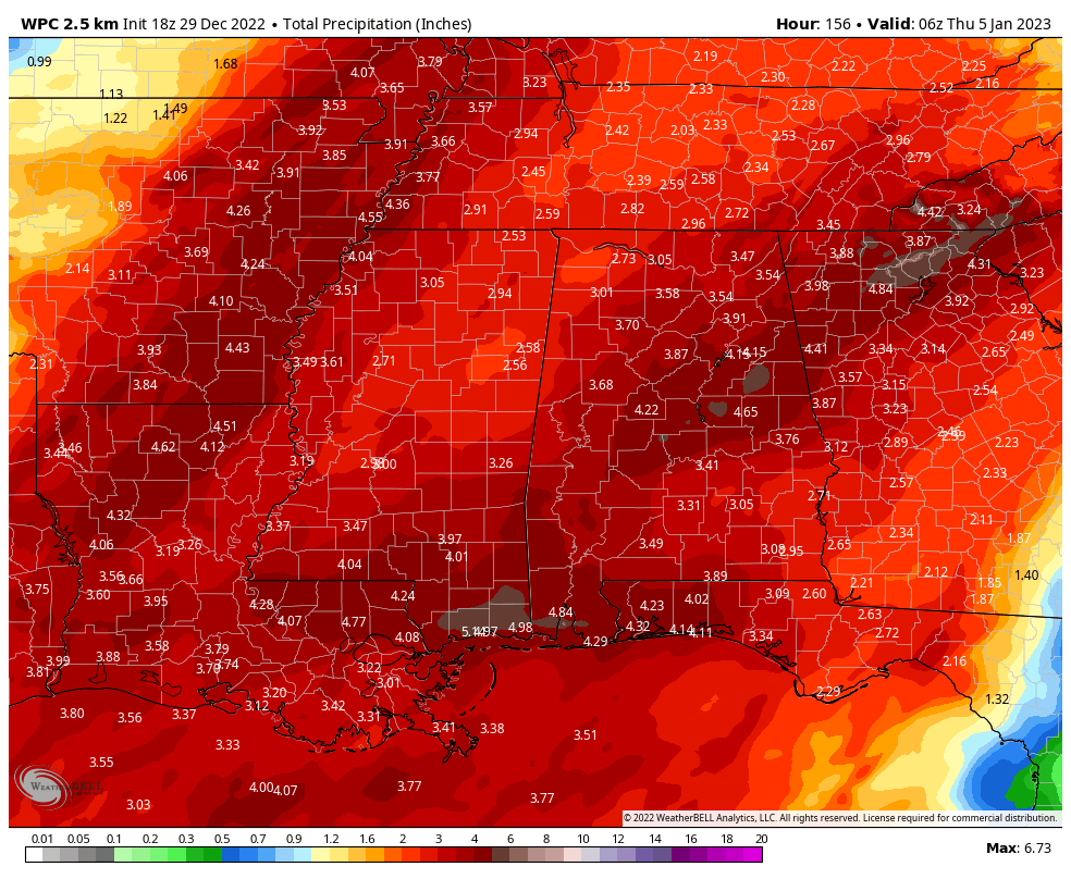
NEXT WEEK: The first three days of the work week look to be wet and stormy at times with plenty of rainfall, some will be heavy at times potentially leading to some flooding issues. The good news is that numbers have come down from the previous runs, but forecast amounts look to be 2.50 in to 5.00 in across the area through Wednesday at midnight. That is still plenty of water to cause some issues.
Rain chances will start to move into the western parts of the area during the mid-morning hours on Monday and will eventually spread eastward through the rest of the day. There will be a lull in-between that activity, and the main event that will start to move in by sunrise on Tuesday morning. Rain chances will start to dwindle downward on Wednesday evening, but we’ll keep a chance of showers in the forecast through the morning hours on Thursday.
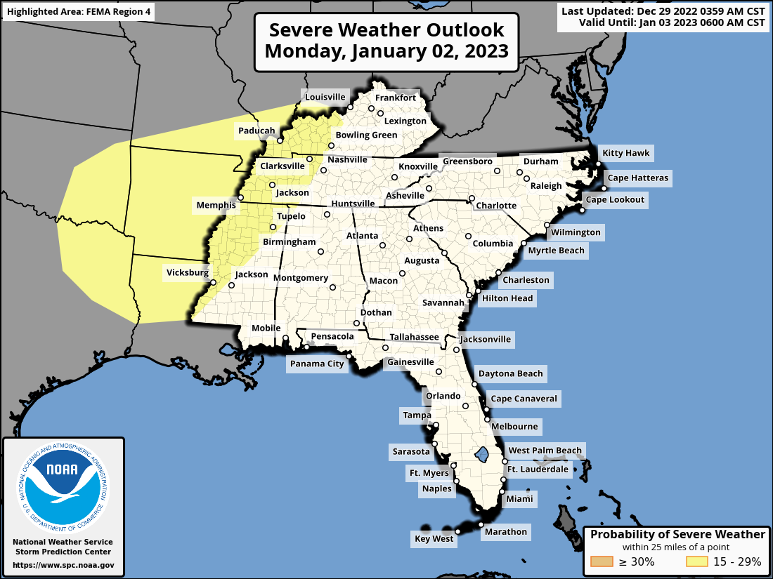
For now, there is no threat of severe storms at anytime for Central Alabama through this multi-day event. However, there is the equivalent of a Slight Risk up on Monday for much of the mid-south and down into the western parts of the southeast, which does clip the extreme western parts of the Tennessee Valley Region of Alabama. Our main concern here will be on Tuesday and Wednesday with the threat of some flooding issues.
Once the rain exits, cooler air will start to move back into the area. With clearing skies on Thursday afternoon, highs will be in the upper 40s to the lower 60s. Friday will be in the 60s with plenty of sunshine.
Category: Alabama's Weather, ALL POSTS, Severe Weather
About the Author (Author Profile)
Scott Martin is an operational meteorologist, professional graphic artist, musician, husband, and father. Not only is Scott a member of the National Weather Association, but he is also the Central Alabama Chapter of the NWA president. Scott is also the co-founder of Racecast Weather, which provides forecasts for many racing series across the USA. He also supplies forecasts for the BassMaster Elite Series events including the BassMaster Classic.Subscribe
If you enjoyed this article, subscribe to receive more just like it.


