Mesoscale Discussion — Tornado Threat Locally Maximized Over Parts of Central Alabama & Southeastern Mississippi
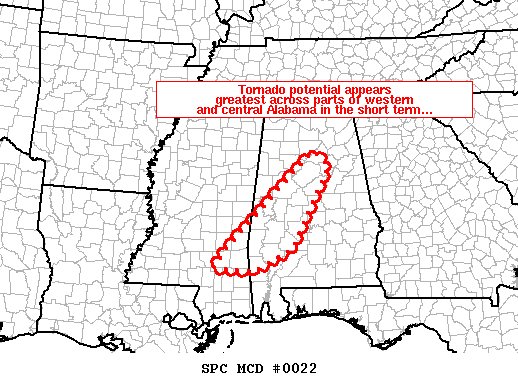
SUMMARY… Tornado potential appears to be locally maximized at this time in a corridor from southeastern Mississippi into central Alabama.
DISCUSSION… Latest radar loop shows a fairly organized band of strong/locally severe storms crossing the Tennessee Valley area at this time — within northern portions of Tornado Watch 007. However, at least transiently rotating updrafts have remained focused mainly within a zone from parts of southeastern Mississippi northeastward into adjacent western Alabama.
In particular, radar currently shows several small, rotating updrafts moving across the Hale and Marengo County vicinity in western Alabama — within eastern portions of the WW. As these storms shift northeastward with time, along the eastern fringes of the watch, a local extension of a few counties will contain this potential in the short term.
Otherwise, risk for locally damaging winds, and a couple of tornadoes, continues across the broader WW area.
Category: Alabama's Weather, ALL POSTS, Severe Weather
About the Author (Author Profile)
Scott Martin is an operational meteorologist, professional graphic artist, musician, husband, and father. Not only is Scott a member of the National Weather Association, but he is also the Central Alabama Chapter of the NWA president. Scott is also the co-founder of Racecast Weather, which provides forecasts for many racing series across the USA. He also supplies forecasts for the BassMaster Elite Series events including the BassMaster Classic.Subscribe
If you enjoyed this article, subscribe to receive more just like it.


