New Tornado Watch Issued Until 8 pm for the Eastern Parts of the Area
NWS Birmingham and the Storm Prediction Center has issued a new TORNADO WATCH effective until 8 pm this evening for the following counties in Central Alabama: Calhoun, Chambers, Cherokee, Clay, Cleburne, Coosa, Elmore, Etowah, Lee, Macon, Montgomery, Randolph, St. Clair, Talladega, and Tallapoosa.
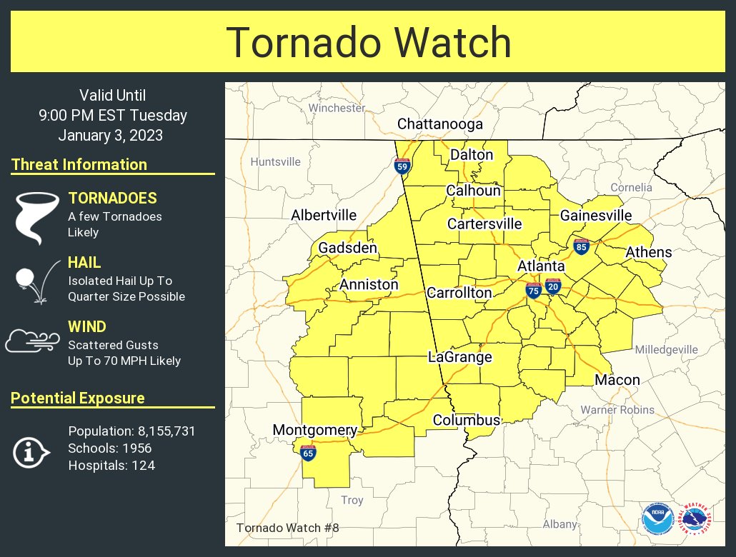
The NWS Storm Prediction Center has issued a
* Tornado Watch for portions of
Eastern Alabama
Northern and Central Georgia
* Effective this Tuesday afternoon and evening from 155 PM until
900 PM EST.
* Primary threats include…
A few tornadoes likely
Scattered damaging wind gusts to 70 mph likely
Isolated large hail events to 1 inch in diameter possible
SUMMARY…Clusters of thunderstorms over central Alabama will track
eastward across the watch area this afternoon and early evening.
Sufficient instability and winds aloft will pose a risk of damaging
wind gusts and a few tornadoes.
PRECAUTIONARY/PREPAREDNESS ACTIONS…
REMEMBER…A Tornado Watch means conditions are favorable for
tornadoes and severe thunderstorms in and close to the watch
area. Persons in these areas should be on the lookout for
threatening weather conditions and listen for later statements
and possible warnings.
Category: Alabama's Weather, ALL POSTS, Severe Weather
About the Author (Author Profile)
Scott Martin is an operational meteorologist, professional graphic artist, musician, husband, and father. Not only is Scott a member of the National Weather Association, but he is also the Central Alabama Chapter of the NWA president. Scott is also the co-founder of Racecast Weather, which provides forecasts for many racing series across the USA. He also supplies forecasts for the BassMaster Elite Series events including the BassMaster Classic.Subscribe
If you enjoyed this article, subscribe to receive more just like it.


