Mesoscale Discussion — New Watch Possible Within the Next Few Hours
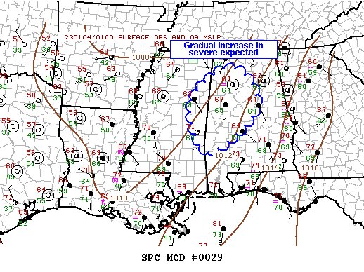
SUMMARY… A gradual increase in convection is expected as the evening progresses, with it a risk of wind and perhaps a tornado or two. A new watch may be warranted.
DISCUSSION… Boundary-layer air mass is expected to gradually respond across the lower MS Valley due to an approaching short-wave trough over Texas. Low-level flow should become a bit more convergent which should encourage additional convective development and perhaps more robust updrafts. Over the last hour or so, a fair number of thunderstorms have matured from south-central LA into east-central MS. Several supercells are observed along this corridor and an upward tick in coverage/intensity may be noted as the evening progresses. Overall, scattered strong/severe thunderstorms should become more noteworthy prior to frontal passage. A new watch may be warranted to account for this risk.
Probability of Watch Issuance…60 percent
Category: Alabama's Weather, ALL POSTS, Severe Weather
About the Author (Author Profile)
Scott Martin is an operational meteorologist, professional graphic artist, musician, husband, and father. Not only is Scott a member of the National Weather Association, but he is also the Central Alabama Chapter of the NWA president. Scott is also the co-founder of Racecast Weather, which provides forecasts for many racing series across the USA. He also supplies forecasts for the BassMaster Elite Series events including the BassMaster Classic.Subscribe
If you enjoyed this article, subscribe to receive more just like it.


