Mesoscale Discussion — Severe Threat Continues Across Current Tornado Watch Locations
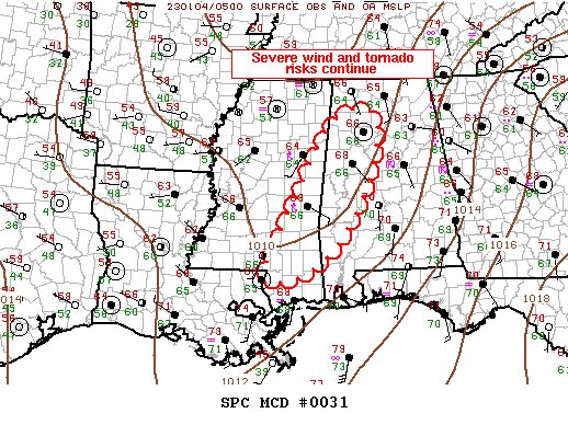
SUMMARY… Severe wind/tornado risk will spread east across Mississippi into Alabama over the next several hours.
DISCUSSION… A pre-frontal band of broken convection is gradually expanding in areal coverage late this evening. Numerous robust/severe thunderstorms extend along a corridor from southeast LA, through east-central MS, into northwest AL. Within this corridor, several long-lived supercells continue with one potentially tornadic storm over Clarke County MS, moving toward Choctaw County AL. This activity is maturing within a strongly sheared environment coincident with a 35kt LLJ. Instability has gradually recovered ahead of this convection with roughly 2000 J/kg MUCAPE now evident across the southern half of ww011. Damaging winds, along with some tornado risk, continue.
Category: Alabama's Weather, ALL POSTS, Severe Weather
About the Author (Author Profile)
Scott Martin is an operational meteorologist, professional graphic artist, musician, husband, and father. Not only is Scott a member of the National Weather Association, but he is also the Central Alabama Chapter of the NWA president. Scott is also the co-founder of Racecast Weather, which provides forecasts for many racing series across the USA. He also supplies forecasts for the BassMaster Elite Series events including the BassMaster Classic.Subscribe
If you enjoyed this article, subscribe to receive more just like it.


