954 am: Mesoscale Update from the SPC
Instability is present in sufficient amounts and the wind shear is more than ample for the storms across West Central Alabama. The storm just northeast of Eutaw shows very strong rotation and could produce a tornado at any time. I would expect this and other storms coming out of eastern Missisispi to be capable of producing tornadoes for the next couple of hours at least.
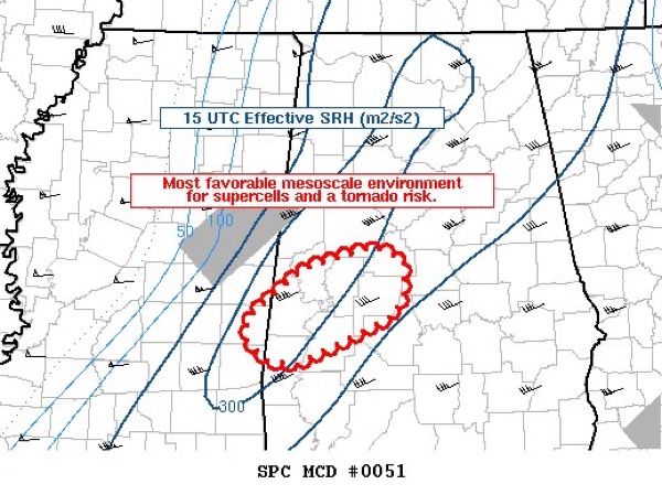
Mesoscale Discussion 0051
NWS Storm Prediction Center Norman OK
0954 AM CST Thu Jan 12 2023
Areas affected…west-central AL…far east-central MS
Concerning…Tornado Watch 17…
Valid 121554Z – 121730Z
The severe weather threat for Tornado Watch 17 continues.
SUMMARY…Most favorable mesoscale environment for supercells and a
tornado risk is focused near the MS/AL border and into west-central
AL through 1130am CST.
DISCUSSION…Subjective mesoscale analysis shows temperatures
warming into the lower 70s over west-central AL to the east of a
broken band of storms with several quasi-discrete updrafts. Surface
dewpoints are in the lower 60s and RAP forecast soundings indicate
around 1000 J/kg MLCAPE when modifying for current surface
observations. Long hodographs will continue to promote a
supercellular storm mode. In addition, around 200-250 m2/s2 0-0.5
km effective SRH is indicated. Given this overlap of
buoyancy/shear, it appears the most favorable mesoscale environment
will be focused over west-central AL over the next 1-2 hours. A
tornado risk will continue with any robust supercell.
..Smith.. 01/12/2023
Category: ALL POSTS
About the Author (Author Profile)
Bill Murray is the President of The Weather Factory. He is the site's official weather historian and a weekend forecaster. He also anchors the site's severe weather coverage. Bill Murray is the proud holder of National Weather Association Digital Seal #0001 @wxhistorianSubscribe
If you enjoyed this article, subscribe to receive more just like it.


