The Mid-Afternoon Report: Bright, Sunny, but Still Rather Chilly
THIS WEEKEND: As of 2:34 pm, all you see in the skies across Central Alabama is the color of cobalt blue… one of my favorite colors in the spectrum. While it is bright and sunny, a little breeze with these cooler temperatures definitely makes it feel like winter. Temperatures as of the 2 pm roundup were in the lower 40s to the lower 50s across the area. Troy was the warm spot at 51 degrees, while Gadsden was the cool spot at 41 degrees. Birmingham was at 44 degrees.
Skies will remain mainly clear across the area as we go into the evening and late-night hours, but we may have some thin clouds move in from the northwest. It will be a chilly night as lows will get down into the mid to upper 20s across the area. Those thin clouds will filter out a little bit of sunshine at times on Sunday, but it will still be a bright but warmer day across Central Alabama as highs will reach the mid to upper 50s for most.
NEXT WEEK: Moisture will begin to build out ahead of a low moving through the upper Midwest on Monday, that will bring an increase of clouds and the potential for a few showers during the evening and overnight hours. Highs in the upper 50s to the upper 60s.
More showers will move through Central Alabama on Tuesday, especially during the pre-dawn and morning hours, with much of the activity diminishing through the rest of the day. Highs in the mid 60s to the mid 70s.
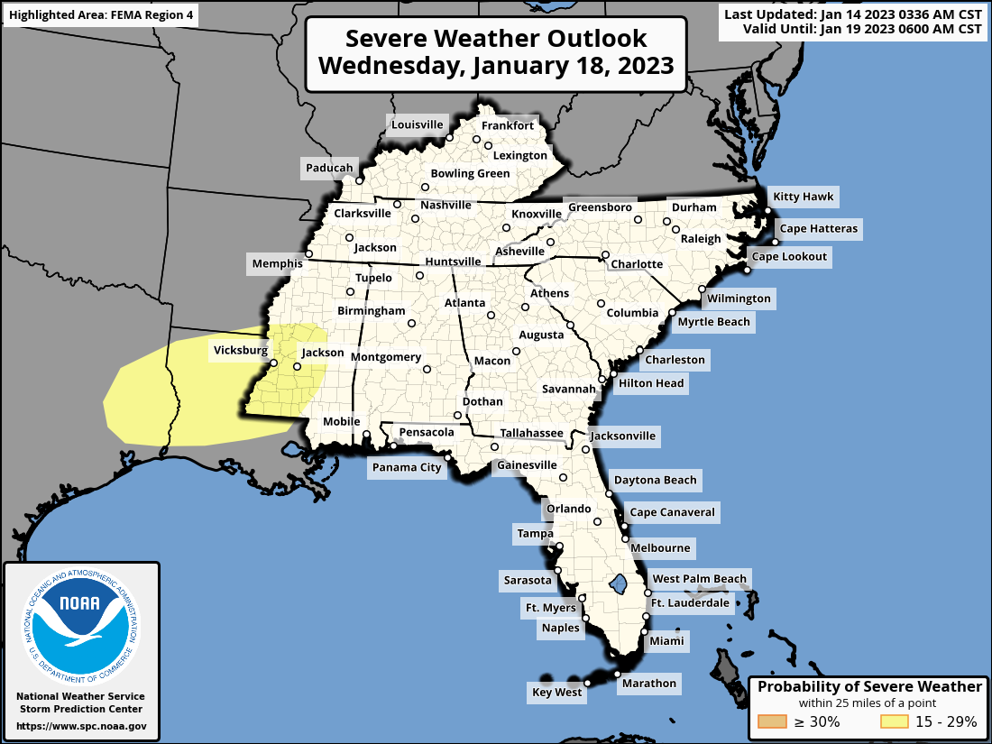
Another wave of rain and thunder will form off to our west very early on Wednesday and begin to move into the area after midday. Rain and storms will be likely through the rest of the day, and we will have to watch for a few strong storms. As shown above, the SPC has a Slight Risk outlined for the southwestern quarter of Mississippi, much of the northern 2/3rds of Louisiana, and back into far eastern Texas throughout the day. Highs will be in the upper 60s to the mid 70s.
A cold front will move into the area by Thursday morning and will progress across Central Alabama and exiting the area by the evening hours. Once again, we may have to watch for a few strong storms, especially over the southern half of the area. Highs in the mid 60s to the lower 70s.
And at the end of the forecast period on Friday… Skies will begin to slowly get brighter as clouds will be moving out of the area. We’ll have partly to mostly sunny skies with highs in the upper 50s to the upper 60s.
Category: Alabama's Weather, ALL POSTS, Severe Weather
About the Author (Author Profile)
Scott Martin is an operational meteorologist, professional graphic artist, musician, husband, and father. Not only is Scott a member of the National Weather Association, but he is also the Central Alabama Chapter of the NWA president. Scott is also the co-founder of Racecast Weather, which provides forecasts for many racing series across the USA. He also supplies forecasts for the BassMaster Elite Series events including the BassMaster Classic.Subscribe
If you enjoyed this article, subscribe to receive more just like it.


