Sunday Weather Video: Rains the Main Story the Next Two Weeks
Saturday was a beautiful but chilly day across Alabama. Highs were mostly in the 40s, including 44F at Anniston, 46F at Birmingham, and 47F at Calera. It was 50F at Tuscaloosa.
WET WEATHER AHEAD: The next two weeks look like they will be wet ones across much of Alabama. With that wetness will come warmth as well. Two-week rainfall totals could approach 6 or more inches in spots. Let’s kind of dig in and see how that might play out.
OR YOUR SUNDAY: High pressure will be ridging into Alabama today, giving us another nice day of mostly sunny skies. A few high clouds will work in during the day.. Winds will gradually become more southerly and temperatures will warm into the 50s. Lows tonight will be in the 30s.
MOISTURE BUILDS FOR THE HOLIDAY MONDAY: Moisture levels will be rising and clouds will be increasing tomorrow. A southerly wind will be increasing as well, gusting at times to 25-30 mph at times. Highs will warm into the upper 50s and lower 60s. A few showers will begin to encroach on the area late, especially over Northwest Alabama. Rain chances will increase overnight, and most of the rain will move out during the morning hours on Tuesday. Rainfall amounts from this first system will be less than one-quarter of an inch generally.
MIDWEEK PERIOD: Skies will become partly sunny during the day on Tuesday and temperatures will warm into the upper 60s and lower 70s since the airmass will not change when the rain moves out. There could be a few showers during the afternoon, and I wouldn’t be surprised to hear a little thunder, as a meager amount of instability may be available. Another wave of low pressure will swing across on Wednesday, bringing increasing rain chances and a definite chance of thunderstorms. They shouldn’t be severe though. Highs on Wednesday will be in the upper 60s to lower 70s after morning lows in the 50s. A cold front will be moving through on Thursday, giving us more showers and storms. Some of the storms will be strong, mainly over South Alabama.
HEADING TO THE WEEKEND: Clouds will be decreasing behind the front on Friday and temperatures will be a tad cooler with highs in the middle 50s to lower 60s. But rain will return quickly on Saturday as yet another wet weather system heads our way. Rain chances will increase late in the day and become steady overnight, lasting into Sunday. It could end up being a good soaking for much of the area, with rainfall amounts pushing 2-4 inches across the area.
ALL OF THAT ADDS UP: If these systems materialize as the GFS is forecasting, some parts of Alabama could be pushing up over 6 inches of rain, and some approaching 10 inches. That is pretty serious rainfall and something that will start to lead to flooding pretty quickly.
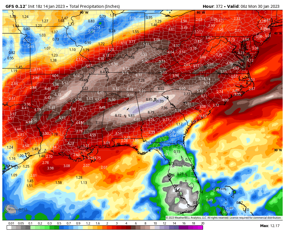
16 day rainfall totals off the deterministic GFS
TALKING ABOUT ADDING UP: The snowpack over the Sierra Mountains of California is starting to really add up. The snowpack right now across the northern Sierra is already at 199% of normal for the date, the Central Sierra at 229% of normal, and the southern Sierra at 263% or normal! And it has been snowing to beat the band all through the Sierra since late last night. Snowfall rates reached 4 inches per hour and I-80 was completely shut down across Donner Pass. Large avalanches are potentially a problem in the Lake Tahoe area as well. Another round of heavy snow will move in tonight and continue for much of Monday.
BEACHCAST: The brief cool snap along the beautiful beaches of Alabama and Northwest Florida will leave starting today, with highs near 60F this afternoon and 70s returning until week’s end. Showers will be absent until late Monday, but they will be a prominent part of the forecast through the end of the week and even over the weekend as waves of low pressure bring precipitation. But at least the mild readings will pretty much continue with 70s on Saturday and upper 60s on Sunday. Water temperatures are in the upper 50s. The rip current risk will be high starting Monday night.
Click here to see the Beach Forecast Center page.
NATIONALLY: Survey crews from the NWS in Birmingham are still working to tabulate all of the tornadoes from Thursday across their area of responsibility. As of Friday, they had already written reports on seven tornadoes, and they had not even reported on Autauga and Elmore Counties yet. Of the 7, four were EF2, including the Selma Tornado. They warn that some of the storms could still be upgraded. The Selma Tornado was on the ground for 23.6 miles. The NWS in Mobile reports 3 tornadoes, including one EF2 and the morning tornado up in Huntsville’s County Warning Area was a high end EF1.
DANCING WITH THE STATS: 62F at Rapid City SD yesterday tied their record for the date.
ADVERTISE WITH US: Deliver your message to a highly engaged audience by advertising on the AlabamaWX.com website. We have a lot of big plans for this year. Don’t miss out! We can customize a creative, flexible, and affordable package that will suit your organization’s needs. Contact me, Bill Murray, at (205) 687-0782, and let’s talk.
WEATHERBRAINS: This week, the panel will entertain a group of meteorologists who are graduates of Penn State University’s program. What you wanna bet the phrase, “We are…Penn State” will be exclaimed a few times? Check out the show at www.WeatherBrains.com. You can also subscribe on iTunes. You can watch the show live on the show’s new YouTube channel, www.YouTube.com/weatherbrains. You will be able to see the show on the James Spann 24×7 weather channel on cable or directly over the air on the dot 2 feed.
ON THIS DATE IN 1958: There have been four hurricane reconnaissance planes lost since the practice was started in the mid-1940s. Three have been lost in the Pacific, one in the Atlantic. A WB-50 from the 54th Weather Reconnaissance Squadron on Guam was lost during Supertyphoon Orphelia southwest of Guam. Follow my weather history tweets on Twitter. I am @wxhistorian at Twitter.com.
Category: Alabama's Weather, ALL POSTS, Severe Weather
About the Author (Author Profile)
Bill Murray is the President of The Weather Factory. He is the site's official weather historian and a weekend forecaster. He also anchors the site's severe weather coverage. Bill Murray is the proud holder of National Weather Association Digital Seal #0001 @wxhistorianSubscribe
If you enjoyed this article, subscribe to receive more just like it.


