

Midday Nowcast: Increasing Clouds with a Warming Trend
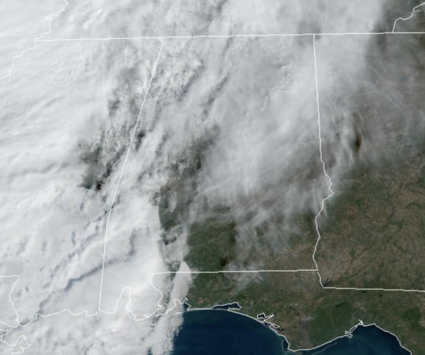
Southerly flow is increasing across Alabama today and that is allowing for more clouds and the start of a warming trend. Temperatures this afternoon are in the 60s across much of Alabama, while some 70s are showing up across South Alabama. Despite the clouds, most of us stay dry today, with the exception of a few stray showers across Northwest Alabama. Showers will increase in average overnight and into tomorrow statewide, but nothing especially heavy and really more of a nuisance. Tomorrow will be mostly cloudy with highs closer to 70°.
STORMS RETURN: Some scattered showers are possible Wednesday, but most of the day should be dry and mild with afternoon temperatures reaching the low 70s. Late Wednesday night and into Thursday, a cold front will push a band of rain and thunderstorms into the state. For now, the SPC has defined a “marginal risk” (level 1/5) of severe storms for the northwest corner of the state Wednesday night. At this time, no part of Alabama is highlighted in a risk for Thursday, but that could change in the coming days.
The main dynamics with this system will be north of Alabama, while marginal thermodynamics should limit the overall severe potential for Alabama, but should instability values rise higher than forecast now, some risk of severe storms might have to be introduced across Alabama on Thursday. We will mention that some stronger storms are possible along with heavier rainfall are expected early Thursday morning as the front swings through the state. Rain amounts of around one inch are expected. The rain and storms will be over with by Thursday afternoon.
FRIDAY AND THE WEEKEND: Friday will be a mostly sunny, cooler day with a high in the 50s over North Alabama, with 60s to the south. Then, the next weather system will bring more rain into Alabama over the weekend. Periods of rain are likely Saturday and Sunday with highs in the 50s. Some thunder is possible, but there is no risk of severe storms.
BEACH FORECAST CENTER: Get the latest weather and rip current forecasts for the beaches from Fort Morgan to Panama City on our Beach Forecast Center page. There, you can select the forecast of the region that you are interested in visiting.
WORLD TEMPERATURE EXTREMES: Over the last 24 hours, the highest observation outside the U.S. was 117.1F at Augrabies Falls, South Africa. The lowest observation was -80.1F at Tongulah, Russia.
CONTIGUOUS TEMPERATURE EXTREMES: Over the last 24 hours, the highest observation was 84F at Falcon Lake, TX. The lowest observation was -6F at Saranac Lake, NY.
Category: Alabama's Weather, ALL POSTS
About the Author (Author Profile)
Macon, Georgia Television Chief Meteorologist, Birmingham native, and long time Contributor on AlabamaWX. Stormchaser. I did not choose Weather, it chose Me. College Football Fanatic. @Ryan_StinnetSubscribe
If you enjoyed this article, subscribe to receive more just like it.


