Sunday Morning AlabamaWX Weather Briefing: Record Warmth Ahead
It was on this date in 1884 that the Enigma Tornado Outbreak struck the southern United States from Mississippi to Virginia with at least 60 tornadoes, and almost certainly many more. Estimates of the death toll range from 182 to over 1,200, hence the name of the outbreak. The death toll is an enigma. The town of Leeds east of Birmingham was hit hard. A tornado struck the schoolhouse at Goshen, Alabama near Piedmont, blowing it “to atoms.” The schoolmaster was killed and 25 students were injured. More in a special post on the blog later this morning.
THIS WEEK’S WEATHER CERTAINLY ISN’T AN ENIGMA…Things will definitely be warming up. We are starting off in the 30s this morning, with only the normally colder spots near or below freezing. Clouds thickened quickly overnight as a fast-moving disturbance moved through the Great Lakes. We should see increasing sunshine during the day today, with everyone eventually at least partly sunny, and most partly cloudy to mostly sunny. Afternoon readings will range from around 59F over the Tennessee Valley to 62F in the I-20 Corridor to 66F down around Montgomery. Lows tonight will be in the 40s areawide.
NEW WORK WEEK: A big trough will be trying to form across the Great Lakes, and Ohio Valley by Monday. A brisk southwesterly flow aloft will thicken our clouds again but we will remain dry. Temperatures Monday afternoon will range from the 60s Northeast to lower and middle 70s the further south you journey.
RECORD BREAKING WEEK: Record highs will start to fall by Tuesday across the South. Monroe LA is forecast to hit 81F and Tallahassee to hit 83F. Both would be records. By Wednesday, two dozen records could fall from the Arklatex to the Carolinas. Thursday, records will be falling in bunches, all the way up into the Ohio Valley, back to the Texas Coast, and over all of Florida. Here in Alabama, highs Tuesday, Wednesday, and Thursday will climb from the lower and middle 70s into the lower 80s. It will be downright hot by Thursday, with forecasted highs in the 80-degree range up North with middle 80s across Central Alabama. Birmingham’s record high on Thursday is 83F. That will be in jeopardy. So will Wednesday’s 81F.
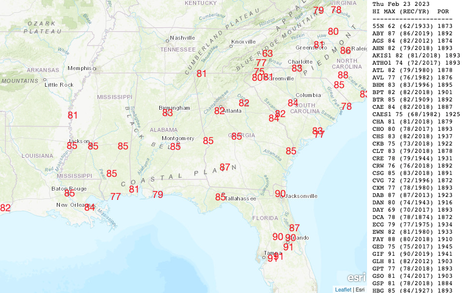
Forecasted potential record highs for Wednesday
RAIN CHANCES: Tuesday, the big trough up north will try to sink a front into the Southeast. There could be a few storms on Tuesday with a propensity to produce hail. Chances look pretty small though. By Wednesday, surface low pressure will be swinging across Missouri. Showers and thunderstorms will intensify during the afternoon over the Arklamiss. Some of them could get into Northwest Alabama Wednesday night. The SPC does have areas to the west of our state outlook for a severe weather threat on Wednesday. It looks like the activity will peter out during the day over Alabama as its upper-level support runs off and leaves it. A stronger surface low sliding through the Midwest will bring gusty winds to Alabama late Thursday and Friday.
THE ALABAMA WEEKEND: High pressure will hold through Sunday morning before breaking down enough to allow showers and thunderstorms to return to the Alabama weather scene. Weekend highs will be in the 60s and 70s Friday, 70s, and 80s Saturday, and back into the 60s, 70s, and 80s as the rain and storms move back in. It looks like southern Alabama and Mississippi could have strong storms Sunday.
VOODOO TERRITORY: The Week Two period looks dry until late Thursday and Friday. The pattern for Friday the 3rd looks like it could produce severe weather. We will be watching carefully.
BEACHCAST: Dry for the foreseeable future along the beautiful beaches of Alabama and Northwest Florida. Rain may not return until Sunday night a week from now. There could be a few light showers late in the week. Highs in the 60s today, but 70s the rest of the week. A breezy south wind will kick in by Friday, so rip currents will be a problem through next weekend. But with water temperatures in the upper 50s, it is too cool to be in the ocean anyway, right?
Click here to see the Beach Forecast Center page.
NATIONALLY: Not much going on across the country this weekend. Snow and wind have prompted winter storm watches, winter weather advisories, and wind alerts across the northern Rockies. More snow will break out in the week ahead starting in the West, with heavy amounts of snow across a wide area. The heavy snow will break out across the Northern Plains and Upper Midwest by Tuesday, and by midweek, they will be measuring the white stuff with yardstick from southern Minnesota across Wisconsin into northern Michigan.
DANCING WITH THE STATS: 3 tornadoes were reported on Thursday in northern Mississippi and southern Tennessee according to the NWS Memphis. The strongest was an EF2 tornado in Tippah County, MS that injured one person along its 11.1-mile path. It was top winds of 125 mph. The Smithville Tornado was a brief EF-0 that had winds of 80 mph along a 1.11-mile path in Monroe County. The other tornado was an EF1 in McNairy County, Tennessee. It reportedly had winds of 105 mph along its 3.17-mile path.
ADVERTISE WITH US: Deliver your message to a highly engaged audience by advertising on the AlabamaWX.com website. We have a lot of big plans for this year. Don’t miss out! We can customize a creative, flexible, and affordable package that will suit your organization’s needs. Contact me, Bill Murray, at (205) 687-0782, and let’s talk.
WEATHERBRAINS: This week, the panel will entertain Dr. Kristine Harper, author of the outstanding book Weather by the Numbers about the history of numerical weather prediction. Check out the show at www.WeatherBrains.com. You can also subscribe on iTunes. You can watch the show live on our new YouTube channel for the show.You will be able to see the show on the James Spann 24×7 weather channel on cable or directly over the air on the dot 2 feed.
ON THIS DATE IN 1871: Professor Cleveland Abbe of the Signal Service issued the first weather synopsis and forecasts along with the warnings to Mariners for the Great Lakes. Follow my weather history tweets on Twitter. I am @wxhistorian at Twitter.com.
Category: Alabama's Weather, ALL POSTS, Severe Weather
About the Author (Author Profile)
Bill Murray is the President of The Weather Factory. He is the site's official weather historian and a weekend forecaster. He also anchors the site's severe weather coverage. Bill Murray is the proud holder of National Weather Association Digital Seal #0001 @wxhistorianSubscribe
If you enjoyed this article, subscribe to receive more just like it.


