Sunday Noon Forecast Update: Records Are Gonna Fall This Week
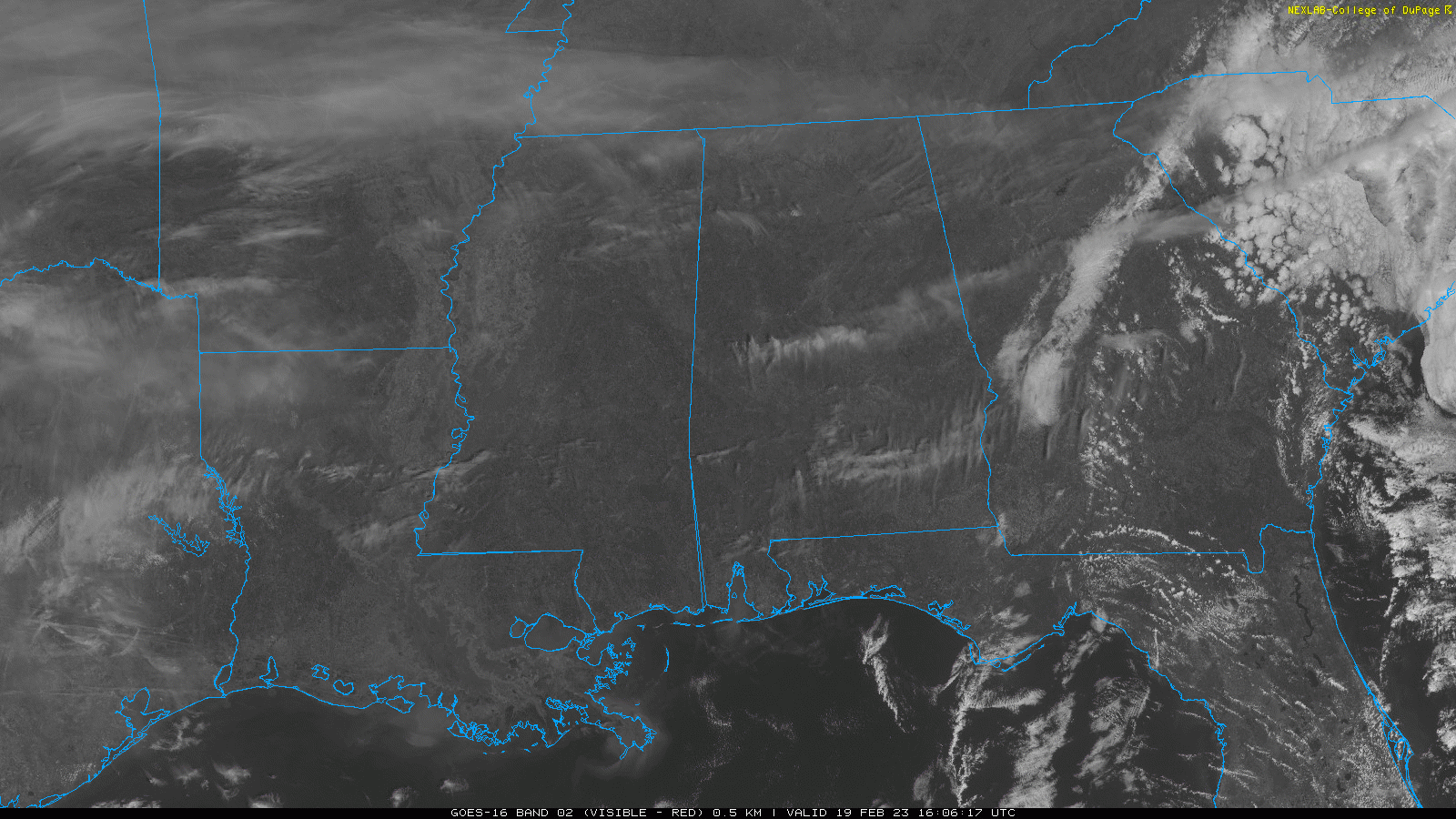
Clouds thinned through the morning hours across Alabama as expected. Beautiful visible satellite imagery shows show thin gauzy cirrus across the Tennessee Valley with some higher, more pronounced cirrus racing across South Alabama in a fast split jetstream flow.
That southern branch is scooping up lots of Pacific moisture and shunting it cross-country like a hot express double-stack container train, but the main result will be clouds for the Southland. They should thicken after a pretty sunset tonight, and the blanket will keep us in the 40s for nighttime lows.
Monday and Tuesday both look to be mostly cloudy, but that won’t hold back the warmth. We find ourselves on the northern side of strong high pressure over the Gulf of Mexico, and that high is going to consolidate its power over the South Atlantic States early in the week. The battle between this high and the big trough to the north will feature a few showers that will drift into North Alabama Monday night and early Tuesday, but they will turn tail north during the day on Tuesday as the high flexes its muscle. Tuesday highs will be in the 70s areawide, with a rogue 80F from somewhere around the State Capital.
The big upper low off the California coast will shoot out to the northeast in the flow as an upper-level disturbance and it will be sufficient to spin up a surface low over Kansas by early Wednesday. There will be enough CAPE in advance of the system to flare up showers and thunderstorms by Wednesday over Oklahoma and Texas. Those will move into Arkansas and Louisiana Wednesday afternoon, where they could be severe. But they are expected to weaken as they move into Mississippi late Wednesday afternoon and wont be severe here.
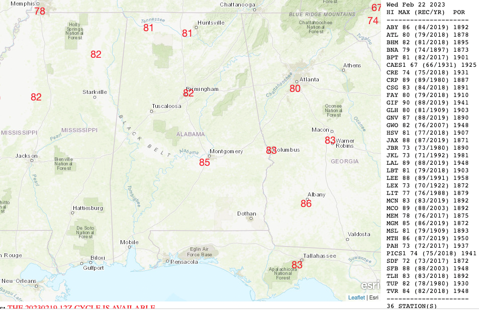
Wednesday highs will be scorching for February, ranging from 78-80F across the Valley, to 81-83F in the I-20 Corridor, to 82-85F in the US-80 Corridor. Here are potential records for Wednesday:
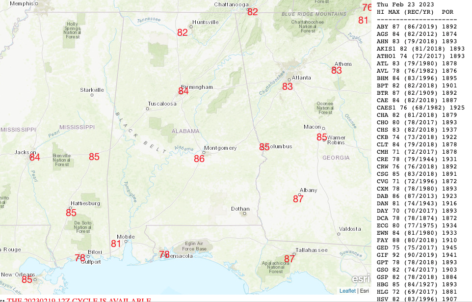
There will be a few showers and a little thunder across Northwest and North Central Alabama Wednesday night into early Thursday as the front settles into the northern half of the state. The rest of the day Thursday looks dry. It will get even hotter, with highs in the vicinity of 81F up North, and between 83-87F across Central sections. Here sare potential records for Thursday:
There could be a few showers Friday and Saturday along the lingering boundary, mainly over North Alabama. It will be slightly cooler Friday with highs in the upper 60s North to low to mid 70s Central. Montgomery still tries to hit 81F.
But Saturday will bounce back in the temperature department. Expect mid and upper 70s North and low to mid-80s Central.
Temperatures will trend back into more reasonable zones starting over the weekend. Rain and storms arrive again on Monday. Highs in week two will drop back into the 60s and 70s, still a little above average, but not the record-setting territory of this week.
Category: Alabama's Weather, ALL POSTS
About the Author (Author Profile)
Bill Murray is the President of The Weather Factory. He is the site's official weather historian and a weekend forecaster. He also anchors the site's severe weather coverage. Bill Murray is the proud holder of National Weather Association Digital Seal #0001 @wxhistorianSubscribe
If you enjoyed this article, subscribe to receive more just like it.


