Parts of Central Alabama Upgraded to a Moderate Risk
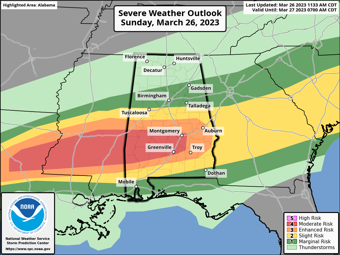
• A Moderate Risk has been issued for locations along and south of a line from Demopolis to just north of Montgomery and down to Olustee (northwest corner of Pike Co.).
• The Enhanced Risk has been edited a little and is south of a line from Geiger to Thorsby to Dadeville and down to Smiths Station and just north of Eufaula.
• The rest of the southern half of Central Alabama remains in a Slight Risk.
• A good portion of the northern half of Central Alabama remains in a Marginal risk, to as far north as Vernon to Oneonta to Cedar Bluff.
Severe thunderstorms will persist into tonight across a broad portion of the Deep South/Southeast States. A few strong tornadoes and very large hail may occur with the most intense storms, particularly from central Louisiana into central/southern Alabama.
Some severe potential, mostly in the form of hail/wind, may continue early this afternoon across the South Carolina Piedmont/southern North Carolina. This environment also remains conditionally favorable for a few severe storms to the west across southeast Mississippi, south-central Alabama, into west-central Georgia near the effective front. This sub-regional corridor may be experiencing a bout of shortwave ridging, but that at the same time, the boundary layer will continue to diurnally destabilize.
Focus then quickly turns farther west to the potential for deep convective development along the northward-shifting boundary from east/southeast Texas into Louisiana, which could potentially occur relatively early, during early/mid-afternoon. Low-level shear/SRH will not initially be strong but strengthen through late afternoon/early evening as 850mb/1-2 km AGL winds increase and low-level hodographs enlarge. Storms, including initially semi-discrete/intense supercells, will tend to cluster/gradually grow upscale along the boundary with hail/wind potential, but an increased concern for tornadoes, some of which may be strong/intense (EF2+), would exist with supercells that evolve/persist in a semi-discrete manner south of the boundary and move into and/or develop across south-central/southeast Mississippi, and eventually southwest/southern Alabama this evening as 850mb/1-2 km AGL winds further intensify.
Category: Alabama's Weather, ALL POSTS, Severe Weather
About the Author (Author Profile)
Scott Martin is an operational meteorologist, professional graphic artist, musician, husband, and father. Not only is Scott a member of the National Weather Association, but he is also the Central Alabama Chapter of the NWA president. Scott is also the co-founder of Racecast Weather, which provides forecasts for many racing series across the USA. He also supplies forecasts for the BassMaster Elite Series events including the BassMaster Classic.Subscribe
If you enjoyed this article, subscribe to receive more just like it.


