New Tornado Watch for a Large Part of Central Alabama Until 1 am
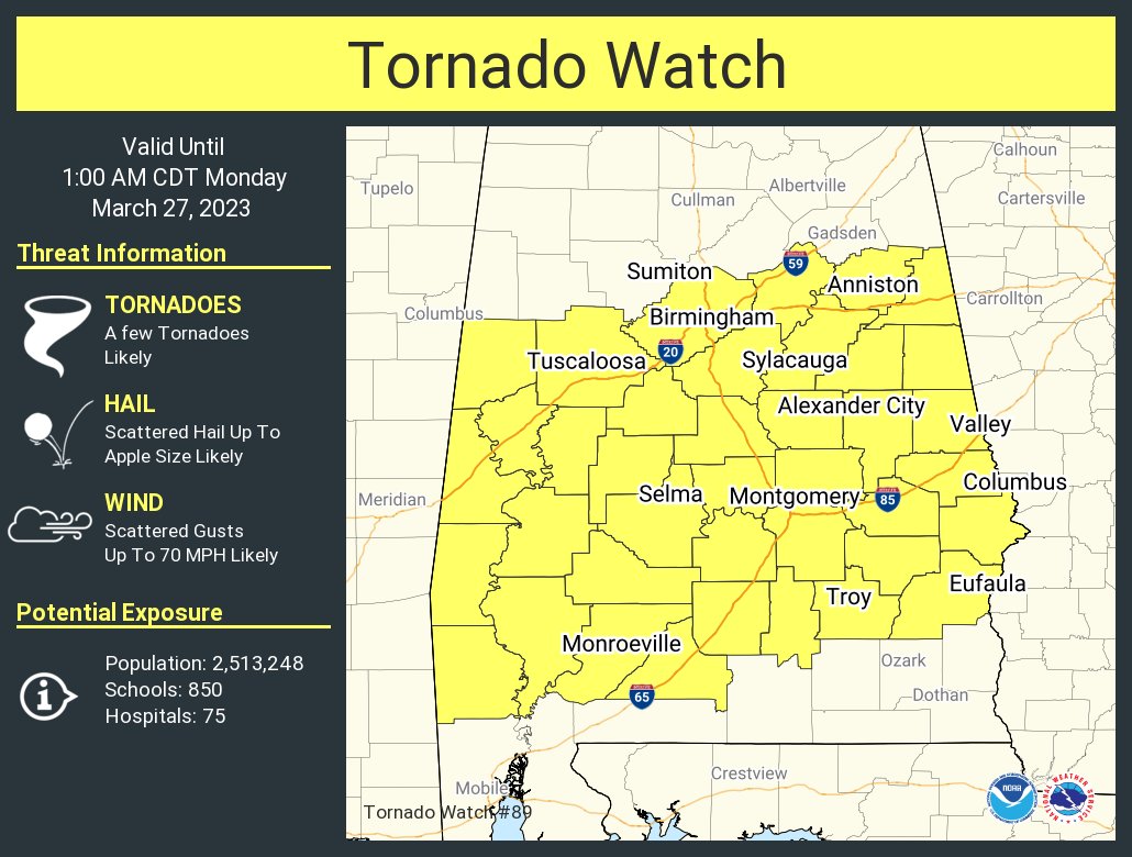
The SPC and NWS Birmingham have issued a new TORNADO WATCH effective immediately for the following counties in Central Alabama: Autauga, Barbour, Bibb, Bullock, Calhoun, Chambers, Chilton, Clay, Cleburne, Coosa, Dallas, Elmore, Greene, Hale, Jefferson, Lee, Lowndes, Macon, Marengo, Montgomery, Perry, Pike, Pickens, Randolph, Russell, Shelby, St. Clair, Sumter, Talladega, Tallapoosa, and Tuscaloosa. This watch is set to expire at 1 am Monday.
The NWS Storm Prediction Center has issued a
* Tornado Watch for portions of
Central and southern Alabama
* Effective this Sunday afternoon and Monday morning from 550 PM
until 100 AM CDT.
* Primary threats include…
A few tornadoes likely with a couple intense tornadoes possible
Scattered large hail and isolated very large hail events to 3
inches in diameter likely
Scattered damaging wind gusts to 70 mph likely
SUMMARY… Initial splitting supercells will persist this evening
across southern/central Alabama, with the threat for isolated very
large hail (2-3 inches in diameter). Later this evening, supercell
clusters will spread eastward from Mississippi into Alabama, when
the storm environment will become more favorable for tornadoes (a
couple of which could be strong). The threat for damaging winds to
70 mph and very large hail will persist into the early overnight
hours.
Category: Alabama's Weather, ALL POSTS, Severe Weather
About the Author (Author Profile)
Scott Martin is an operational meteorologist, professional graphic artist, musician, husband, and father. Not only is Scott a member of the National Weather Association, but he is also the Central Alabama Chapter of the NWA president. Scott is also the co-founder of Racecast Weather, which provides forecasts for many racing series across the USA. He also supplies forecasts for the BassMaster Elite Series events including the BassMaster Classic.Subscribe
If you enjoyed this article, subscribe to receive more just like it.


