Tornado Threat Continues for Current Locations in Tornado Watch
Over the next few hours, the greatest tornado risk will be over Middle Tennessee and into the extreme northwest corner of Alabama, which includes the locations under the current tornado watch in effect for Colbert, Franklin, and Lauderdale counties.
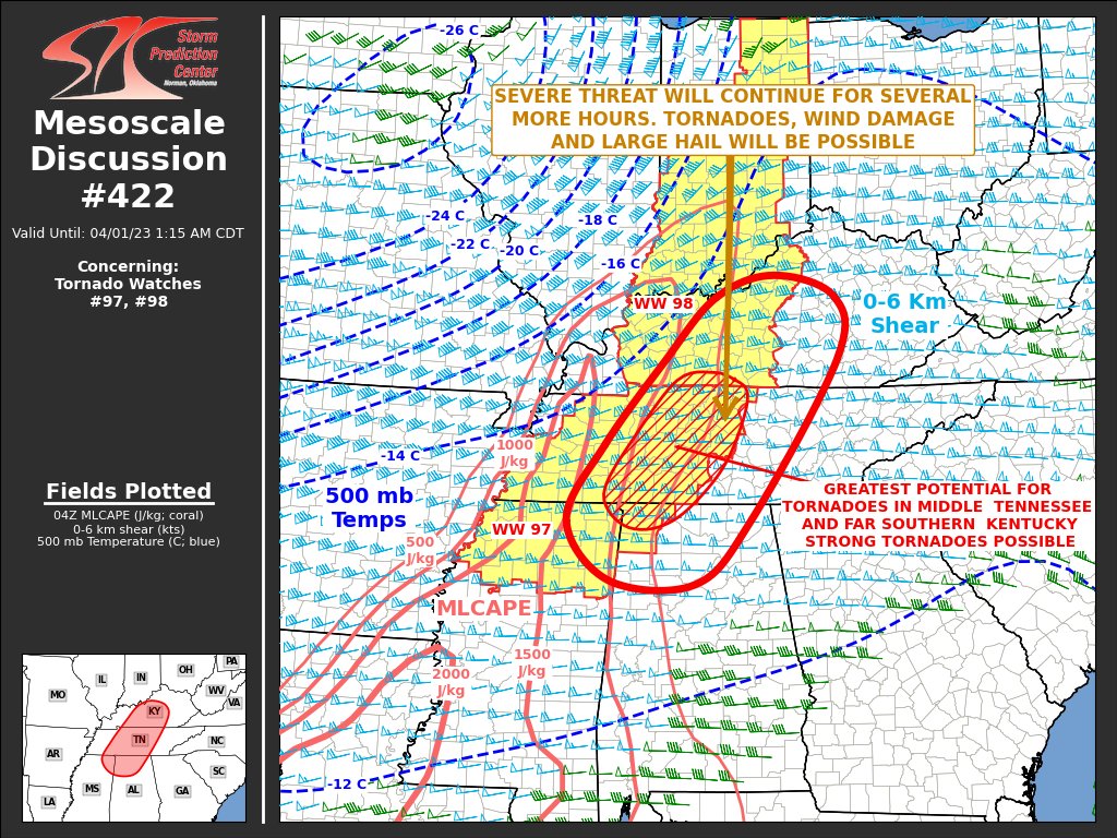
Here is the text from the Mesoscale Discussion…
The severe weather threat for Tornado Watch 97, 98 continues.
SUMMARY… Severe threat will continue for several more hours across the Tennessee Valley. The threat will likely increase in middle Tennessee, northeast Mississippi, northwest Alabama and in south-central Kentucky. Tornadoes, wind damage and large hail will be possible. Weather watch issuance may become necessary to the east of WW 97 and WW 98.
DISCUSSION… The latest WSR-88D radar from Nashville shows a broken line of strong to severe storms, extending from northern Mississippi northeastward into western Tennessee and southwest Kentucky. The line contains several supercells and bowing line segments, some of which are producing tornadoes and wind damage. The storms are located to the east of an axis of moderate instability, and just east of the southern extension of a 50 to 70 knot low-level jet.
RAP forecast soundings across middle Tennessee late this evening have long and looped hodographs, with 0-6 km shear near 70 knots and 0-3 km storm-relative helicity above 600 m2/s2. The strong low-level shear will continue to be favorable for the maintenance of low-level mesocyclones. The more dominant supercells may produce tornadoes, with strong tornadoes possible. Wind damage will also be likely with supercells, and bowing line segments. Swaths of damaging winds will be most likely with fast-moving bow echoes. Large hail may also accompany the stronger updrafts.
Category: Alabama's Weather, ALL POSTS, Severe Weather
About the Author (Author Profile)
Scott Martin is an operational meteorologist, professional graphic artist, musician, husband, and father. Not only is Scott a member of the National Weather Association, but he is also the Central Alabama Chapter of the NWA president. Scott is also the co-founder of Racecast Weather, which provides forecasts for many racing series across the USA. He also supplies forecasts for the BassMaster Elite Series events including the BassMaster Classic.Subscribe
If you enjoyed this article, subscribe to receive more just like it.


