The Midday Report – Showers Moving Into the Western Parts of the Area
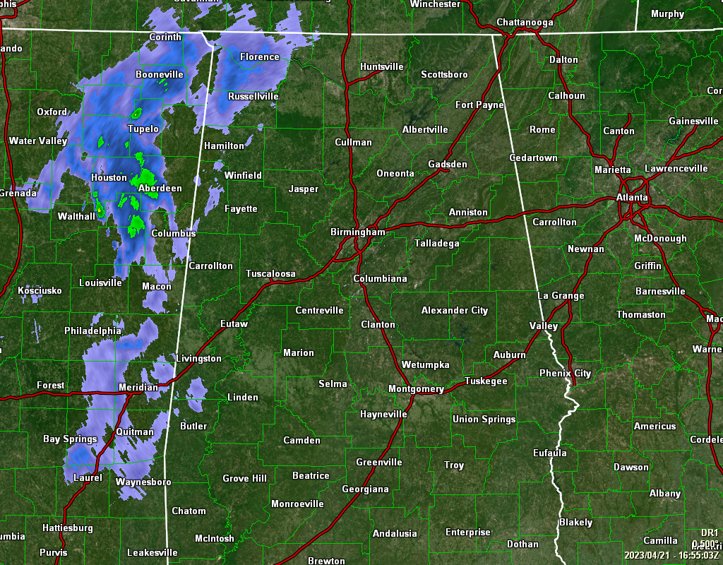
As we have now hit the afternoon in Central Alabama, showers have moved into the northwest corner of the state and starting to cross the MS/AL state line to the south of that. For now, all of this activity is light. For the rest of the area, we are dry. Temperatures as of the 12 pm roundup were in the lower 70s to the lower 80s. Haleyville was the cool spot at 70º. The warm spot was Troy at 81º. Birmingham was at 75º. Highs will eventually make it up into the mid 70s to the mid 80s. Rain chances will increase from west to east as the afternoon moves on, with the highest chances in the western portions. A few claps of thunder will also be possible.
For tonight, rain will be likely area wide, with the highest coverage north of the I-20 corridor. Once again, some thunder will be possible, but severe weather is not expected. Overnight lows will drop into the upper 40s to the upper 50s from northwest to southeast.
For the Central Alabama weekend, weather will be fantastic across the area. After the back edge of the rain moves out early on Saturday morning, clouds will be decreasing and afternoon highs will be in the 70s area wide. Tons of sunshine can be expected on Sunday, with highs in the mid 60s to the upper 70s.
Monday will start the week of dry with partly sunny skies and highs in the mid 60s to the mid 70s. After that, each day through the end of the forecast period on Thursday will have a chance of showers at any time. Highs will range from the mid to upper 60s to the mid to upper 70s.
Back in 2007… The South Plains and Panhandle of West Texas were hit by an outbreak of severe thunderstorms. Between the hours of 5 and 6 pm, several thunderstorms developed across the western South Plains. Around 7 pm, a supercell produced a tornado which touched down around Fieldton (southwest of Olton) and then moved just south and east of Olton, doing damage to several structures and equipment. The thunderstorm continued to move northeast across northeast Lamb, northwest Hale, southeast Castro and southwest Swisher Counties, producing a long-lived tornado (along with hail up to the size of tennis balls). By 7:45 pm, the storm approached the town of Tulia in Swisher County. A tornado touchdown was reported in the town, causing major damage. The tornadic thunderstorm continued to move northeast across Swisher County over open country through about 8:30 pm.
Category: Alabama's Weather, ALL POSTS
About the Author (Author Profile)
Scott Martin is an operational meteorologist, professional graphic artist, musician, husband, and father. Not only is Scott a member of the National Weather Association, but he is also the Central Alabama Chapter of the NWA president. Scott is also the co-founder of Racecast Weather, which provides forecasts for many racing series across the USA. He also supplies forecasts for the BassMaster Elite Series events including the BassMaster Classic.Subscribe
If you enjoyed this article, subscribe to receive more just like it.


