New Slight Risk Area Added to North/Central Alabama for Today
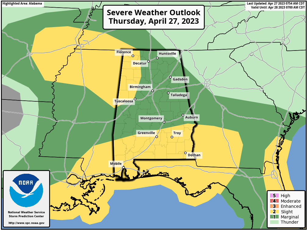
A Slight Risk for severe storms has been added to the northwestern parts of the area along and west of a line from Lexington (Lauderdale Co.) to Oakman (Walker Co.) to Northport (Tuscaloosa Co.) to just north of Geiger (Sumter Co.).
A Slight Risk continues for the southern parts of the state and includes portions of Central Alabama along and south of a line from just north of Fort Deposit (Lowndes Co.) to Hurtsboro (Russell Co.).
The rest of the state, except for locations east of Hytop (Jackson Co.) to Valley Head (DeKalb Co.), remains in a Marginal Risk.
Summary from the SPC: Severe storms are expected along much of the Gulf Coast Thursday, from portions of south Texas and southern Louisiana into the Florida Panhandle. Damaging gusts, large hail, and a few tornadoes will all be possible. Severe thunderstorms are also expected across the eastern Florida Peninsula and parts of the Mid-South. Hail and wind are the primary concerns with this activity.
Category: Alabama's Weather, ALL POSTS, Severe Weather
About the Author (Author Profile)
Scott Martin is an operational meteorologist, professional graphic artist, musician, husband, and father. Not only is Scott a member of the National Weather Association, but he is also the Central Alabama Chapter of the NWA president. Scott is also the co-founder of Racecast Weather, which provides forecasts for many racing series across the USA. He also supplies forecasts for the BassMaster Elite Series events including the BassMaster Classic.Subscribe
If you enjoyed this article, subscribe to receive more just like it.


