Mesoscale Discussion #644: Threat for Severe Hail & Damaging Winds Continue Across the Current Watch Area
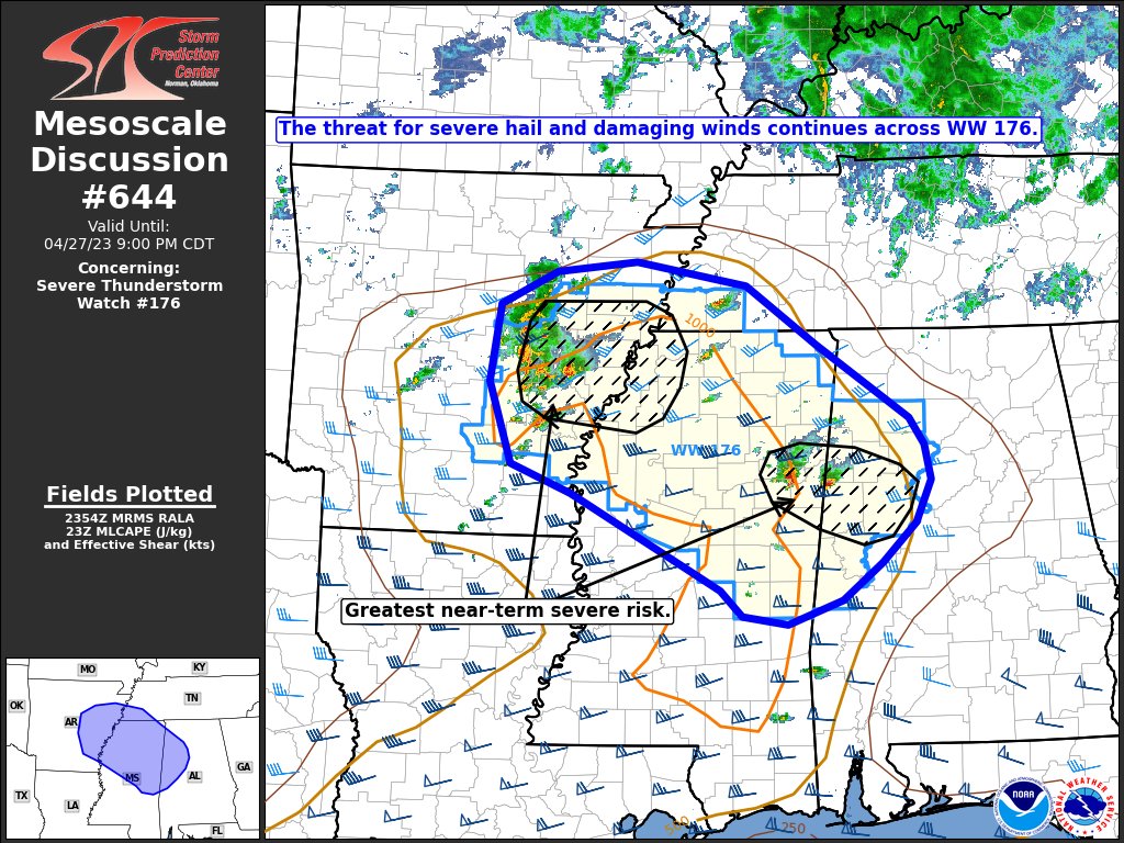
SUMMARY… The threat for severe hail and damaging winds continues across much of WW 176, but the greatest near-term risk will reside across eastern Arkansas into northwest Mississippi and far eastern Mississippi to far west/northwest Alabama.
DISCUSSION… Scattered convection continues to erupt immediately ahead of a mid-level vorticity maximum traversing across central AR. This zone of focused ascent, combined with a favorable thermodynamic and kinematic environment, has supported splitting supercells, including a more prominent/robust cell across Arkansas/Monroe counties that has remained relatively isolated. These cells will continue to pose a large hail threat for the next 1-2 hours as they move towards the apex of the MLCAPE axis across northwest MS. However, long-term trends are somewhat uncertain given consolidating convection along an outflow boundary to the west of the more discrete activity, and the propensity for storm interactions/amalgamating outflows with time within the focused zone of ascent. Such upscale growth may favor an increasing damaging wind threat, but weak low-level shear (around 20-25 knots in the 0-3 km layer) sampled by regional VWPs casts uncertainty onto this scenario.
To the east along the MS/AL border, a pair of long-lived supercells with a history of 1-1.75 inch hail will begin to gradually meander into the periphery of the higher mixed-layer buoyancy as they migrate into western AL. However, the isolated nature of the convection combined with 40-45 knots of effective bulk shear downstream should help maintain storm intensity and the associated large hail threat for the next few hours. Elsewhere across WW 176, environmental parameters remain conducive for organized convection, but additional CI is uncertain. The most likely location for near-term CI appears to be across northwest MS where the GOES day cloud phase RGB and low-level water vapor imagery shows shallow convective towers, but robust convective initiation remains uncertain given the onset of diurnal cooling.
Category: Alabama's Weather, ALL POSTS, Severe Weather
About the Author (Author Profile)
Scott Martin is an operational meteorologist, professional graphic artist, musician, husband, and father. Not only is Scott a member of the National Weather Association, but he is also the Central Alabama Chapter of the NWA president. Scott is also the co-founder of Racecast Weather, which provides forecasts for many racing series across the USA. He also supplies forecasts for the BassMaster Elite Series events including the BassMaster Classic.Subscribe
If you enjoyed this article, subscribe to receive more just like it.


