Checking on the Alabama Weather Situation at 8:10 p.m.
Our line of showers and storms is over Alabama’s western border counties at this hour.
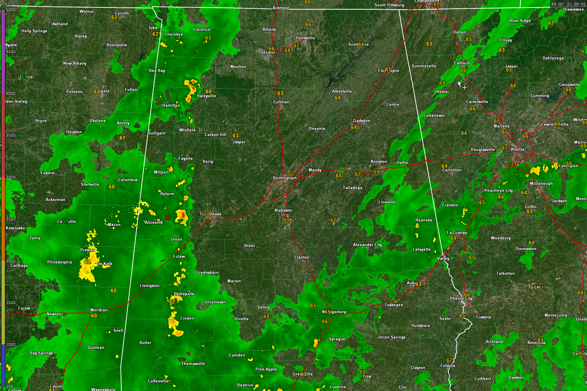
The line stretches from near Hackleburg to near Reform in Pickens County, to Brilliant, with a break to near Newtonville in Fayette County, to the southwest of Elrod in Tuscaloosa County. This storm will move through the Tuscaloosa area. The line is pushing steadily eastward at 15 mph. At this rate of speed, the line will reach Tuscaloosa around 845 pm, the Birmingham Metro between 1015 and 1045 pm, Pell City and Gadsden around midnight, and Anniston around 130 a.m. Actual times may vary of course and we will be updating those as we go through the evening.
The window for severe weather is closing rapidly and we should just be dealing with a line of showers with some embedded thunder. Right now, lightning is limited to the cells in Franklin and Marion Counties and Pickens and western Tuscaloosa back through Sumter and Greene. Any stronger storms have a small chance to produce some hail, but it should be sub-severe.
Looking at the underlying parameters tonight, there is modest CAPE or instability over all of Central and North Alabama, good low-level and decent mid-level lapse rates, but almost no shear, so the showers and storms will be in a line as we see now. There is no low-level shear, so tornadoes aren’t a threat. The only real threat is for some small hail.
Rain will end in Jasper and Tuscaloosa by 3 a.m., Birmingham by 5 a.m. and Anniston by 7 a.m. The rain should be out of Central Alabama by 8 a.m. Sunday. Skies will begin clearing from the northwest starting around 3 a.m. with the clearing reaching the I-59 corridor between 7 and 8 a.m. The rest of the day will feature
Winds will become gusty overnight, reaching 25 mph at times. The guest winds will continue through the day tomorrow. Highs tomorrow will be in the upper 60s North to lower 70s North Central and middle 70s South Central. Lows Sunday night will be in the 40s, with a few 30s in the normally colder locations of North Alabama.
The low-pressure system that is causing the rain and thunder for us here in Alabama is also causing stronger storms over the Florida Peninsula tonight where a tornado watch is in effect. They have a chance of tornadoes with any supercells that manage to develop.
Category: Alabama's Weather, ALL POSTS
About the Author (Author Profile)
Bill Murray is the President of The Weather Factory. He is the site's official weather historian and a weekend forecaster. He also anchors the site's severe weather coverage. Bill Murray is the proud holder of National Weather Association Digital Seal #0001 @wxhistorianSubscribe
If you enjoyed this article, subscribe to receive more just like it.


