

Your Sunday Weather Briefing Video: Clearing and Breezy Today, Dry Through Thursdsay
Saturday started off sunny across much of the North and Central parts of Alabama but clouds quickly moved in from the southwest as a low pressure system over the Delta of western Mississippi slid to the east. Temperatures started out in the 50s for the most part with a few 40s over North and East Alabama. Afternoon readings made it into the 70s across the area, but could not make the 80s at any Central Alabama locations due to the clouds. Rain and storms moved in late in the day and made for a wet night for many. The strong storms were a no-show, which was a good thing.
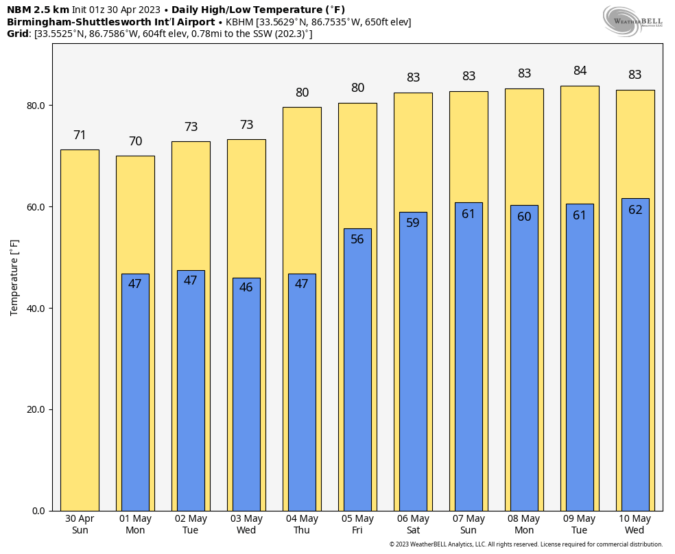
HONDA INDY TIME: Rain will be moving out of the area on this morning, and that will leave us with clearing skies, cooler temperatures, and breezy conditions during the afternoon. Highs will be in the upper 60s to the upper 70s. Perfect weather for the big race day at Birmingham’s beautiful Barber Motor Sports Park! Go check it out!
END OF THE MONTH: We say goodbye to April tonight and will be getting ready for those May flowers because we are going to finish around an inch above normal for the month, at least at the Birmingham Shuttlesworth International Airport. But most of the rain over the last 30 days has fallen in a 50 mile wide band along and northwest of I-59. Much of the rest of the northern half of the state has been dry.
GETTING READY FOR A NEW WORK WEEK: We will start off in the 40s across most of the area Monday morning. Some of the normally colder areas may drop into the upper 30s. Stop me if you have heard that one this spring. It looks like things will be dry through Thursday. Temperatures will be slightly cooler than normal through Wednesday, with average highs between 70-74. Lows will be in the 40s each morning. By Thursday, highs will be near 80.
STORMS FOR THE END OF THE WEEK: By late Thursday, the northwesterly flow that will be in place aloft over Alabama and the Southeast may turn on us in the form of storm complexes sliding our way from the Midwest. The forecast is very uncertain, but keep the threat of strong to severe storms in the back of your mind for Friday and perhaps into the weekend. This is not an unusual pattern for Alabama in May. It can lead to strong wind events. Not a forecast but a possibility.
VOODOO TERRITORY: The week two period will be much warmer. Highs each day will be in the 80s. Lows will be near 60F.
BEACHCAST: A beautiful week along the gorgeous beaches of Alabama and Northwest Florida, at least though early Friday. Showers and storms will return Friday and will last into the weekend. Highs will be in the middle and upper 70s. Lows will be in the upper 50s. Water temperatures are in the lower 70s. There is a high risk of rip currents today and tonight with high surf running 4-6 feet. Double red flags are flying, so stay out of the water.
Click here to see the Beach Forecast Center page.
NATIONALLY: There was an EF1 tornado in all that mess Friday afternoon northwest of Temple and Killeen in Texas. The tornado was mostly on Fort Hood. Boy, that looked like it was going to be a mess for those folks, but it fortunately morphed into a squall line just in time to take the tornado threat pretty much off the table.
DANCING WITH THE STATS: 86F at the Reno/Tahoe Airport yesterday tied the record for the date. The high at Truckee on Saturday was 72F, after a morning low of 32F. Those warm readings will melt some snow up in the Sierra.
TWITTER TROUBLE: Our NWS Partners have been told by Twitter that there is no guarantee their automated tweets for watches and warnings will go out in a timely fashion. Some offices have had their Twitter accounts suspended because of automated tweets. There are discussions going on behind the scenes and hopefully progress will come out of that process. . While this won’t have as big of an impact on the NWS Birmingham, since they don’t send out automated tweets, there is concern since the NWS doesn’t control the dissemination of weather information over social media challenges, and cannot guarantee the delivery of life saving weather information when it is needed most. The screaming message is that you should always have multiple ways for receiving severe weather warnings, including NOAA WeatherRadio, apps, WEA alerts over your smartphone, and of course, radio, TV, and the blog. Know your reliable sources and stick with them.
ADVERTISE WITH US: Deliver your message to a highly engaged audience by advertising on the AlabamaWX.com website. We have a lot of big plans for this year. Don’t miss out! We can customize a creative, flexible, and affordable package that will suit your organization’s needs. Contact me, Bill Murray, at (205) 687-0782 and let’s talk.
WEATHERBRAINS: This week, the panel will entertain Dr. Brian Jewett, who is an expert on long track tornadoes. Check out the show at www.WeatherBrains.com. You can also subscribe on iTunes. You can watch the show live on our new YouTube channel for the show.You will be able to see the show on the James Spann 24×7 weather channel on cable or directly over the air on the dot 2 feed.
ON THIS DATE IN 1953: A major tornado struck Warner Robins AFB GA, killing 18 Air Force personnel and family members. The storm was the worst in the Southeastern U.S. in the very bad 1953 tornado season. Follow my weather history tweets on Twitter. I am @wxhistorian at Twitter.com.
Category: Alabama's Weather, ALL POSTS, Weather Xtreme Videos
About the Author (Author Profile)
Bill Murray is the President of The Weather Factory. He is the site's official weather historian and a weekend forecaster. He also anchors the site's severe weather coverage. Bill Murray is the proud holder of National Weather Association Digital Seal #0001 @wxhistorianSubscribe
If you enjoyed this article, subscribe to receive more just like it.


