

Midday Nowcast: Mainly Cloudy with Scattered Showers
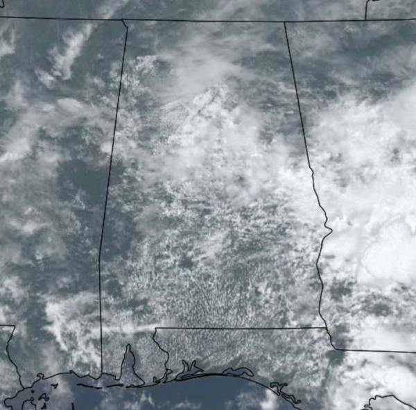
A mainly cloudy Monday across Alabama as a weak upper low moves across the Gulf Coast States. We have some scattered showers on the radar and through the afternoon we are looking for the coverage to increase across the state. We note, the SPC maintains a “marginal risk” (level 1/5) of severe thunderstorms over parts of South and Southeast Alabama this afternoon and early tonight as a few storms down that way could produce strong, gusty winds in heavier thunderstorms.
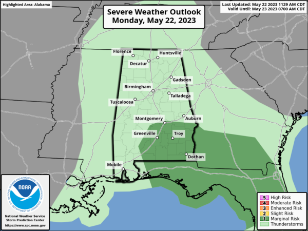
Additionally the southeast corner of the state is under a flash flood watch; this includes Coffee, Dale, Geneva, Houston, and Henry counties. Not everyone will see rain today, but we should all expect a high around 80 degrees.
Little change in the forecast tomorrow as the upper-level low continues to move slowly through the region. Expect rain on the radar, and like today, it will be more numerous over the southern 2/3 of the state. Expect another mostly cloudy day, and it will be cool for late May in Alabama with highs in the low to mid 70s.
WEDNESDAY THROUGH FRIDAY: On the back side of the departing upper low, drier air moves into the state for Wednesday and Thursday. Both days we are forecasting generally rain-free weather with a mostly sunny sky. Afternoon highs will be in the 80s. On Friday we will introduce the chance of a few widely scattered showers, but for now we don’t expect any widespread or heavy rain. Friday’s high will be in the low 80s with a mix of sun and clouds.
MEMORIAL DAY WEEKEND: For now, the weekend looks mainly dry, but we will maintain the chance of a few isolated showers both days, mainly during the afternoon and evening hours. Expect a partly sunny sky with highs in the 80s. A pretty typical forecast for the last weekend of May
NEXT WEEK: The week looks fairly quiet with no major weather systems impacting the Deep South. There will be a few days with the usual risk of widely scattered afternoon/evening showers or storms, however. Heat levels begin to rise, and by the end of the week afternoon highs will be close to 90°.
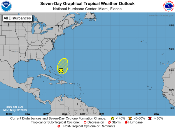
IN THE TROPICS: Showers and a few thunderstorms associated with a broad area of low pressure located a couple of hundred miles northeast of the central Bahamas remain poorly organized. Strong upper-level winds and dry air are expected to prevent development while the system moves generally north-northeastward at 5 to 10 mph over the southwestern Atlantic during the next day or so. Formation chance through 7 days…low…10 percent. The rest of the Atlantic basin is quiet… the hurricane season officially begins June 1.
BEACH FORECAST CENTER: Get the latest weather and rip current forecasts for the beaches from Fort Morgan to Panama City on our Beach Forecast Center page. There, you can select the forecast of the region that you are interested in visiting.
WORLD TEMPERATURE EXTREMES: Over the last 24 hours, the highest observation outside the U.S. was 115.7F at Jhanis, India. The lowest observation was -100.8F Dome C, Antarctica.
CONTIGUOUS TEMPERATURE EXTREMES: Over the last 24 hours, the highest observation was 106F at Death Valley, CA. The lowest observation was 21F at Peter Sinks, UT.
Category: Alabama's Weather, ALL POSTS
About the Author (Author Profile)
Macon, Georgia Television Chief Meteorologist, Birmingham native, and long time Contributor on AlabamaWX. Stormchaser. I did not choose Weather, it chose Me. College Football Fanatic. @Ryan_StinnetSubscribe
If you enjoyed this article, subscribe to receive more just like it.


