Saturday Weather Briefing Video: Extended Run of Wet, Stormy Weather to Continue
The past few days have been extremely stormy across Alabama and much of the South. Throw in a very active day yesterday in Oklahoma and the Texas Panhandle and it has turned tragic.
THE GOOD NEWS: Is the rainfall. But it has been uneven It is distribution. After forecasting a week ago that many areas would average 4.5 inches, some have indeed picked up that much. But others have had barely one half inch. Like the Birmingham Airport and parts of North Birmingham. So even where there has been bad news there still may be good news in the rainfall department over the next week. The GFS is again forecasting substantial amounts across a good bit of Alabama. Fingers crossed for beneficial rain and not flooding.
Here are rainfall amounts through next Friday evening courtesy of the Weather Prediction Center at NOAA.
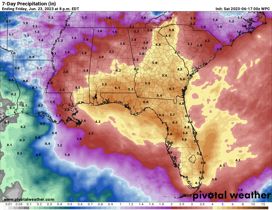
BUT TALK ABOUT FLOODING: How about the Pensacola area. Some places like Warrington picked up 15.23 inches Thursday night into early Friday morning. Gulf Breeze picked up 14.08”. There were plenty of high water rescues and flooded structures. And to add insult to injury, there was a tornado that dropped south across Pensacola and Escambia Bay before crossing the Gulf Islands National Seashore west of Pensacola Beach.
BIG HAILERS: Big storms developed in eastern Mississippi late Friday afternoon and evening. A severe thunderstorm watch was issued and the storms grew in intensity. Large hail was reported Trees were blown down in Pickens and Sumter Counties, including 30-40 trees around Cuba. Trees were also blown down in Tallapoosa County and in other Central Alabama locations. Probably the largest hail reports in Alabama were 2.75 inches at Coal Fire and Forest in Pickens County. That’s the size of baseballs.
PATTERN NOT A CHANGIN’: Folks it looks wet and potentially stormy for the next several days, perhaps well in to the week two forecast period. Which is good for moisture and keeping those really hot days that are coming at bay for the time being.
FOR YOUR SATURDAY: Things are calm this morning across North and Central Alabama. Temperatures are starting off in the middle and upper 60s. We will see some sunshine especially during the late morning hours, and that will push readings in the middle and upper 80s by afternoon. There is some disagreement about coverage of afternoon showers and storms. The HRRR depicts a decent batch of showers and storms moving southeastward across the area. The SPC does have roughly the southern half of Alabama in a Marginal Risk (Level 1 out of 5) with a Slight Risk across far South Alabama.
HAPPY FATHER’S DAY: Tomorrow looks mostly cloudy, but mostly dry. A weakening batch of showers could arrive by mid-afternoon, but a bigger, badder batch will arrive after midnight. That is probably the best time for the SPC Slight Risk to manifest itself into severe weather. Rainfall could be heavy, perhaps averaging 1.5-2” across the area, with bigger amounts in stronger storms. Highs will be in the middle and upper 80s.
HOLIDAY WEATHER: Juneteenth Monday looks a little less stormy, except over South Alabama. But still, scattered afternoon and evening storms are a good bet.
BACK TO WORK: Rest of the work week looks partly sunny to occasionally cloudy with scattered showers and storms forming mainly during the afternoon and evening hours. Temperatures will be a little cooler than average, generally in the lower and middle 80s by afternoon. Slightly drier air at midweek will drop overnight readings into the lower and middle 60s.
WEEKEND OUTLOOK: We may get a bit of a reprieve Saturday, but showers and storms will be back in the forecast by Sunday. Temperatures will be back into the upper 80s pushing 90F.
WEEK TWO VOODOO: Week two doesn’t look much better with elevated rain chances staying with us. Some relief from the rain may be in sight by late in the week.
BEACHCAST: Severe storms are likely along the beautiful beaches of Alabama and Northwest Florida late this afternoon as storms form over South Alabama and sink southward. Sunday looks drier, but it is temporary as showers and storms remain in the forecast all week. Highs are going to be in the upper 80s, with lows in the middle 70s. Water temperatures now are running a toasty 80 degrees. The rip current risk will remain high all week, so let’s be very careful and not lose anyone this week.
Click here to see the Beach Forecast Center page.
TROPICS: It appears that there is a high chance that a tropical depression will form in the eastern Atlantic over the weekend. That is unusual enough, as we usually have to wait until much later in the season to see tropical cyclone development out in the Main Development Region of the Atlantic. It appears that the storm will become a named storm, Bret, and likely a hurricane as it tracks across the Atlantic. Most everything we see says it will recurve east of the islands, sparing the Lesser Antilles and passing east of Bermuda. It does not appear to be a threat to affect the United States directly.
DANCING WITH THE STATS: The 9.2 3inches of rain that fell in six hours at the Pensacola Airport between 7pm and 1 a.m. Thursday night and early Friday was a record for any June 15th. The return period on such a rainfall event is between 50 and 100 years there.
ADVERTISE WITH US: Deliver your message to a highly engaged audience by advertising on the AlabamaWX.com website. We have a lot of big plans for this year. Don’t miss out! We can customize a creative, flexible, and affordable package that will suit your organization’s needs. Contact me, Bill Murray, at (205) 687-0782 and let’s talk.
WEATHERBRAINS: This week, the panel will entertain extreme weather expert Randy Cerveny from Arizona State University. That show was recorded Thursday night and will be launched to the world late Monday night. Check out the show at www.WeatherBrains.com. You can also subscribe on iTunes. You can watch the show live on our new YouTube channel for the show.You will be able to see the show on the James Spann 24×7 weather channel on cable or directly over the air on the dot 2 feed.
ON THIS DATE IN 1972: Agnes was born on this date, forming as a tropical storm east of the Yucatan Peninsula. Agnes would be a storm with two distinct lives. She would move north over the Gulf of Mexico and strike the Florida Panhandle as a minimal hurricane. A few days later, the remnants of Hurricane Agnes would be rejuvenated over the Northeast, dumping heavy amounts of rain and causing record flooding across area from the 20th through the 24th. Follow my weather history tweets on Twitter. I am @wxhistorian at Twitter.com.
Category: Alabama's Weather, ALL POSTS, Severe Weather
About the Author (Author Profile)
Bill Murray is the President of The Weather Factory. He is the site's official weather historian and a weekend forecaster. He also anchors the site's severe weather coverage. Bill Murray is the proud holder of National Weather Association Digital Seal #0001 @wxhistorianSubscribe
If you enjoyed this article, subscribe to receive more just like it.


